 INSPIRE-1
HpnV - HpnV Kartiereinheit
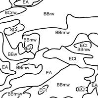
Heutige potentielle natürliche Vegetation:In der Karte der Heutigen potentiellen natürlichen Vegetation (HpnV) werden als Kartiereinheiten die Schlussgesellschaften der Vegetationsentwicklung (i.d.R. Waldgesellschaften) dargestellt, die ohne menschlichen Einfluss unter heutigen Standortbedingungen vorkämen. Sie stellt damit eine vegetationskundliche Standortkarte dar. Sichtbar ab einem Maßstab von 1:100.000 oder größer.
|
|
Citation proposal
. HpnV - HpnV Kartiereinheit. Landesamt für Umwelt Rheinland-Pfalz http://gdk-inspire-1.ffm.gdi-de.org/geonetwork/srv/api/records/0399a29f-8d67-3fb3-7f79-405c4c35c3de |
- Identification
- Distribution
- Quality
- Spatial rep.
- Ref. system
- Content
- Portrayal
- Metadata
- Md. constraints
- Md. maintenance
- Schema info
Identification
Identification info
Service Identification (19119)
Citation
- Alternate title
- Date ( Revision )
- 2023-11-28
Publisher
- mapbender.2.registryId
-
- 2f23ed6e-0186-4c2b-8380-748389036509
- Keywords
-
- LfU
- heutige
- potentielle
- natürliche
- Vegetation
- Pflanzen
- infoMapAccessService
- inspireidentifiziert
Legal constraints
- Access constraints
- Other restrictions
Legal constraints
- Use constraints
- Other restrictions
- Other constraints
- keine - Lizenz: odc-odbl-1.0 - Open Data Commons Open Database License (ODbL) - http://opendatacommons.org/licenses/odbl/1.0/
- Other constraints
- {"id":"odc-odbl-1.0","name":"Open Data Commons Open Database License (ODbL)","url":"http:\/\/opendatacommons.org\/licenses\/odbl\/1.0\/"}
- Service Type
- view
- Service Version
- OGC:WMS 1.1.1
N
S
E
W
))
- Coupling Type
- Tight
Contains Operations
- Operation Name
- GetCapabilities
- Distributed Computing Platforms
- Web services
Distribution
Distribution
- Distribution format
-
- ()
- OnLine resource
-
hpnv_kartiereinheit
In der Karte der Heutigen potentiellen natürlichen Vegetation (HpnV) werden als Kartiereinheiten die Schlussgesellschaften der Vegetationsentwicklung (i.d.R. Waldgesellschaften) dargestellt, die ohne menschlichen Einfluss unter heutigen Standortbedingungen vorkämen. Sie stellt damit eine vegetationskundliche Standortkarte dar. Sichtbar ab einem Maßstab von 1:100.000 oder größer.
Quality
Data quality
Scope
- Hierarchy level
- service Service
- Other
- Dienst
Conformance result
Citation
- Date ( Publication )
- 2010-12-08
- Explanation
- No explanation available
- Pass
- true
Conformance result
Citation
- Date ( Publication )
- 2009-10-20
- Explanation
- No explanation available
- Pass
- true
Conformance result
Citation
- Date ( Publication )
- 2014-12-11
- Explanation
- No explanation available
- Pass
- true
Conformance result
Citation
- Date ( Publication )
- 2008-12-04
- Explanation
- No explanation available
- Pass
- true
Conformance result
Citation
- Date ( Publication )
- 2014-12-11
- Explanation
- No explanation available
- Pass
- true
Conformance result
Citation
- Date ( Publication )
- 2013-12-10
- Explanation
- No explanation available
- Pass
- true
Conformance result
Citation
- Date ( Publication )
- 2011-02-05
- Explanation
- No explanation available
- Pass
- true
Conformance result
Citation
- Date ( Publication )
- 2010-12-08
- Explanation
- No explanation available
- Pass
- true
Metadata
Metadata
- File identifier
- 0399a29f-8d67-3fb3-7f79-405c4c35c3de XML
- Metadata language
- Deutsch German
- Character set
- UTF8
- Hierarchy level
- service Service
- Hierarchy level name
- Darstellungsdienst
- Date stamp
- 2025-11-23
- Metadata standard name
- ISO19119
- Metadata standard version
- 2005/PDAM 1
Point of contact
Overviews
Thumbnail
Provided by

Views
0399a29f-8d67-3fb3-7f79-405c4c35c3de
Access to the portal
Read here the full details and access to the data.
Associated resources
Not available