 INSPIRE-1
Georisiken in Bayern - WMS
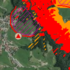
Der Web Map Service Georisiken in Bayern beinhaltet die GEORISK-Objekte (Felsstürze, Rutschungen, Schuttströme, Erdfälle etc.) mit deren Anbruch- und Ablagerungsbereichen. Zudem beinhaltet er Gefahrenhinweiskarten, soweit diese bereits vorliegen. Diese enthalten eine Übersicht der Gefährdungssituation durch Geogefahren.
|
|
Citation proposal
(2014) . Georisiken in Bayern - WMS. http://gdk-inspire-1.ffm.gdi-de.org/geonetwork/srv/api/records/03f453e2-198a-3fed-b690-5650053ee4fe |
INSPIRE
Identification
- File identifier
- 03f453e2-198a-3fed-b690-5650053ee4fe XML
- Hierarchy level
- service Service
Online resource
Resource identifier
Encoding
- Format
- Sonstiges
Projection
Classification of data and services
Classification of data and services
- Service Type
- view
- Coupling Type
- Tight
Coupled resource
Coupled resource
Classification of data and services
- Service Type
- view
- Coupling Type
- Tight
Coupled resource
Coupled resource
Keywords
- GEMET - INSPIRE themes, version 1.0 ( Theme )
-
- Gebiete mit naturbedingten Risiken
- Service Classification, version 1.0 ( Theme )
-
- infoMapAccessService
- Spatial scope
Other keywords
- Keywords
-
- gdiby
- Georisiken
- Bodeninformationssystem Bayern
- BIS
- Gefahrenhinweiskarte
- Steinschlag
- Blockschlag
- Felssturz
- Bergsturz
- Rutschung
- Hangrutschung
- Doline
- Erdfall
- Keywords
-
- inspireidentifiziert
Geographic coverage
N
S
E
W
))
Temporal reference
Temporal extent
Temporal extent
- Date ( Publication )
- 2014-07-01T00:00:00.000+02:00
Quality and validity
Conformity
Conformity
Conformity
Conformity
Conformity
Conformity
- Explanation
- see the referenced specification
- Explanation
- see the referenced specification
- Explanation
- see the referenced specification
Restrictions on access and use
Restrictions on access and use
- Access constraints
- Creative Commons Namensnennung 4.0 International (CC BY 4.0); Datenquelle: Bayerisches Landesamt für Umwelt, www.lfu.bayern.de
- Access constraints
- {"id":"cc-by/4.0","name":"Creative Commons Namensnennung 4.0 International (CC BY 4.0)","url":"https://creativecommons.org/licenses/by/4.0/deed.de","quelle":"Bayerisches Landesamt für Umwelt, www.lfu.bayern.de"}
Responsible organization (s)
Contact for the resource
- Organisation name
- Bayerisches Landesamt für Umwelt
- Organisation name
- Bayerisches Landesamt für Umwelt
Responsible organization (s)
Contact for the resource
- Organisation name
- Bayerisches Landesamt für Umwelt
- Organisation name
- Bayerisches Landesamt für Umwelt
Metadata information
Contact for the metadata
- Organisation name
- Bayerisches Landesamt für Umwelt
- Date stamp
- 2024-06-28
- Metadata language
- German
SDS
Conformance class 1: invocable
- Pass
- true
- Pass
- true
- Pass
- false
Access Point URL
Endpoint URL
Technical specification
- Date
- Explanation
- see the referenced specification
- Date
- Explanation
- see the referenced specification
- Date
- Explanation
- see the referenced specification
Conformance class 2: interoperable
Coordinate reference system
Quality of Service
Access constraints
- Access constraints
- otherRestrictions Other restrictions
Limitation
Use constraints
Limitation
- string
- Creative Commons Namensnennung 4.0 International (CC BY 4.0); Datenquelle: Bayerisches Landesamt für Umwelt, www.lfu.bayern.de
- string
- {"id":"cc-by/4.0","name":"Creative Commons Namensnennung 4.0 International (CC BY 4.0)","url":"https://creativecommons.org/licenses/by/4.0/deed.de","quelle":"Bayerisches Landesamt für Umwelt, www.lfu.bayern.de"}
Responsible custodian
Contact for the resource
Conformance class 3: harmonized
Contains Operations
- Operation Name
- GetCapabilities
- Distributed Computing Platforms
- Web services
- Operation Description
- application/vnd.ogc.wms_xml;
- Connect Point
- https://www.lfu.bayern.de/gdi/wms/geologie/georisiken?
Contains Operations
- Operation Name
- GetMap
- Distributed Computing Platforms
- Web services
- Operation Description
- image/png; image/jpeg; image/gif;
- Connect Point
- https://www.lfu.bayern.de/gdi/wms/geologie/georisiken?
Contains Operations
- Operation Name
- GetFeatureInfo
- Distributed Computing Platforms
- Web services
- Operation Description
- text/html; application/vnd.ogc.wms_xml; text/xml; text/plain;
- Connect Point
- https://www.lfu.bayern.de/gdi/wms/geologie/georisiken?
Overviews
Provided by

Views
03f453e2-198a-3fed-b690-5650053ee4fe
Access to the portal
Read here the full details and access to the data.
Associated resources
Not available