 INSPIRE-1
Historische Hochwasserereignisse - Downloaddienst
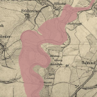
Der Downloaddienst stellt Daten zu Hochwasserereignissen, die in der Vergangenheit beobachtet wurden, als Shapefile bereit. Daten von größeren abgelaufenen Hochwasserereignissen werden – wenn möglich – erfasst und in Karten übertragen. Erfasst werden die flächige Ausdehnung und die Hochwasserlinie (äußere Abgrenzung des Hochwassers) sowie historische Wasserstandsmarken. Diese Information bildet in Verbindung mit den regelmäßigen Aufzeichnungen von Wasserständen an Pegeln eine wichtige Grundlage für die fachliche Bewertung der Hochwassergefahr.
|
|
Citation proposal
(2013) . Historische Hochwasserereignisse - Downloaddienst. http://gdk-inspire-1.ffm.gdi-de.org/geonetwork/srv/api/records/130c82fa-9310-4140-bfd5-6c5ab8976f96 |
Simple
Identification info
- Alternate title
- Historische Hochwasserereignisse
- Date ( Publication )
- 2013-08-23T00:00:00.000+02:00
- Status
- On going
Point of contact
- Website
- https://www.lfu.bayern.de
- Maintenance and update frequency
- Weekly
- Update scope
- Service
- GEMET - INSPIRE themes, version 1.0 ( Theme )
-
- Gebiete mit naturbedingten Risiken
- Service Classification, version 1.0 ( Theme )
-
- infoFeatureAccessService
- Keywords
-
- gdiby
- Überschwemmungsfläche
- historisches Hochwasserereignis
- Hochwasser
- Wasserstandsmarke
- Hochwassermarke
- Hochwasserlinie
- Geschwemmsellinie
- Spatial scope
- Keywords
-
- inspireidentifiziert
- Use limitation
- keine Einschränkungen
- Use constraints
- Other restrictions
- Other constraints
- Creative Commons Namensnennung - Weitergabe unter gleichen Bedingungen 4.0 International (CC BY-SA 4.0); Datenquelle: Bayerisches Landesamt für Umwelt, www.lfu.bayern.de
- Other constraints
- {"id":"cc-by-sa/4.0","name":"Creative Commons Namensnennung - Weitergabe unter gleichen Bedingungen 4.0 International (CC BY-SA 4.0)","url":"https://creativecommons.org/licenses/by-sa/4.0/deed.de","quelle":"Bayerisches Landesamt für Umwelt, www.lfu.bayern.de"}
- Access constraints
- otherRestrictions Other restrictions
- Service Type
- download
- Service Version
- predefined ATOM
- Description
- Der Dienst umfasst die Landesfläche Bayerns.
N
S
E
W
))
Coupled Resource
- Operation Name
- GetDownloadServiceMetadata
Coupled Resource
- Operation Name
- DescribeSpatialDataset
Coupled Resource
- Operation Name
- GetSpatialDataset
Coupled Resource
- Operation Name
- GetCapabilities
Coupled Resource
- Operation Name
- GetDownloadServiceMetadata
Coupled Resource
- Operation Name
- DescribeSpatialDataset
Coupled Resource
- Operation Name
- GetSpatialDataset
Coupled Resource
- Operation Name
- GetCapabilities
Coupled Resource
- Operation Name
- GetDownloadServiceMetadata
Coupled Resource
- Operation Name
- DescribeSpatialDataset
Coupled Resource
- Operation Name
- GetSpatialDataset
Coupled Resource
- Operation Name
- GetCapabilities
- Coupling Type
- Tight
Contains Operations
- Operation Name
- GetDownloadServiceMetadata
- Distributed Computing Platforms
- Web services
Contains Operations
- Operation Name
- DescribeSpatialDataset
- Distributed Computing Platforms
- Web services
Contains Operations
- Operation Name
- GetSpatialDataset
- Distributed Computing Platforms
- Web services
Contains Operations
- Operation Name
- GetCapabilities
- Distributed Computing Platforms
- Web services
- Distribution format
-
- Sonstiges ()
Distributor
Distributor
- Website
- https://www.lfu.bayern.de
- Fees
- geldleistungsfrei
- OnLine resource
-
https://www.lfu.bayern.de/gdi/dls/historische_ereignisse.xml
URL des Dienstes
- OnLine resource
-
Daten im UmweltAtlas Bayern
Die Daten können im UmweltAtlas Bayern aufgerufen werden.
- Hierarchy level
- Service
- Other
- service
Conformance result
- Date ( Publication )
- 2013-08-09
- Explanation
- see the referenced specification
- Pass
- true
Conformance result
- Date ( Publication )
- 2009-10-20
- Explanation
- see the referenced specification
- Pass
- true
Conformance result
- Date ( Publication )
- 2010-12-07
- Explanation
- see the referenced specification
- Pass
- false
gmd:MD_Metadata
- File identifier
- 130c82fa-9310-4140-bfd5-6c5ab8976f96 XML
- Metadata language
- German
- Character set
- UTF8
- Hierarchy level
- service Service
- Hierarchy level name
- service
- Date stamp
- 2025-08-13
- Metadata standard name
- ISO19119
- Metadata standard version
- 2005/PDAM 1
Point of contact
- Website
- https://www.lfu.bayern.de
Overviews
Provided by

Views
130c82fa-9310-4140-bfd5-6c5ab8976f96
Access to the portal
Read here the full details and access to the data.
Associated resources
Not available