 POC 3.12
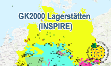
INSPIRE: Geoscientific Map of Germany 1:2,000,000 - Important deposits (GK2000 Lagerstätten) (WMS)
The WMS GK2000 Lagerstätten (INSPIRE) shows deposits and mines of energy resources, metal resources, industrial minerals and salt on a greatly simplified geology within Germany on a scale of 1:2,000,000. According to the Data Specification on Mineral Resources (D2.8.III.21) and Geology (D2.8.II.4_v3.0) the map provides INSPIRE-compliant data. The WMS GK2000 Lagerstätten (INSPIRE) contains the following layers:
MR.Mine displays mines. MR.MineralOccurence.Commodity.Polygon.EnergyResources displays energy resources as polygons. GE.GeologicUnits provides the greatly simplified geology of Germany. For different geochronologic minimum and maximum ages, e.g. Precambrian - Cenozoic, the portrayal is defined by the colour of the geochronologic minimum age (olderNamedAge). The user obtains detailed information on the deposits, mines and geology via the getFeatureInfo request.
Notes regarding the portrayal:
The gas and oil provinces as well as the corresponding mines are coloured in green and red according to common international practice. The black coal fields are displayed in their original colour grey. The colouring of the brown coal fields correspond to the KOR250 respectively KOR250 (INSPIRE) colouring. All mine symbols and commodity abbrevations are BGR symbols and abbrevations.
Der WMS GK2000 Lagerstätten (INSPIRE) zeigt Lagerstätten und Abbaustätten von Energierohstoffen, Metallrohstoffen, Industriemineralen und Salzen auf einer sehr stark vereinfachten Geologie innerhalb Deutschlands im Maßstab 1:2.000.000. Entsprechend der Datenspezifikationen Mineral Resources (D2.8.III.21) und Geology (D2.8.II.4_v3.0) liegen die Inhalte der Karte INSPIRE-konform vor. Die GK2000 Lagerstätten (INSPIRE) enthält folgende Layer:
MR.Mine stellt Abbaustätten dar. MR.MineralOccurence.Commodity.Polygon.EnergyResources stellt Energierohstoffe als Flächen dar.
GE.GeologicUnit stellt die sehr stark vereinfachte Geologie von Deutschland dar.
Bei unterschiedlichen geochronologischen Anfangs- und Endalter-Angaben, z.B. Precambrian - Cenozoic, entspricht die farbliche Darstellung dem geochronologischen Anfangsalter (olderNamedAge). Mit Hilfe der getFeatureInfo-Anfrage erhält der User Detailinformationen zu den Lagerstätten, Abbaustätten und der Geologie.
Anmerkungen zur Darstellung:
Die Gas- und Ölprovinzen sowie die entsprechenden Abbaustätten werden in den international üblichen Farben Grün und Rot dargestellt. Die Steinkohle-Reviere werden in der Original-Farbe Grau dargestellt. Die Farbgebung der Braunkohle-Reviere entspricht der Farbgebung in der KOR250 bzw. KOR250 (INSPIRE). Die Abbaustätten-Symbole und Rohstoff-Kürzel sind BGR-Symbole und -Kürzel.
Simple
Identification info
- Alternate title
-
GK2000 Lagerstätten (INSPIRE) (WMS)
- Date (Publication)
- 2020-10-23
- Identifier
- https://registry.gdi-de.org/id/de.bund.bgr.csw/8c445290-79b5-b5e7-0122-0bf3cc77f055
- Status
- Completed
-
GEMET - INSPIRE themes, version 1.0
-
-
Geologie
-
Geology
-
Mineralische Bodenschätze
-
Mineral resources
-
-
GEMET - Themes, version 4.1.4
-
-
black coal
-
coal
-
copper
-
crude oil
-
energy
-
energy resource
-
energy source
-
energy source material
-
fossil fuel
-
gypsum
-
lead
-
lignite
-
mine
-
mineral deposit
-
natural gas
-
nickel
-
ore
-
petroleum
-
potash
-
raw material
-
salt
-
sediment
-
silver
-
sulphur
-
uranium
-
zinc
-
- Place
-
-
Germany
-
Deutschland
-
-
Spatial scope
-
-
National
-
- Keywords
-
-
infoMapAccessService
-
inspireidentifiziert
-
opendata
-
- Access constraints
- Other restrictions
- Other constraints
- Es gelten keine Zugriffsbeschränkungen
- Use constraints
- Other restrictions
- Other constraints
-
Terms of Use: General terms and conditions, see https://www.bgr.bund.de/AGB_en. For further use provided information has to be cited as follows: GK2000 Lagerstätten (INSPIRE), (c) BGR Hannover, 2020
- Other constraints
-
Dieser Datensatz kann gemäß der "Nutzungsbestimmungen für die Bereitstellung von Geodaten des Bundes" ( https://sg.geodatenzentrum.de/web_public/gdz/lizenz/geonutzv.pdf) genutzt werden.
- Service Type
- view
- Service Version
-
OGC:WMS 1.3.0
))
Coupled Resource
- Operation Name
-
getMap
- Coupling Type
- Tight
Contains Operations
- Operation Name
-
GetCapabilities
- Distributed Computing Platforms
- Web services
Contains Operations
- Operation Name
-
GetMap
- Distributed Computing Platforms
- Web services
- Unique resource identifier
- EPSG:25832
- Distribution format
-
-
png
(
n/a
)
-
jpeg
(
n/a
)
-
gif
(
n/a
)
-
png
(
n/a
)
- OnLine resource
- https://services.bgr.de/wms/inspire_mr/gk2000_lagerstaetten/?REQUEST=GetCapabilities&SERVICE=wms&VERSION=1.3.0
- OnLine resource
- Karte im BGR-Geoviewer
- Hierarchy level
- Service
- Other
-
Service
Conformance result
- Date (Publication)
- 2013-04-04
- Explanation
-
See the referenced specification
- Pass
- Yes
Conformance result
- Date (Publication)
- 2009-10-20
- Explanation
-
See the referenced specification
- Statement
-
The WMS GK2000 Lagerstätten (INSPIRE) is based on the spatial dataset of the Geoscientific Map of Germany 1:2,000,000 - Important deposits (GK2000 Lagerstätten) transformed according to INSPIRE.
- File identifier
- 19f58023-41f2-4fbf-9262-5b69499ef60e XML
- Metadata language
- English
- Character set
- UTF8
- Hierarchy level
- Service
- Hierarchy level name
-
Geologie
- Hierarchy level name
-
INSPIRE
- Hierarchy level name
-
Rohstoffe
- Date stamp
- 2020-10-23
- Metadata standard name
-
ISO19115/ISO19119
- Metadata standard version
-
n/a
Overviews
Spatial extent
Provided by
