 INSPIRE-1
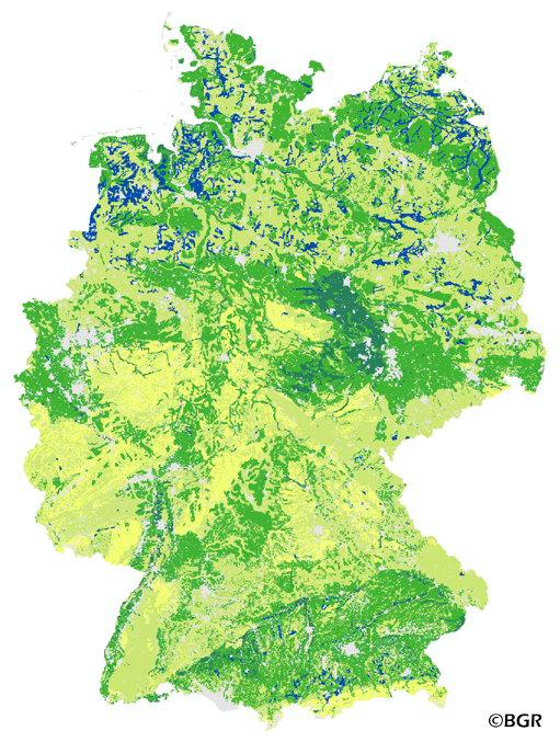
Field capacity of German soils
The map of the field capacity of soils in Germany gives an overview of the amount of water which can be stored in a soil (depth 1 m). The water storage capacity is a key function of soils. The field capacity was derived from the landuse stratified soil map of Germany at scale 1:1,000,000. The method is published in the Bodenkundliche Kartieranleitung KA4 (1994) and in the documentation of Ad-hoc-AG Boden (representing the soil experts of the geological services of the German federal states). The land use information is derived from the CORINE Land Cover data set (2006).
|
|
Citation proposal
(2015) . Field capacity of German soils. http://gdk-inspire-1.ffm.gdi-de.org/geonetwork/srv/api/records/1f9cac1e-ac71-4007-bec1-bdf979fa4403 |
Simple
- Alternate title
- FK10dm1000_250
- Date ( Creation )
- 2014-06-20
- Date ( Publication )
- 2015-08-03
- Edition
- Version 1.0
- Identifier
- 5a75335e-ba46-452f-8792-ac7e9b49da88
Author
- Status
- completed Completed
Point of contact
Bundesanstalt für Geowissenschaften und Rohstoffe (BGR)
-
Stegger, Ulrich
Stilleweg 2
Hannover
30655
DE
- GEMET - Concepts, version 2.4 ( Theme )
-
- Boden
- Bodenkarte
- Bodenwasser
- Bodenwasserhaushalt
- GEMET - INSPIRE themes, version 1.0 ( Theme )
-
- Boden
- Soil
- Freies Schlagwort ( Theme )
-
- Feldkapazität
- Wasserspeicherfähigkeit
- inspireidentifiziert
- opendata
- Keywords ( Place )
-
- Bundesrepublik Deutschland
- Spatial scope
-
- National
- High-value dataset categories
-
- Erdbeobachtung und Umwelt
- Access constraints
- Other restrictions
- Use constraints
- Other restrictions
- Other constraints
- Allgemeine Geschäftsbedingungen, siehe https://www.bgr.bund.de/AGB - General terms and conditions, see https://www.bgr.bund.de/AGB_en. Die bereitgestellten Informationen sind bei Weiterverwendung wie folgt zu zitieren: Datenquelle: FK10dm1000_250 V1.0, (c) BGR, Hannover, 2015.
- Other constraints
- Dieser Datensatz kann gemäß der "Nutzungsbestimmungen für die Bereitstellung von Geodaten des Bundes" (https://sg.geodatenzentrum.de/web_public/gdz/lizenz/geonutzv.pdf) genutzt werden.
- Other constraints
- {"id": "geoNutz/20130319", "name": "Nutzungsbestimmungen für die Bereitstellung von Geodaten des Bundes", "url": "https://sg.geodatenzentrum.de/web_public/gdz/lizenz/geonutzv.pdf", "quelle": "FK10dm1000_250 V1.0, (c) BGR, Hannover, 2015"}
- Spatial representation type
- Grid
- Denominator
- 1000000
- Metadata language
- German
- Character set
- UTF8
- Topic category
-
- Geoscientific information
N
S
E
W
))
- Geographic identifier
- Regionalschlüssel / 000000000000
- Distribution format
-
- georef. TIFF (n/a )
- Transfer size
- 5
- OnLine resource
-
FK10dm1000_250 (georef. TIFF)
FK10dm1000_250 im Format georeferenziertes TIFF
- OnLine resource
- Website zum Thema
- OnLine resource
-
Karte im BGR-Geoviewer
Karte im BGR-Geoviewer
- Hierarchy level
- Dataset
Conformance result
- Date ( Publication )
- 2010-12-08
- Explanation
- siehe dazu die angegebene Durchführungsbestimmung
- Statement
- Bodendaten aus BÜK1000N V2.31 (BGR), Landnutzungsdaten aus Corine Land Cover 2006 (UBA/DLR).
gmd:MD_Metadata
- File identifier
- 1f9cac1e-ac71-4007-bec1-bdf979fa4403 XML
- Metadata language
- German
- Character set
- UTF8
- Hierarchy level
- Dataset
- Hierarchy level name
- Boden
- Date stamp
- 2025-03-12
- Metadata standard name
- INSPIRE Metadata Implementing Rules: Technical Guidelines based on EN ISO 19115 and EN ISO 19119
- Metadata standard version
- n/a
Point of contact
Overviews
Provided by

Views
1f9cac1e-ac71-4007-bec1-bdf979fa4403
Access to the portal
Read here the full details and access to the data.
Associated resources
Not available