 INSPIRE-1
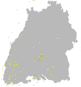
LGRB-BW INSPIRE LED: Gespürte Erdbeben seit 1994 (Natural Risk Zone: Observed Events) - Datensatz
Die Ebene der gespürten Erdbeben enthält einen Auszug aus den Ebenen "tektonische Erdbeben" und "induzierte Erdbeben". Dargestellt werden Erdbeben seit 1994, die in Baden-Württemberg gespürt wurden, d.h. für die eine maximale Intensität (nicht zu verwechseln mit der Magnitude) auf der Europäischen Makroseismischen Skala (EMS-98, früher auch andere Skalen) angegeben werden kann.
|
|
Citation proposal
. LGRB-BW INSPIRE LED: Gespürte Erdbeben seit 1994 (Natural Risk Zone: Observed Events) - Datensatz. http://gdk-inspire-1.ffm.gdi-de.org/geonetwork/srv/api/records/22485d95-a0fd-4fc7-a7c1-e4a6244efb8b |
INSPIRE
Identification
- File identifier
- 22485d95-a0fd-4fc7-a7c1-e4a6244efb8b XML
- Hierarchy level
- Dataset
Online resource
Resource identifier
- Metadata language
- German
- Spatial representation type
- Vector
Encoding
- Format
- ESRI Shapefile
- Version
- n/a (default)
- Specification
- https://www.esri.com/content/dam/esrisites/sitecore-archive/Files/Pdfs/library/whitepapers/pdfs/shapefile.pdf
Projection
Classification of data and services
- Topic category
-
- Geoscientific information
- Environment
Classification of data and services
Coupled resource
Coupled resource
Classification of data and services
Coupled resource
Coupled resource
Keywords
- Liste der Datenkategorien in der GDI-BW für Geodaten
-
- inspireidentifiziert
- GEMET - INSPIRE themes, version 1.0 ( Theme )
- Spatial scope
- GDI-BW-Schlüsselwortliste nach dem mehrsprachigen Umwelt-Thesaurus GEMET
-
- Geologie
- Monitoring
Other keywords
- Keywords
-
- Erdbeben
Geographic coverage
N
S
E
W
))
Temporal reference
Temporal extent
Temporal extent
- Date ( Revision )
- 2022-10-01
Quality and validity
- Lineage
- Erdbebenkatalog von Baden-Württemberg
- Denominator
- 350000
Conformity
Conformity
Conformity
Conformity
Conformity
Conformity
Restrictions on access and use
Restrictions on access and use
Responsible organization (s)
Contact for the resource
- Organisation name
- Regierungspräsidium Freiburg - Abteilung 9 Landesamt für Geologie, Rohstoffe und Bergbau, Ref. 98 Landeserdbebendienst
- abteilung9@rpf.bwl.de
Responsible organization (s)
Contact for the resource
- Organisation name
- Regierungspräsidium Freiburg - Abteilung 9 Landesamt für Geologie, Rohstoffe und Bergbau, Ref. 98 Landeserdbebendienst
- abteilung9@rpf.bwl.de
Metadata information
Contact for the metadata
- Organisation name
- Regierungspräsidium Freiburg - Abteilung 9 Landesamt für Geologie, Rohstoffe und Bergbau, Referat 91 Geowissenschaftliches Landeservicezentrum
- abteilung9@rpf.bwl.de
- Organisation name
- Regierungspräsidium Freiburg - Abteilung 9 Landesamt für Geologie, Rohstoffe und Bergbau, Referat 91 Geowissenschaftliches Landeservicezentrum
- abteilung9@rpf.bwl.de
- Date stamp
- 2023-05-23T09:48:46
- Metadata language
- German
- Character set
- UTF8
SDS
Conformance class 1: invocable
Access Point URL
Endpoint URL
Technical specification
Conformance class 2: interoperable
Coordinate reference system
Quality of Service
Access constraints
Limitation
Use constraints
Limitation
Responsible custodian
Contact for the resource
Conformance class 3: harmonized
Overviews
thumbnail
Provided by

Views
22485d95-a0fd-4fc7-a7c1-e4a6244efb8b
Access to the portal
Read here the full details and access to the data.
Associated resources
Not available