 POC 3.12
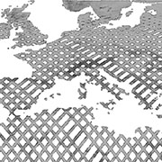
SRTM X-SAR - Hillshade Mosaic - Global
The SRTM X-SAR Hillshade Mosaic is a greyscale shaded relief based on the SRTM X-SAR Elevation Mosaic. Combined with the latter, it can be used to add a 3d effect and enhance the visual resolution by pronouncing peaks and valleys.
- Identification
- Distribution
- Quality
- Spatial rep.
- Ref. system
- Content
- Portrayal
- Metadata
- Md. constraints
- Md. maintenance
- Schema info
Identification
Data identification
Citation
- Date (Revision)
- 2011-01-31T00:22:00
- Identifier
- https://geoservice.dlr.de/catalogue/srv/metadata/2a65b12a-7dab-4724-879f-e4eb198ee542
- Presentation form
- Digital map
- Purpose
-
The purpose of the SRTM X-SAR Hillshade Mosaic is to enable and facilitate access to and visualisation of DLR's SRTM data through standardized web services.
- Status
- Completed
- Maintenance and update frequency
- As needed
- Theme
-
-
DLR
-
Elevation
-
Space Shuttle
-
STS-99
-
SRTM
-
X-SAR
-
Hillshade
-
Global
-
inspireidentifiziert
-
-
GEMET - INSPIRE themes, version 1.0
-
-
Höhe
-
Legal constraints
- Access constraints
- Other restrictions
- Other constraints
- Es gelten keine Zugriffsbeschränkungen
Legal constraints
- Use constraints
- Other restrictions
- Other constraints
-
Nutzungsbedingungen: https://geoservice.dlr.de/resources/licenses/srtm_xsar/DLR_SRTM_XSAR_ReadMe.pdf / Terms of use: https://geoservice.dlr.de/resources/licenses/srtm_xsar/DLR_SRTM_XSAR_ReadMe.pdf
- Use limitation
-
Nutzungseinschränkungen: Das DLR ist nicht haftbar für Schäden, die sich aus der Nutzung ergeben. / Use Limitations: DLR not liable for damage resulting from use.
- Spatial representation type
- Grid
- Denominator
- 50000
- Metadata language
- Deutsch
- Character set
- UTF8
- Topic category
-
- Elevation
Extent
))
- Begin date
- 2000-01-11T00:00:00
- End date
- 2000-01-22T00:00:00
Distribution
Distribution
- Distribution format
-
-
GeoTIFF
()
-
GeoTIFF
()
Digital transfer options
- OnLine resource
-
DLR SRTM Webpage
(
WWW:LINK-1.0-http--link
)
Webpage with links and mission descriptions
- OnLine resource
-
srtm_x-sar_hillshade_mosaic
(
OGC:WMS
)
WMS access to SRTM X-SAR Hillshade Mosaic
- OnLine resource
-
srtm_x-sar_hillshade_mosaic
(
OGC:WCS
)
WCS access to SRTM X-SAR Hillshade Mosaic
- OnLine resource
- https://geoservice.dlr.de/eoc/elevation/wms?SERVICE=WMS&REQUEST=GetCapabilities ( OGC:WMS-http-get-capabilities )
- OnLine resource
- https://geoservice.dlr.de/eoc/elevation/wcs?SERVICE=WCS&REQUEST=GetCapabilities ( OGC:WCS-http-get-capabilities )
- OnLine resource
-
EOC Geoservice Map Context
(
WWW:LINK-1.0-http--link
)
EOC Geoservice Map Context (srtm:x-sar)
Quality
Data quality
- Hierarchy level
- Dataset
Domain consistency
- Measure identification
- INSPIRE / Conformity_001
Conformance result
Citation
- Date (Publication)
- 2010-12-08
- Explanation
-
See the referenced specification.
- Pass
- Yes
Lineage
- Statement
-
Horizontal accuracy (absolute): ±20m 90% circular error
Horizontal accuracy (relative): ±15m 90% circular error
Vertical accuracy (absolute): ±16m 90% linear error
Vertical accuracy (relative): ±6m 90% linear error
Process step
- Description
-
Calculation of a list of files that are contained in each 30x30 degree tile of the world grid
- Date / Time
- 2010-07-31T09:00:00
Process step
- Description
-
Calculation of the overviews for each GeoTIFF tile. The following GDAL v1.7.2 command was used: gdaladdo -r cubic GEOTIFF_FILE 4 8 16 32 64 128 256 512 1024
- Date / Time
- 2010-01-01T18:00:00
Spatial rep.
Grid spatial representation
- Number of dimensions
- 3
Dimension
- Dimension name
- Row
- Dimension size
- 1598400
- Resolution
- 25 m
Dimension
- Dimension name
- Column
- Dimension size
- 510600
- Resolution
- 25 m
Dimension
- Dimension name
- Vertical
- Dimension size
- 1
- Resolution
- 1 m
- Cell geometry
- Area
- Transformation parameter availability
- No
Ref. system
- Unique resource identifier
- EPSG:4326
Metadata
Metadata
- File identifier
- 2a65b12a-7dab-4724-879f-e4eb198ee542 XML
- Metadata language
- Deutsch
- Character set
- UTF8
- Hierarchy level
- Dataset
- Hierarchy level name
-
dataset
- Date stamp
- 2023-01-25T09:42:02
- Metadata standard name
-
ISO 19115-1:2014/19139
- Metadata standard version
-
1.0
Overviews

Spatial extent
Provided by
