 POC 3.12
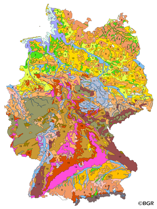
Soil Map of the Federal Republic of Germany 1:5,000,000 (WMS)
Web Map Service (WMS) der BÜK5000. Die hier vorgestellte Bodenübersichtskarte im Maßstab 1:5.000.000 wurde durch eine weitere inhaltliche und räumliche Zusammenfassung aus den Legendeneinheiten der BÜK1000N abgeleitet. Diese Zusammenfassung orientierte sich an den Angaben zu den Bodenausgangsgesteinen und führte zu 20 bodenkundlichen (23) Legendeneinheiten mit Kartenpolygonen von mindestens 64 Quadratkilometern Größe.
Web Map Service (WMS) of the BUK5000. The BUEK5000 is derived form the landuse stratified soil map of Germany at scale 1:1,000,000 by aggregation, focused on information about the parent material, and generalization. The maps shows 20 soil (23) legend units with polygons of at least 64 square kilometers.
- Identification
- Distribution
- Quality
- Spatial rep.
- Ref. system
- Content
- Portrayal
- Metadata
- Md. constraints
- Md. maintenance
- Schema info
Identification
Identification info
Service Identification (19119)
Citation
- Alternate title
-
BÜK5000 (WMS)
- Date (Publication)
- 2006-01-01
- Date (Revision)
- 2003-01-01
- Identifier
- 514cd7da-4fb8-4467-96a0-c805c4d8ba8c
- Status
- Completed
-
GEMET - INSPIRE themes, version 1.0
-
-
Boden
-
soil
-
-
GEMET - Concepts, version 2.4
-
-
Bodenart
-
Bodenkarte
-
Bodenkunde
-
Bodenschutz
-
Umweltschutz
-
- Theme
-
-
Bodenausgangsgesteine
-
Bodeneigenschaften
-
Bodenform
-
Bodengesellschaft
-
Bodeninformationssystem
-
Bodensubstrat
-
Bodensystematik
-
Bodenübersichtskarte
-
Fachinformationssystem
-
Geografisches Informationssystem
-
infoMapAccessService
-
inspireidentifiziert
-
WMS
-
opendata
-
- Place
-
-
Bundesrepublik Deutschland
-
-
Spatial scope
-
-
National
-
Legal constraints
- Access constraints
- Other restrictions
- Other constraints
- Es gelten keine Zugriffsbeschränkungen
Legal constraints
- Use constraints
- Other restrictions
- Other constraints
-
Allgemeine Geschäftsbedingungen, siehe https://www.bgr.bund.de/AGB - General terms and conditions, see https://www.bgr.bund.de/AGB_en. Die bereitgestellten Informationen sind bei Weiterverwendung wie folgt zu zitieren: Datenquelle: BÜK5000 V3.0, (C) BGR, Hannover, 2005.
- Other constraints
-
Dieser Datensatz kann gemäß der "Nutzungsbestimmungen für die Bereitstellung von Geodaten des Bundes" ( https://sg.geodatenzentrum.de/web_public/gdz/lizenz/geonutzv.pdf) genutzt werden.
- Other constraints
-
Dieser Datensatz kann gemäß der "Nutzungsbestimmungen für die Bereitstellung von Geodaten des Bundes" ( https://sg.geodatenzentrum.de/web_public/gdz/lizenz/geonutzv.pdf) genutzt werden.
- Service Type
- view
- Service Version
-
OGC:WMS 1.3.0
))
Coupled Resource
- Operation Name
-
getMap
- Identifier
-
26FA8698-FC0B-4ADA-B8D6-9916B7DA8029
- Coupling Type
- Tight
Contains Operations
- Operation Name
-
GetCapabilities
- Distributed Computing Platforms
- Web services
- Connect Point
- https://services.bgr.de/wms/boden/buek5000/?
Contains Operations
- Operation Name
-
GetMap
- Distributed Computing Platforms
- Web services
- Connect Point
- https://services.bgr.de/wms/boden/buek5000/?
- Operates On
Distribution
Distribution
- Distribution format
-
-
png
(
n/a
)
-
jpeg
(
n/a
)
-
gif
(
n/a
)
-
png
(
n/a
)
- OnLine resource
- https://services.bgr.de/wms/boden/buek5000/?REQUEST=GetCapabilities&SERVICE=wms&VERSION=1.3.0
- OnLine resource
- Karte im BGR-Geoviewer
Quality
Data quality
Scope
- Hierarchy level
- Service
- Other
-
Service
Conformance result
Citation
- Date (Publication)
- 2009-10-20
- Explanation
-
siehe dazu die angegebene Durchführungsbestimmung
- Statement
-
BÜK1000N 2.3, BAG5000 3.0.
Ref. system
- Unique resource identifier
- EPSG:3035
Metadata
Metadata
- File identifier
- 31431A40-6BB3-4D79-806A-83BBF869BE69 XML
- Metadata language
- Deutsch
- Character set
- UTF8
- Hierarchy level
- Service
- Hierarchy level name
-
Boden
- Date stamp
- 2020-07-22
- Metadata standard name
-
INSPIRE Metadata Implementing Rules: Technical Guidelines based on EN ISO 19115 and EN ISO 19119
- Metadata standard version
-
n/a
Overviews
Spatial extent
Provided by
