 INSPIRE-1
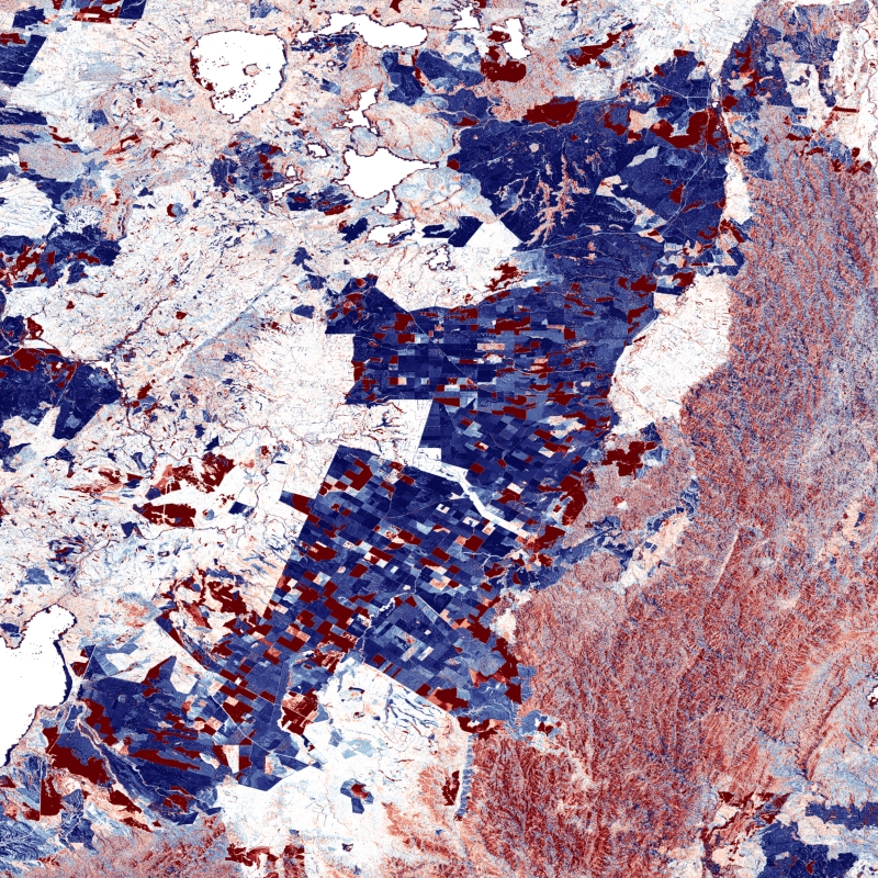
TanDEM-X - DEM Change Maps (DCM) - Global, 30m
The TanDEM-X DEM Change Maps is a project developed by the Institute Remote Sensing Technology (IMF) at the German Aerospace Center (DLR) within the activities of the TanDEM-X Mission.
Between 2016 and 2022, the TanDEM-X mission acquired an additional complete coverage of the Earth's landmass to deliver a temporally independent coverage within a well-defined time span. These new acquisitions not only provide more up-to-date elevation information, but also a great dataset to show the changes that have occurred during the years separating this new coverage from the coverages acquired to generate the TanDEM-X global DEM (between 2011 and 2014). This product - the TanDEM-X 30 m DEM Change Maps - shows the changes between the edited first global TanDEM-X DEM (TanDEM-X 30m Edited DEM) and the newly acquired time-tagged DEM scenes. In order to keep a unique timestamp, two change maps are available per tile: one with the change to the oldest pixel in the new dataset - the first DEM change, and another with the change to the newest pixel of the new dataset - the last DEM change. The two maps differ only when there are multiple coverages.
Users must be aware that a given elevation change measured in the DEM change maps corresponds to a topographic change with respect to TanDEM-X 30m EDEM, but cannot be associated with a corresponding physical height change of the same magnitude. This is due to the fact that the global TanDEM-X DEM reflects an averaged elevation derived from the combination of different images, acquired over a period of several years but also because the radar waves penetrate differently in the surface depending on the attributes of the land cover. This is especially important over vegetated and snow-covered regions.
|
|
Citation proposal
. TanDEM-X - DEM Change Maps (DCM) - Global, 30m. http://gdk-inspire-1.ffm.gdi-de.org/geonetwork/srv/api/records/3427bcdb-837f-4269-ab62-93b6864b2865 |
Simple
- Date ( Creation )
- 2023-11-17T10:00:00
- Presentation form
- Digital map
- Status
- Completed
Point of contact
Distributor
- Maintenance and update frequency
- As needed
- Keywords
-
- DLR
- IMF
- EOC
- TanDEM-X
- DEM Change Maps
- Change
- Change Detection
- Digital Elevation Model
- TDM 30m DCM
- TanDEM-X 4D
- TDX-1
- TSX-1
- Global
- inspireidentifiziert
- GEMET - INSPIRE themes, version 1.0 ( Theme )
-
- Elevation
- Spatial scope ( Place )
- Use limitation
- Nutzungseinschränkungen: Das DLR ist nicht haftbar für Schäden, die sich aus der Nutzung ergeben. / Use Limitations: DLR not liable for damage resulting from use.
- Access constraints
- Other restrictions
- Use constraints
- Other restrictions
- Other constraints
- Nutzungsbedingungen: https://geoservice.dlr.de/resources/licenses/tdm30-edited/License_for_the_Utilization_of_TanDEM-X_30m-EDEM_DCM_for_Scientific_Use.pdf Terms of Use: https://geoservice.dlr.de/resources/licenses/tdm30-edited/License_for_the_Utilization_of_TanDEM-X_30m-EDEM_DCM_for_Scientific_Use.pdf
- Spatial representation type
- Grid
- Denominator
- 60000
- Metadata language
- German
- Character set
- UTF8
- Topic category
-
- Elevation
))
- Number of dimensions
- 3
- Dimension name
- Column
- Dimension size
- 1296000
- Resolution
- 30 m
- Dimension name
- Row
- Dimension size
- 648000
- Resolution
- 30 m
- Dimension name
- Vertical
- Dimension size
- 1
- Resolution
- 1 m
- Cell geometry
- Area
- Transformation parameter availability
- false
- Distribution format
-
- GeoTIFF ()
- OnLine resource
-
TanDEM-X DEM access - scientific users
Webpage with links and description for accessing TanDEM-X elevation models for scientific users.
- OnLine resource
-
TanDEM-X DEM access - non-scientific users
Webpage for accessing/ordering TanDEM-X elevation models for non-scientific users.
- OnLine resource
-
EOC Geoservice Map Context
EOC Geoservice Map Context (tdm:dcm30)
- OnLine resource
-
EOC Download Service
TanDEM-X Change Maps - EOC Download Service
- OnLine resource
-
TDM30_DCM_DCMFIRST
WMS Access: DCM30 DEM Change Maps (DCM) - First change 16-22
- OnLine resource
-
TDM30_DCM_DCMLAST
WMS Access: DCM30 DEM Change Maps (DCM) - Last change 16-22
- OnLine resource
-
TDM30_DCM_CIMFIRST
WMS Access: DCM30 Change Indication Mask (CIM) - First change 16-22
- OnLine resource
-
TDM30_DCM_CIMLAST
WMS Access: DCM30 Change Indication Mask (CIM) - Last change 16-22
- OnLine resource
-
TDM30_DCM_DATEFIRST
WMS Access: DCM30 Date (DATE) - First change 16-22
- OnLine resource
-
TDM30_DCM_DATELAST
WMS Access: DCM30 Date (DATE) - Last change 16-22
- OnLine resource
-
TDM30_DCM_HAIFIRST
WMS Access: DCM30 Height Accuracy Indication (HAI) - First change 16-22
- OnLine resource
-
TDM30_DCM_HAILAST
WMS Access: DCM30 Height Accuracy Indication (HAI) - Last change 16-22
- OnLine resource
-
TDM30 - EOC Geoservice Data Guide
EOC Geoservice Data Guide
- Hierarchy level
- Dataset
Domain consistency
- Measure identification
- INSPIRE / Conformity_001
Conformance result
- Date ( Publication )
- 2010-12-08
- Explanation
- See the referenced specification.
- Pass
- true
- Statement
- For operational TanDEM-X acquisitions single DEM scenes with an extend of ~30km x 50km are generated by applying bistatic focusing, processing of individual interferograms, phase unwrapping and geocoding. The in-house edited DEMs are used to ease phase unwrapping and pre-calibrate the scenes.
- Description
-
DEM Change Maps Processor (DCMP) Processing:
Each Change Raw DEM processed by the ITP is automatically passed to the DEM Change Map Processor (DCMP). These Change Raw DEMs (originally in 6m posting) are first downsampled to 30m posting. Then, they are fine calibrated per datatake and mosaicked to a temporary DEM. This one is then compared to the edited TanDEM-X DEM to generate the DEM Change Maps.
- Description
-
Quality Assurance:
Used Change Raw DEMs were automatically processed using the ITP which has an automated quality check. These Change Raw DEMs are calibrated to the reference DEM during the processing and therefore only final calibration check is done over a datatake during the generation of the DEM Change Maps. This calibration as well as other possible artefacts coming from e.g. the TanDEM-X 30m Edited DEM used to compute the DCM were visually checked and flags were assigned manually by operators. Changes are assessed automatically during the DCM generation depending on at least Height Accuracy Indicator and the actual change height.
gmd:MD_Metadata
- File identifier
- 3427bcdb-837f-4269-ab62-93b6864b2865 XML
- Metadata language
- English
- Character set
- UTF8
- Hierarchy level
- Dataset
- Hierarchy level name
- dataset
- Date stamp
- 2024-06-27T14:43:50
- Metadata standard name
- 19115-1:2014/19139
- Metadata standard version
- 1.0
Point of contact
Overviews

Provided by
