 INSPIRE-1
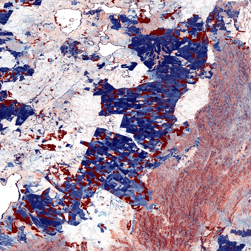
TanDEM-X - DEM Change Maps (DCM) - Global, 30m
The TanDEM-X DEM Change Maps is a project developed by the Institute Remote Sensing Technology (IMF) at the German Aerospace Center (DLR) within the activities of the TanDEM-X Mission.
Between 2016 and 2022, the TanDEM-X mission acquired an additional complete coverage of the Earth's landmass to deliver a temporally independent coverage within a well-defined time span. These new acquisitions not only provide more up-to-date elevation information, but also a great dataset to show the changes that have occurred during the years separating this new coverage from the coverages acquired to generate the TanDEM-X global DEM (between 2011 and 2014). This product - the TanDEM-X 30 m DEM Change Maps - shows the changes between the edited first global TanDEM-X DEM (TanDEM-X 30m Edited DEM) and the newly acquired time-tagged DEM scenes. In order to keep a unique timestamp, two change maps are available per tile: one with the change to the oldest pixel in the new dataset - the first DEM change, and another with the change to the newest pixel of the new dataset - the last DEM change. The two maps differ only when there are multiple coverages.
Users must be aware that a given elevation change measured in the DEM change maps corresponds to a topographic change with respect to TanDEM-X 30m EDEM, but cannot be associated with a corresponding physical height change of the same magnitude. This is due to the fact that the global TanDEM-X DEM reflects an averaged elevation derived from the combination of different images, acquired over a period of several years but also because the radar waves penetrate differently in the surface depending on the attributes of the land cover. This is especially important over vegetated and snow-covered regions.
|
|
Citation proposal
. TanDEM-X - DEM Change Maps (DCM) - Global, 30m. http://gdk-inspire-1.ffm.gdi-de.org/geonetwork/srv/api/records/3427bcdb-837f-4269-ab62-93b6864b2865 |
INSPIRE
Identification
- File identifier
- 3427bcdb-837f-4269-ab62-93b6864b2865 XML
- Hierarchy level
- Dataset
Online resource
- Protocol
- WWW:LINK-1.0-http--link
- Protocol
- WWW:LINK-1.0-http--link
- Protocol
- WWW:LINK-1.0-http--link
- Protocol
- WWW:LINK-1.0-http--link
- Protocol
- OGC:WMS
- Protocol
- OGC:WMS
- Protocol
- OGC:WMS
- Protocol
- OGC:WMS
- Protocol
- OGC:WMS
- Protocol
- OGC:WMS
- Protocol
- OGC:WMS
- Protocol
- OGC:WMS
- Protocol
- WWW:LINK-1.0-http--link
Resource identifier
- Metadata language
- German
- Spatial representation type
- Grid
Encoding
- Format
- GeoTIFF
Projection
Classification of data and services
- Topic category
-
- Elevation
Classification of data and services
Coupled resource
Coupled resource
Classification of data and services
Coupled resource
Coupled resource
Keywords
- GEMET - INSPIRE themes, version 1.0 ( Theme )
-
- Elevation
- Spatial scope ( Place )
Other keywords
- Keywords
-
- DLR
- IMF
- EOC
- TanDEM-X
- DEM Change Maps
- Change
- Change Detection
- Digital Elevation Model
- TDM 30m DCM
- TanDEM-X 4D
- TDX-1
- TSX-1
- Global
- inspireidentifiziert
Geographic coverage
))
Temporal reference
Temporal extent
Temporal extent
- Date ( Creation )
- 2023-11-17T10:00:00
Quality and validity
- Lineage
- For operational TanDEM-X acquisitions single DEM scenes with an extend of ~30km x 50km are generated by applying bistatic focusing, processing of individual interferograms, phase unwrapping and geocoding. The in-house edited DEMs are used to ease phase unwrapping and pre-calibrate the scenes.
- Denominator
- 60000
Conformity
Conformity
Conformity
Conformity
Conformity
Conformity
- Explanation
- See the referenced specification.
Restrictions on access and use
- Access constraints
- Nutzungsbedingungen: https://geoservice.dlr.de/resources/licenses/tdm30-edited/License_for_the_Utilization_of_TanDEM-X_30m-EDEM_DCM_for_Scientific_Use.pdf Terms of Use: https://geoservice.dlr.de/resources/licenses/tdm30-edited/License_for_the_Utilization_of_TanDEM-X_30m-EDEM_DCM_for_Scientific_Use.pdf
Restrictions on access and use
Responsible organization (s)
Contact for the resource
- Organisation name
- German Aerospace Center (DLR)
- tandemx-science@dlr.de
- Organisation name
- German Aerospace Center (DLR)
- geoservice@dlr.de
Responsible organization (s)
Contact for the resource
- Organisation name
- German Aerospace Center (DLR)
- tandemx-science@dlr.de
- Organisation name
- German Aerospace Center (DLR)
- geoservice@dlr.de
Metadata information
Contact for the metadata
- Organisation name
- German Aerospace Center (DLR)
- geoservice@dlr.de
- Date stamp
- 2024-06-27T14:43:50
- Metadata language
- English
- Character set
- UTF8
SDS
Conformance class 1: invocable
Access Point URL
Endpoint URL
Technical specification
Conformance class 2: interoperable
Coordinate reference system
Quality of Service
Access constraints
Limitation
Use constraints
Limitation
Responsible custodian
Contact for the resource
Conformance class 3: harmonized
Overviews

Provided by
