 INSPIRE-1
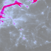
Sentinel-5P TROPOMI Surface Nitrogendioxide (NO2), Level 4 – Regional (Germany and neighboring countries)
The TROPOMI instrument onboard the Copernicus SENTINEL-5 Precursor satellite is a nadir-viewing, imaging spectrometer that provides global measurements of atmospheric properties and constituents on a daily basis. It is contributing to monitoring air quality and climate, providing critical information to services and decision makers.
The instrument uses passive remote sensing techniques by measuring the top of atmosphere solar radiation reflected by and radiated from the earth and its atmosphere. The four spectrometers of TROPOMI cover the ultraviolet (UV), visible (VIS), Near Infra-Red (NIR) and Short Wavelength Infra-Red (SWIR) domains of the electromagnetic spectrum. The operational trace gas products generated at DLR on behave ESA are: Ozone (O3), Nitrogen Dioxide (NO2), Sulfur Dioxide (SO2), Formaldehyde (HCHO), Carbon Monoxide (CO) and Methane (CH4), together with clouds and aerosol properties.
This product displays the Nitrogen Dioxide (NO2) near surface concentration for Germany and neighboring countries as derived from the POLYPHEMUS/DLR air quality model. Surface NO2 is mainly generated by anthropogenic sources, e.g. transport and industry.
POLYPHEMUS/DLR is a state-of-the-art air quality model taking into consideration
- meteorological conditions,
- photochemistry,
- anthropogenic and natural (biogenic) emissions,
- TROPOMI NO2 observations for data assimilation.
This Level 4 air quality product (surface NO2 at 15:00 UTC) is based on innovative algorithms, processors, data assimilation schemes and operational processing and dissemination chain developed in the framework of the INPULS project. The DLR project INPULS develops (a) innovative retrieval algorithms and processors for the generation of value-added products from the atmospheric Copernicus missions Sentinel-5 Precursor, Sentinel-4, and Sentinel-5, (b) cloud-based (re)processing systems, (c) improved data discovery and access technologies as well as server-side analytics for the users, and (d) data visualization services.
|
|
Citation proposal
. Sentinel-5P TROPOMI Surface Nitrogendioxide (NO2), Level 4 – Regional (Germany and neighboring countries). http://gdk-inspire-1.ffm.gdi-de.org/geonetwork/srv/api/records/40e3e081-4f13-4e9d-a484-4c39a3f5987e |
Simple
- Date ( Creation )
- 2023-12-11T10:00:00
- Presentation form
- Digital map
- Status
- ongoing
Point of contact
Distributor
- Maintenance and update frequency
- Daily
- Keywords
-
- DLR
- EOC
- inspireidentifiziert
- Sentinel-5P
- TROPOMI
- Polyphemus/DLR
- Atmosphere
- Surface Nitrogendioxide (NO2)
- Daily
- Level 4
- opendata
- GEMET - INSPIRE themes, version 1.0 ( Theme )
- Spatial scope ( Theme )
- Use limitation
- Nutzungseinschränkungen: Das DLR ist nicht haftbar für Schäden, die sich aus der Nutzung ergeben. / Use Limitations: DLR not liable for damage resulting from use.
- Access constraints
- Other restrictions
- Use constraints
- Other restrictions
- Other constraints
- Nutzungsbedingungen: Lizenz, https://creativecommons.org/licenses/by/4.0 / Terms of use: License, https://creativecommons.org/licenses/by/4.0
- Other constraints
-
{"id": "cc-by-4.0",
"name": "Creative Commons Namensnennung - 4.0 International (CC BY 4.0)",
"url": "http://dcat-ap.de/def/licenses/cc-by/4.0",
"quelle": "Copyright DLR (2023)"}
- Spatial representation type
- Grid
- Denominator
- 7000000
- Metadata language
- German
- Character set
- UTF8
- Topic category
-
- Climatology, meteorology, atmosphere
))
- Distribution format
-
- GeoTIFF ()
- OnLine resource
-
Atmos - TROPOMI / S5P Webpage
Project Website
- OnLine resource
-
TROPOMI / S5P L4 related datasets
S5P L4 all datasets
- OnLine resource
-
EOC Geoservice Map Context
EOC Geoservice Map Context (s5p:tropomi:l4)
- OnLine resource
-
EOC Download Service
Sentinel-5p Tropomi L4 Download Service - EOC Download Service
- OnLine resource
-
S5P_TROPOMI_L4_P1D_NO2surf
WMS Access: S5P L4 Surface Nitrogendioxide (NO2)
- OnLine resource
-
S5P_TROPOMI_L4_P1D_NO2surf
EOC STAC Collection
- Hierarchy level
- Series
Domain consistency
- Measure identification
- INSPIRE / Conformity_001
Conformance result
- Date ( Publication )
- 2010-12-08
- Explanation
- See the referenced specification.
- Pass
- true
- Statement
- The input data for the L4 product is the Sentinel-5P TROPOMI NRT Level 2 product "S5P_NRTI_L2__NO2__"
- Description
-
Processing:
Data assimilation (Optimal Interpolation) of S5P TropOMI tropospheric NO2 columns into chemical dispersion model Polyphemus/DLR for Germany and neighbor countries. S5P L2 data is filtered for outliers, original accuracy error and quality flags are used. OI applies parametrized Gaussian covariances. Observation operator is preprocessed based on available observations. Processing is parallelized for scaling with CPUs and threads.
Quality Assurance:
First-guess errors, analysis errors and S5p data coverage are monitored on a daily base https://wdc.dlr.de/data_lib/S5P/TROPOMI/L4/LATEST/S5P_NRT_OI.errs.svg
gmd:MD_Metadata
- File identifier
- 40e3e081-4f13-4e9d-a484-4c39a3f5987e XML
- Metadata language
- English
- Character set
- UTF8
- Hierarchy level
- Series
- Hierarchy level name
- Dataseries
- Date stamp
- 2024-06-20T13:07:50
- Metadata standard name
- 19115-1:2014/19139
- Metadata standard version
- 1.0
Point of contact
Overviews

Provided by
