 INSPIRE-1
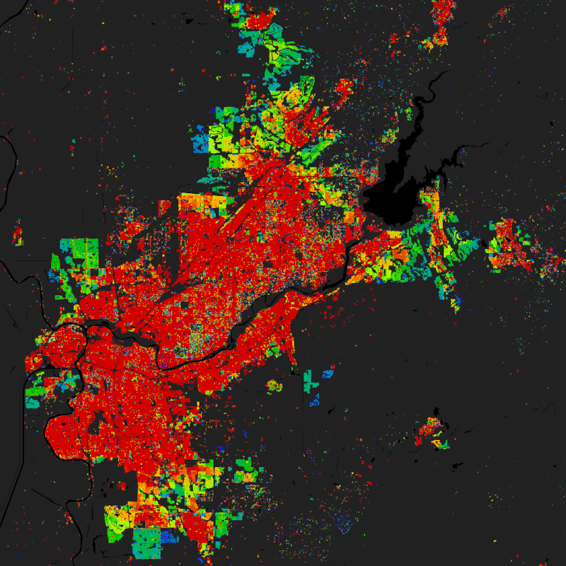
World Settlement Footprint (WSF) Evolution - Landsat-5/-7 - Global
The World Settlement Footprint (WSF) 2019 is a 10m resolution binary mask outlining the extent of human settlements globally derived by means of 2019 multitemporal Sentinel-1 (S1) and Sentinel-2 (S2) imagery. Based on the hypothesis that settlements generally show a more stable behavior with respect to most land-cover classes, temporal statistics are calculated for both S1- and S2-based indices. In particular, a comprehensive analysis has been performed by exploiting a number of reference building outlines to identify the most suitable set of temporal features (ultimately including 6 from S1 and 25 from S2). Training points for the settlement and non-settlement class are then generated by thresholding specific features, which varies depending on the 30 climate types of the well-established Köppen Geiger scheme. Next, binary classification based on Random Forest is applied and, finally, a dedicated post-processing is performed where ancillary datasets are employed to further reduce omission and commission errors. Here, the whole classification process has been entirely carried out within the Google Earth Engine platform. To assess the high accuracy and reliability of the WSF2019, two independent crowd-sourcing-based validation exercises have been carried out with the support of Google and Mapswipe, respectively, where overall 1M reference labels have been collected based photointerpretation of very high-resolution optical imagery.
Starting backwards from the year 2015 - for which the WSF2015 is used as a reference - settlement and non-settlement training samples for the given target year t are iteratively extracted by applying morphological filtering to the settlement mask derived for the year t+1, as well as excluding potentially mislabeled samples by adaptively thresholding the temporal mean NDBI, MNDWI and NDVI. Finally, binary Random Forest classification in performed.
To quantitatively assess the high accuracy and reliability of the dataset, an extensive campaign based on crowdsourcing photointerpretation of very high-resolution airborne and satellite historical imagery has been performed with the support of Google. In particular, for the years 1990, 1995, 2000, 2005, 2010 and 2015, ~200K reference cells of 30x30m size distributed over 100 sites around the world have been labelled, hence summing up to overall ~1.2M validation samples.
It is worth noting that past Landsat-5/7 availability considerably varies across the world and over time. Independently from the implemented approach, this might then result in a lower quality of the final product where few/no scenes have been collected. Accordingly, to provide the users with a suitable and intuitive measure that accounts for the goodness of the Landsat imagery, we conceived the Input Data Consistency (IDC) score, which ranges from 6 to 1 with: 6) very good; 5) good; 4) fair; 3) moderate; 2) low; 1) very low. The IDC score is available on a yearly basis between 1985 and 2015 and supports a proper interpretation of the WSF evolution product.
The WSF evolution and IDC score datasets are organized in 5138 GeoTIFF files (EPSG4326 projection) each one referring to a portion of 2x2 degree size (~222x222km) on the ground. WSF evolution values range between 1985 and 2015 corresponding to the estimated year of settlement detection, whereas 0 is no data.
A comprehensive publication with all technical details and accuracy figures is currently being finalized. For the time being, please refer to Marconcini et al,. 2021.
|
|
Citation proposal
Mattia Marconcini (German Aerospace Center (DLR)). World Settlement Footprint (WSF) Evolution - Landsat-5/-7 - Global. http://gdk-inspire-1.ffm.gdi-de.org/geonetwork/srv/api/records/42a7aba1-bb5f-4eb6-9244-5b64ee6a5f81 |
Simple
- Date ( Creation )
- 2021-11-01T00:00:00
- Edition
- Presentation form
- Digital map
- Other citation details
- Purpose
- The main objective of the World Settlement Footprint project is to depict the globals settlement extent.
- Status
- Completed
Point of contact
Point of contact
- Maintenance and update frequency
- As needed
- Keywords
-
- opendata
- global settlement growth
- urbanization
- land
- Landsat-5
- Landsat-7
- inspireidentifiziert
- GEMET - INSPIRE themes, version 1.0 ( Theme )
-
- Bodenbedeckung
- Use limitation
- Nutzungseinschränkungen: Das DLR ist nicht haftbar für Schäden, die sich aus der Nutzung ergeben. / Use Limitations: DLR not liable for damage resulting from use.
- Access constraints
- Other restrictions
- Use constraints
- Other restrictions
- Other constraints
- Nutzungsbedingungen: Lizenz, https://creativecommons.org/licenses/by/4.0 / terms of use: https://creativecommons.org/licenses/by/4.0/
- Other constraints
-
{"id": "cc-by/4.0",
"name": "Creative Commons Namensnennung – 4.0 International (CC BY 4.0)",
"url": "http://dcat-ap.de/def/licenses/cc-by/4.0",
"quelle": "Copyright DLR (year of production)"}
- Spatial representation type
- Grid
- Denominator
- 60000
- Metadata language
- English
- Character set
- UTF8
- Topic category
-
- Imagery base maps earth cover
))
- Supplemental Information
- Number of dimensions
- 2
- Dimension name
- Column
- Dimension size
- 1335910
- Resolution
- 30 m
- Dimension name
- Row
- Dimension size
- 512145
- Resolution
- 30 m
- Cell geometry
- Area
- Transformation parameter availability
- false
- Distribution format
-
- GeoTIFF ()
- OnLine resource
-
EOC Geoservice Dataset
EOC Geoservice Dataset
- OnLine resource
-
WSF_Evolution
World Settlement Footprint Evolution
- OnLine resource
-
EOC Geoservice Map Context
EOC Geoservice Map Context
- OnLine resource
-
EOC Download Service
EOC Download Service
- OnLine resource
-
EOC STAC Collection
EOC STAC Collection
- OnLine resource
-
World Settlement Footprint - DLR News
World Settlement Footprint - DLR News
- Hierarchy level
- Dataset
Domain consistency
- Measure identification
- INSPIRE / Conformity_001
Conformance result
- Date ( Publication )
- 2010-12-08
- Explanation
- See the referenced specification
- Pass
- true
- Statement
- The WSF evolution has been generated by means of an advanced classification system which exploits open-and-free optical Landsat-5/7 historical imagery acquired between 1985 and 2015. In particular, ~7M scenes have been processed.
- Description
-
World Settlement Footprint - Evolution Processing:
Processing:
For each target year between 1985 and 2015 suitable temporal features are generated out of the available Landsat-5/7 scenes. Next, starting from 2015 by using the WSF2015 as reference, settlement and non-settlement training samples are extracted for the year t by: i) adaptively thresholding the temporal mean of key features; and ii) employing morphological filtering to the settlement mask generated for the year t+1. Binary Random Forest classification is finally applied over the sole pixels marked as settlement at time t+1.
Quality Assurance:
The WSF evolution has been validated against 1M ground-truth samples collected – with the support of Google - by crowdsourcing photointerpretation of reference very high-resolution satellite imagery. To this purpose a statistically robust and transparent protocol has been defined following recommended state-of-the-art practices.
gmd:MD_Metadata
- File identifier
- 42a7aba1-bb5f-4eb6-9244-5b64ee6a5f81 XML
- Metadata language
- English
- Character set
- UTF8
- Hierarchy level
- Dataset
- Hierarchy level name
- Dataset
- Date stamp
- 2025-02-03T09:05:37
- Metadata standard name
- 19115-1:2014/19139
- Metadata standard version
- 2003/Cor.1:2006
Point of contact
Overviews

Provided by
