 INSPIRE-1
Lebensweltlich orientierte Räume (LOR) (01.01.2021)
Dargestellt werden die Lebensweltlich orientierten Räume in den folgenden drei Ebenen: Progroseraum (58) - Bezirksregion (143) - Planungsraum (542).
Die Prognoseräume sind die Ebene für die teilräumliche Bevölkerungsprognose. Die Bezirksregionen sind die Ebene, auf die sich die Verwaltungsorganisationen der Bezirke ausrichten. Die Planungsräume sind die unterste Ebene für vielfältige Monitorings und Analysen.
|
|
Citation proposal
(2020) . Lebensweltlich orientierte Räume (LOR) (01.01.2021). http://gdk-inspire-1.ffm.gdi-de.org/geonetwork/srv/api/records/558f4517-a421-3485-973d-50d81a019d57 |
- Identification
- Distribution
- Quality
- Spatial rep.
- Ref. system
- Content
- Portrayal
- Metadata
- Md. constraints
- Md. maintenance
- Schema info
Identification
Identification info
Service Identification (19119)
Citation
- Date ( Creation )
- 2020-10-30
- Date ( Publication )
- 2020-12-01
- Date ( Revision )
- 2023-01-01
- Presentation form
- Digital map
Point of contact
Point of contact
Point of contact
Point of contact
Point of contact
- Maintenance and update frequency
- As needed
- Keywords ( Theme )
-
- inspireidentifiziert
- open data
- opendata
- Karten
- Sachdaten
- Geodaten
- Berlin
- Statistik
- Verwaltung
- Statistical units
- Administrative units
- RBS
- Planungsraum
- PLR
- Prognoseraum
- PGR
- Bezirksregion
- Planungsgrundlagen
- BZR
- LOR
- GEMET - INSPIRE themes, version 1.0 ( Theme )
-
- Statistische Einheiten
- Räumlicher Anwendungsbereich ( Theme )
- Keywords
-
- infoMapAccessService
Legal constraints
- Access constraints
- Other restrictions
Legal constraints
- Use constraints
- Other restrictions
- Other constraints
- Der Datenbestand wird unter der Lizenz CC-BY-3.0-Namensnennung veröffentlicht (vgl. https://creativecommons.org/licenses/by/3.0/de/ ). Als Urheber ist dabei zu nennen: Amt für Statistik Berlin-Brandenburg
- Other constraints
- {"id":"cc-by-de/3.0","name":"Creative Commons - Namensnennung 3.0 Deutschland","url":"https://creativecommons.org/licenses/by/3.0/de/","quelle":"Amt für Statistik Berlin-Brandenburg"}
- Service Type
- view
- Service Version
- OGC:WMS 1.0.0
- Service Version
- OGC:WMS 1.1.0
- Service Version
- OGC:WMS 1.1.1
- Service Version
- OGC:WMS 1.3.0
Extent
N
S
E
W
))
Geographic description
- Extent type code
- true
- Geographic identifier
- 110000000000
- Coupling Type
- Tight
Contains Operations
- Operation Name
- GetCapabilities
- Distributed Computing Platforms
- Web services
- Connect Point
- https://gdi.berlin.de/services/wms/lor_2021
- Operates On
Distribution
Distribution
- Distribution format
-
-
Text/HTML
(4.01 )
- Specification
- Keine Angabe
-
Text/HTML
(4.01 )
- OnLine resource
-
Darstellungsdienst - Lebensweltlich orientierte Räume (LOR) (01.01.2021) (WMS)
Darstellungsdienst - Lebensweltlich orientierte Räume (LOR) (01.01.2021) (WMS)
- OnLine resource
-
Darstellung der Karte im Geoportal Berlin
Darstellung der Karte im Geoportal Berlin
Quality
Data quality
Scope
- Hierarchy level
- Service
- Other
- Dienst
Conformance result
Citation
- Date ( Publication )
- 2009-10-20
- Explanation
- see referenced specification
- Pass
- true
Ref. system
- Reference system identifier
- http://www.opengis.net/def/crs/EPSG/0/25833
Metadata
Metadata
- File identifier
- 558f4517-a421-3485-973d-50d81a019d57 XML
- Metadata language
- German
- Character set
- UTF8
- Hierarchy level
- Service
- Hierarchy level name
- Lebensweltlich orientierte Räume (LOR) (01.01.2021) Dienst
- Date stamp
- 2025-11-19T00:00:00Z
- Metadata standard name
- ISO 19115/19119 - BE
- Metadata standard version
- 1.0.0
Point of contact
Overviews
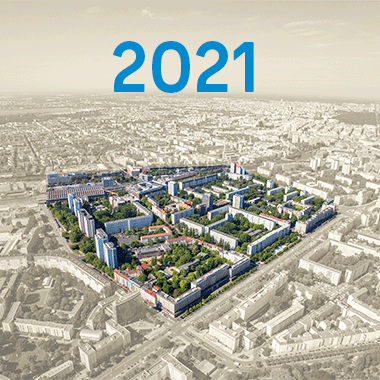
Vorschaubild
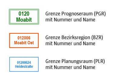
Legende
Provided by

Views
558f4517-a421-3485-973d-50d81a019d57
Access to the portal
Read here the full details and access to the data.
Associated resources
Not available