 INSPIRE-1
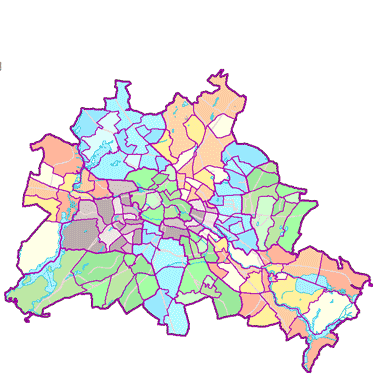
Lebensweltlich orientierte Räume (LOR) (01.01.2021)
Dargestellt werden die Lebensweltlich orientierten Räume in den folgenden drei Ebenen: Progroseraum (58) - Bezirksregion (143) - Planungsraum (542).
Die Prognoseräume sind die Ebene für die teilräumliche Bevölkerungsprognose. Die Bezirksregionen sind die Ebene, auf die sich die Verwaltungsorganisationen der Bezirke ausrichten. Die Planungsräume sind die unterste Ebene für vielfältige Monitorings und Analysen.
|
|
Citation proposal
(2020) . Lebensweltlich orientierte Räume (LOR) (01.01.2021). http://gdk-inspire-1.ffm.gdi-de.org/geonetwork/srv/api/records/5e05b70b-50d6-4164-b0fd-9cdef4e43559 |
- Identification
- Distribution
- Quality
- Spatial rep.
- Ref. system
- Content
- Portrayal
- Metadata
- Md. constraints
- Md. maintenance
- Schema info
Identification
Data identification
Citation
- Date ( Creation )
- 2020-10-30
- Date ( Publication )
- 2020-12-01
- Date ( Revision )
- 2023-01-01
Point of contact
Point of contact
Point of contact
Point of contact
Point of contact
- Maintenance and update frequency
- As needed
- Keywords ( Theme )
-
- inspireidentifiziert
- open data
- opendata
- Karten
- Sachdaten
- Geodaten
- Berlin
- Statistik
- Verwaltung
- Statistical units
- Administrative units
- RBS
- Planungsraum
- PLR
- Prognoseraum
- PGR
- Bezirksregion
- Planungsgrundlagen
- BZR
- LOR
- GEMET - INSPIRE themes, version 1.0 ( Theme )
-
- Statistische Einheiten
- Räumlicher Anwendungsbereich ( Theme )
Legal constraints
- Access constraints
- Other restrictions
Legal constraints
- Use constraints
- Other restrictions
- Other constraints
- Der Datenbestand wird unter der Lizenz CC-BY-3.0-Namensnennung veröffentlicht (vgl. https://creativecommons.org/licenses/by/3.0/de/ ). Als Urheber ist dabei zu nennen: Amt für Statistik Berlin-Brandenburg
- Other constraints
- {"id":"cc-by-de/3.0","name":"Creative Commons - Namensnennung 3.0 Deutschland","url":"https://creativecommons.org/licenses/by/3.0/de/","quelle":"Amt für Statistik Berlin-Brandenburg"}
- Spatial representation type
- Vector
- Denominator
- 5000
- Metadata language
- German
- Character set
- UTF8
- Topic category
-
- Boundaries
Extent
))
Geographic description
- Extent type code
- true
- Geographic identifier
- 110000000000
Distribution
Distribution
- Distribution format
-
-
Text/HTML
(4.01 )
- Specification
- Keine Angabe
-
Text/HTML
(4.01 )
- OnLine resource
-
Darstellungsdienst - Lebensweltlich orientierte Räume (LOR) (01.01.2021) (WMS)
Darstellungsdienst - Lebensweltlich orientierte Räume (LOR) (01.01.2021) (WMS)
- OnLine resource
-
Downloaddienst - Lebensweltlich orientierte Räume (LOR) (01.01.2021) (WFS)
Downloaddienst - Lebensweltlich orientierte Räume (LOR) (01.01.2021) (WFS)
- OnLine resource
-
Inhaltliche Beschreibung
Inhaltliche Beschreibung
Digital transfer options
- OnLine resource
-
Darstellung der Daten im Geoportal Berlin
Darstellung der Daten im Geoportal Berlin
- OnLine resource
-
Änderungsmitteilung 03, Stand 01/2023
Änderungsmitteilung 03, Stand 01/2023
- OnLine resource
-
Änderungsmitteilung 02, Stand 12/2021
Änderungsmitteilung 02, Stand 12/2021
- OnLine resource
-
Änderungsmitteilung 01, Stand 01/2021
Änderungsmitteilung 01, Stand 01/2021
OnLine resource
- Description
- Änderungsmitteilung 03, Stand 01/2023
- Function
- Information
OnLine resource
- Description
- Änderungsmitteilung 02, Stand 12/2021
- Function
- Information
OnLine resource
- Description
- Änderungsmitteilung 01, Stand 01/2021
- Function
- Information
Quality
Data quality
- Hierarchy level
- Dataset
Conformance result
Citation
- Date ( Publication )
- 2010-12-08
- Explanation
- see referenced specification
- Pass
- false
Lineage
- Statement
- Neudigitalisierung im Prozess der LOR-Modifikation 2019/2020 auf Basis von ALKIS und den Blöcken des AfS, Neudigitalisierung im Rahmen der LOR-Modifikation 2019/2020 auf Basis von ALKIS (Stand 06.07. und 05.10.2020) und den Blöcken des AfS
- Description
- Neudigitalisierung im Prozess der LOR-Modifikation 2019/2020 auf Basis von ALKIS und den Blöcken des AfS
- Description
- Neudigitalisierung im Rahmen der LOR-Modifikation 2019/2020 auf Basis von ALKIS (Stand 06.07. und 05.10.2020) und den Blöcken des AfS
Ref. system
- Reference system identifier
- http://www.opengis.net/def/crs/EPSG/0/25833
Metadata
Metadata
- File identifier
- 5e05b70b-50d6-4164-b0fd-9cdef4e43559 XML
- Metadata language
- German
- Character set
- UTF8
- Hierarchy level
- Dataset
- Date stamp
- 2025-11-19T00:00:00Z
- Metadata standard name
- ISO 19115/19119 - BE
- Metadata standard version
- 1.0.0
Point of contact
Overviews
Provided by
