 INSPIRE-1
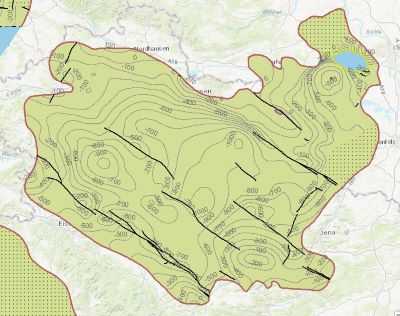
Flat layered salts in Germany
Which salt formations are suitable for storing hydrogen or compressed air? In the InSpEE-DS research project, scientists developed requirements and criteria for the assessment of suitable sites even if their exploration is still at an early stage and there is little knowledge of the salinaries’ structures. Scientists at DEEP.KBB GmbH in Hanover, worked together with their project partners at the Federal Institute for Geosciences and Natural Resources and the Leibniz University Hanover, Institute for Geotechnics Hanover, to develop the planning basis for the site selection and for the construction of storage caverns in flat layered salt and multiple or double saliniferous formations. Such caverns could store renewable energy in the form of hydrogen or compressed air. While the previous project InSpEE was limited to salt formations of great thickness in Northern Germany, salt horizons of different ages have now been examined all over Germany. To estimate the potential, depth contour maps of the top and the base as well as thickness maps of the respective stratigraphic units and reference profiles were developed. Information on compressed air and hydrogen storage potential were given for the identified areas and for the individual federal states. The web service "Information system for flat layered salt" gives access to this data. The scale of display is limited to a minimum of 1:300.000. This geographic information is product of a BMWi-funded research project "InSpEE-DS" running from the year 2015 to 2019. The acronym stands for "Information system salt: planning basis, selection criteria and estimation of the potential for the construction of salt caverns for the storage of renewable energies (hydrogen and compressed air) - double saline and flat salt layers".
|
|
Citation proposal
(2021) . Flat layered salts in Germany. http://gdk-inspire-1.ffm.gdi-de.org/geonetwork/srv/api/records/630430b8-4025-4d6f-9a62-025b53bc8b3d |
INSPIRE
Identification
- File identifier
- 630430b8-4025-4d6f-9a62-025b53bc8b3d XML
- Hierarchy level
- Dataset
Online resource
Resource identifier
- code
- e962ee17-a742-9bca-5a3a-bcb5f46b80e0
- Metadata language
- German
- Spatial representation type
- Vector
Encoding
- Format
- Filegeodatabase
- Version
- n/a
Projection
Classification of data and services
- Topic category
-
- Geoscientific information
Classification of data and services
Coupled resource
Coupled resource
Classification of data and services
Coupled resource
Coupled resource
Keywords
- GEMET - INSPIRE themes, version 1.0 ( Theme )
-
- Geologie
- Geology
- GEMET - Concepts, version 4.1.4 ( Theme )
-
- Energiespeicherung
- Spatial scope
-
- Regional
- High-value dataset categories
-
- Erdbeobachtung und Umwelt
Other keywords
- Keywords ( Theme )
-
- flach lagerndes Salz
- Erneuerbare Energien
- Jura
- Keuper
- Muschelkalk
- Röt
- Zechstein
- Rotliegend
- Salinar
- Energiespeicher
- Kavernen
- opendata
- inspireidentifiziert
- Keywords ( Place )
-
- Deutschland
- Norddeutschland
- Süddeutschland
- Norddeutsches Becken
- Thüringer Becken
- Werra-Fulda- und Fränkisches Becken
Geographic coverage
N
S
E
W
))
Temporal reference
Temporal extent
Temporal extent
- Date ( Publication )
- 2021-06-17
Quality and validity
- Lineage
- Fleig, S., Gast, S., Henneberg, M., Onneken, J., Röhling, S. & Ruales, A. (2020): Informationssystem Salz: Planungsgrundlagen, Auswahlkriterien und Potenzialabschätzung für die Errichtung von Salzkavernen zur Speicherung von Erneuerbaren Energien (Wasserstoff und Druckluft) – Doppelsalinare und flach lagernde Salzschichten, Teilprojekt Salz- und Strukturgeologie. - Sachbericht 03ET6062B: 219 S., 99 Abb. 6. Tab.; Berlin, Hannover.
Conformity
Conformity
Conformity
Conformity
Conformity
Conformity
- Explanation
- siehe dazu die angegebene Durchführungsbestimmung
Restrictions on access and use
- Access constraints
- Allgemeine Geschäftsbedingungen, siehe https://www.bgr.bund.de/AGB - General terms and conditions, see https://www.bgr.bund.de/AGB_en. Die bereitgestellten Informationen sind bei Weiterverwendung wie folgt zu zitieren: Datenquelle: Datenquelle: InSpEE-DS – Flach lagernde Salze in Deutschland, (c) BGR, Hannover, 2021
- Access constraints
- Dieser Datensatz kann gemäß der "Nutzungsbestimmungen für die Bereitstellung von Geodaten des Bundes" (https://sg.geodatenzentrum.de/web_public/gdz/lizenz/geonutzv.pdf) genutzt werden.
- Access constraints
- {"id": "geoNutz/20130319", "name": "Nutzungsbestimmungen für die Bereitstellung von Geodaten des Bundes", "url": "https://sg.geodatenzentrum.de/web_public/gdz/lizenz/geonutzv.pdf", "quelle": "InSpEE-DS – Flach lagernde Salze in Deutschland, (c) BGR, Hannover, 2021"}
Restrictions on access and use
Responsible organization (s)
Contact for the resource
- Organisation name
- Bundesanstalt für Geowissenschaften und Rohstoffe (BGR)
Responsible organization (s)
Contact for the resource
- Organisation name
- Bundesanstalt für Geowissenschaften und Rohstoffe (BGR)
Metadata information
Contact for the metadata
- Organisation name
- Bundesanstalt für Geowissenschaften und Rohstoffe (BGR)
- Date stamp
- 2025-04-23
- Metadata language
- German
- Character set
- UTF8
SDS
Conformance class 1: invocable
Access Point URL
Endpoint URL
Technical specification
Conformance class 2: interoperable
Coordinate reference system
Quality of Service
Access constraints
Limitation
Use constraints
Limitation
Responsible custodian
Contact for the resource
Conformance class 3: harmonized
Overviews
Provided by

Views
630430b8-4025-4d6f-9a62-025b53bc8b3d
Access to the portal
Read here the full details and access to the data.
Associated resources
Not available