 INSPIRE-1
INSPIRE: Information system salt structures: planning basis, selection criteria and estimation of the potential for the construction of salt caverns for the storage of renewable energies (hydrogen and compressed air) (InSpEE)
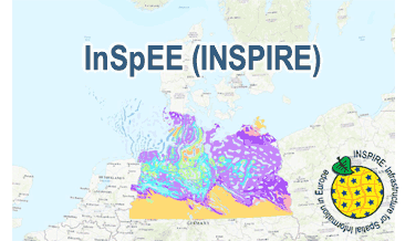
InSpEE (INSPIRE) provides information about the areal distribution of salt structures (salt domes and salt pillows) in Northern Germany. Contours of the salt structures can be displayed at horizontal cross-sections at four different depths up to a maximum depth of 2000 m below NN. The geodata have resulted from a BMWi-funded research project “InSpEE” running from the year 2012 to 2015. The acronym stands for "Information system salt structures: planning basis, selection criteria and estimation of the potential for the construction of salt caverns for the storage of renewable energies (hydrogen and compressed air)”. Additionally four horizontal cross-section maps display the stratigraphical situation at a given depth. In concurrence of maps at different depths areal bedding conditions can be determined, e.g. to generally assess and interpret the spread of different stratigraphic units. Clearly visible are extent and shape of the salt structures within their regional context at the different depths, with extent and boundary of the salt structures having been the main focus of the project. Four horizontal cross-section maps covering the whole onshore area of Northern Germany have been developed at a scale of 1:500.000. The maps cover the depths of -500, -1000, -1500, -2000 m below NN. The four depths are based on typical depth requirements of existing salt caverns in Northern Germany, mainly related to hydrocarbon storage. The shapes of the structures show rudimentary information of their geometry and their change with depths. In addition they form the starting point for rock mechanical calculations necessary for the planning and construction of salt caverns for storage as well as for assessing storage potentials. The maps can be used as a pre-selection tool for subsurface uses. It can also be used to assess coverage and extension of salt structures. Offshore areas were not treated within the project. All horizontal cross-section maps were adjusted with the respective state geological survey organisations. According to the Data Specification on Geology (D2.8.II.4_v3.0) the content of InSpEE (INSPIRE) is stored in 15 INSPIRE-compliant GML files: InSpEE_GeologicUnit_Salt_structure_types.gml contains the salt structure types (salt domes and salt pillows), InSpEE_GeologicUnit_Salt_pillow_remnants.gml comprises the salt pillow remnants, InSpEE_GeologicUnit_Structure_building_salinar.gml represents the structural salinar(s), the four files InSpEE_Structural_outlines_500.gml, InSpEE_Structural_outlines_1000.gml, InSpEE_Structural_outlines_1500.gml and InSpEE_Structural_outlines_2000.gml represent the structural outlines in the corresponding horizontal cross-sections, the four files InSpEE_GeologicUnit_Cross_Section_500, InSpEE_GeologicUnit_Cross_Section_1000, InSpEE_GeologicUnit_Cross_Section_1500 and InSpEE_GeologicUnit_Cross_Section_2000 display the stratigraphical situation in the corresponding horizontal cross-sections and the four files InSpEE_GeologicStructure_500.gml, InSpEE_GeologicStructure_1000.gml, InSpEE_GeologicStructure_1500.gml and InSpEE_GeologicStructure_2000.gml comprise the relevant fault traces in the corresponding horizontal cross-sections. The GML files together with a Readme.txt file are provided in ZIP format (InSpEE-INSPIRE.zip). The Readme.text file (German/English) contains detailed information on the GML files content. Data transformation was proceeded by using the INSPIRE Solution Pack for FME according to the INSPIRE requirements.
|
|
Citation proposal
(2020) . INSPIRE: Information system salt structures: planning basis, selection criteria and estimation of the potential for the construction of salt caverns for the storage of renewable energies (hydrogen and compressed air) (InSpEE). http://gdk-inspire-1.ffm.gdi-de.org/geonetwork/srv/api/records/6b3236df-8fd5-428c-867a-8a6dc06e3166 |
INSPIRE
Identification
- File identifier
- 6b3236df-8fd5-428c-867a-8a6dc06e3166 XML
- Hierarchy level
- dataset Dataset
Online resource
Resource identifier
- Metadata language
- eng English
- Spatial representation type
- Vector
Encoding
- Format
- INSPIRE-GML
- Version
- n/a
Projection
Classification of data and services
- Topic category
-
- Geoscientific information
Classification of data and services
Coupled resource
Coupled resource
Classification of data and services
Coupled resource
Coupled resource
Keywords
- GEMET - INSPIRE themes, version 1.0 ( Theme )
-
- Geologie
- Geology
- Spatial scope
-
- Regional
- High-value dataset categories
-
- Erdbeobachtung und Umwelt
Other keywords
- Keywords ( Theme )
-
- inspireidentifiziert
- Petrographie
- petrography
- Stratigraphie
- stratigraphy
- Tektonik
- tectonics
- opendata
- Salzstock
- Erneuerbare Energiequelle
- Diapir
- Jura
- Keuper
- Zechstein
- Energieträger
- Perm
- Salinar
- Salzintrusion
- Salzkissen
- Salzstruktur
- Energiespeicherung
- Energiespeicher
- Kavernen
- Keywords ( Place )
-
- Norddeutschland
- Northern Germany
Geographic coverage
N
S
E
W
))
Temporal reference
Temporal extent
Temporal extent
- Date ( Publication )
- 2020-02-21
Quality and validity
- Lineage
- The InSpEE (INSPIRE) GML files are based on the InSpEE spatial datasets (Salt structures in Northern Germany and Horizontal cross-section maps of Northern Germany) transformed according to INSPIRE.
- Denominator
- 500000
Conformity
Conformity
Conformity
Conformity
Conformity
Conformity
- Explanation
- See the referenced specification
- Explanation
- See the referenced specification
Restrictions on access and use
- Access constraints
- General Terms and Conditions, s. https://www.bgr.bund.de/agb_en
- Access constraints
- Dieser Datensatz kann gemäß der "Nutzungsbestimmungen für die Bereitstellung von Geodaten des Bundes" (https://sg.geodatenzentrum.de/web_public/gdz/lizenz/geonutzv.pdf) genutzt werden.
- Access constraints
- {"id": "geonutz/20130319", "name": "Nutzungsbestimmungen für die Bereitstellung von Geodaten des Bundes", "url": "https://sg.geodatenzentrum.de/web_public/gdz/lizenz/geonutzv.pdf", "quelle": "Quelle: Bundesanstalt für Geowissenschaften und Rohstoffe (BGR)"}
Restrictions on access and use
Responsible organization (s)
Contact for the resource
- Organisation name
- Bundesanstalt für Geowissenschaften und Rohstoffe (BGR)
Responsible organization (s)
Contact for the resource
- Organisation name
- Bundesanstalt für Geowissenschaften und Rohstoffe (BGR)
Metadata information
Contact for the metadata
- Organisation name
- Bundesanstalt für Geowissenschaften und Rohstoffe (BGR)
- Date stamp
- 2024-04-10
- Metadata language
- English
- Character set
- utf8 UTF8
SDS
Conformance class 1: invocable
Access Point URL
Endpoint URL
Technical specification
Conformance class 2: interoperable
Coordinate reference system
Quality of Service
Access constraints
Limitation
Use constraints
Limitation
Responsible custodian
Contact for the resource
Conformance class 3: harmonized
Overviews
Provided by

Views
6b3236df-8fd5-428c-867a-8a6dc06e3166
Access to the portal
Read here the full details and access to the data.
Associated resources
Not available