 INSPIRE-1
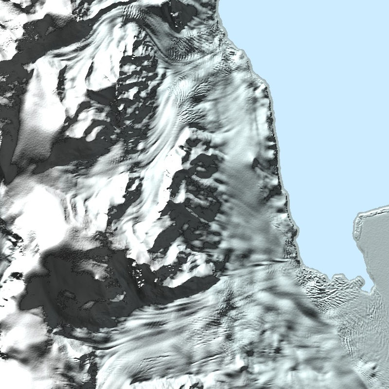
TanDEM-X - PolarDEM - Antarctica, 90m
The TanDEM-X PolarDEM is a project developed by the German Remote Sensing Data Center (DFD) at the German Aerospace Center (DLR) within the activities of the TanDEM-X mission. It is a framework for the provision of derivatives of the global Digital Elevation Model (DEM) of the TanDEM-X mission for Polar Regions. The TanDEM-X PolarDEM 90m of Antarctica is a gap-free and edited version of the TanDEM-X 90m digital elevation model (DEM). The TanDEM-X PolarDEM 90m of Antarctica is provided in Antarctic Polar Stereographic projection (EPSG:3031) with a pixel spacing of 90 meters. The DEM elevation values represent ellipsoidal heights relative to the WGS84 ellipsoid. The majority of the data were acquired between April 2013 and October 2014. The TanDEM-X PolarDEM 90m of Antarctica is split into four tiles.
For more information concerning the TanDEM-X PolarDEM, the reader is referred to: https://www.dlr.de/eoc/en/desktopdefault.aspx/tabid-11882/20871_read-66374/
|
|
Citation proposal
Birgit Wessel (German Aerospace Center (DLR)) - Martin Huber (German Aerospace Center (DLR)). TanDEM-X - PolarDEM - Antarctica, 90m. http://gdk-inspire-1.ffm.gdi-de.org/geonetwork/srv/api/records/74539266-4a28-4148-b252-a9b3e4c8720b |
Simple
- Date ( Creation )
- 2020-07-21T12:13:30
- Presentation form
- Digital map
- Other citation details
- DOI: 10.15489/9jhr18jepi65
- Purpose
- The main objective of the TanDEM-X PolarDEM project is to provide derivatives of the global Digital Elevation Model (DEM) of the TanDEM-X mission for Polar Regions.
- Status
- Completed
Point of contact
Distributor
- Maintenance and update frequency
- As needed
- Keywords
-
- TanDEM-X
- Digital Elevation Model
- TDX-1
- TSX-1
- SAR
- X-Band
- PolarDEM
- Antarctica
- inspireidentifiziert
- GEMET - INSPIRE themes, version 1.0 ( Theme )
-
- Höhe
- Spatial scope ( Theme )
- Use limitation
- Nutzungseinschränkungen: Das DLR ist nicht haftbar für Schäden, die sich aus der Nutzung ergeben. / Use Limitations: DLR not liable for damage resulting from use.
- Access constraints
- Other restrictions
- Use constraints
- Other restrictions
- Other constraints
- License: https://geoservice.dlr.de/resources/licenses/polardem90/TanDEM-X-PolarDEM_User_Licence.pdf
- Spatial representation type
- Grid
- Denominator
- 180000
- Metadata language
- German
- Character set
- UTF8
- Topic category
-
- Elevation
))
- Number of dimensions
- 3
- Dimension name
- Column
- Dimension size
- 61109
- Resolution
- 90 m
- Dimension name
- Row
- Dimension size
- 54789
- Resolution
- 90 m
- Dimension name
- Vertical
- Dimension size
- 1
- Resolution
- 1 m
- Cell geometry
- Area
- Transformation parameter availability
- false
- Distribution format
-
- GeoTIFF ()
- OnLine resource
-
HTTP download (PolarDEM Antarctica)
HTTP download (PolarDEM Antarctica)
- OnLine resource
-
EOC Download Service
EOC Download Service (PolarDEM90)
- OnLine resource
-
TanDEM-X DEM access - scientific users
Webpage with links and description for accessing TanDEM-X elevation models for scientific users.
- OnLine resource
-
TanDEM-X DEM access - non-scientific users
Webpage for accessing/ordering TanDEM-X elevation models for non-scientific users.
- OnLine resource
-
TDM90 - EOC Geoservice Data Guide
EOC Geoservice Data Guide
- OnLine resource
-
EOC Geoservice Map Context
EOC Geoservice Map Context (tdm:polardem90:antarctica)
- OnLine resource
-
TDM_POLARDEM90_ANT_DEM
WMS Access: TanDEM-X PolarDEM 90m of Antarctica (DEM)
- OnLine resource
-
TDM_POLARDEM90_ANT_HSC
WMS Access: TanDEM-X PolarDEM 90m Hillshade Combined of Antarctica (HSC)
- OnLine resource
-
TDM_POLARDEM90_ANT_HSM
WMS Access: TanDEM-X PolarDEM 90m Hillshade Multidirectional of Antarctica (HSM)
- Hierarchy level
- Dataset
Domain consistency
- Measure identification
- INSPIRE / Conformity_001
Conformance result
- Date ( Publication )
- 2010-12-08
- Explanation
- See the referenced specification
- Pass
- true
- Statement
-
The PolarDEM is a derivative of the global TanDEM-X product provided by the TanDEM-X mission. The production steps comprised the following steps:
- gaps in the global TanDEM-X DEM are filled using additional TanDEM-X acquisitions where possible
- the editing process comprises a smoothing of noisy areas, the removal of voids and a replacement of frozen and partially open sea-ice areas with geoid undulations. A semi-automatic approach for coastline delineation was developed and applied to identify the water areas and assign homogeneous height values.
- the editing and gap filling was applied to the TanDEM-X DEM products in their original spacing in geographic coordinates. The TanDEM-X PolarDEM is finally transformed into a polar stereographic projection with a homogeneous metric spacing in northing and easting.
For more information concerning the TanDEM-X PolarDEM product, the reader is referred to
https://www.dlr.de/eoc/en/desktopdefault.aspx/tabid-11882/20871_read-66374/
and:
Wessel, B., Huber, M., Wohlfart, C., Bertram, A., Osterkamp, N., Marschalk, U., Gruber, A., Reuß, F., Abdullahi, S., Georg, I., and Roth, A.: TanDEM-X PolarDEM 90 m of Antarctica: Generation and error characterization, The Cryosphere Discuss. [preprint], https://doi.org/10.5194/tc-2021-19, in review, 2021.
- Description
-
TanDEM-X PolarDEM Processing:
Data:
The PolarDEM is based on the global TanDEM-X DEM and additional TanDEM-X acquisitions which are used for gap filling. Geoid undulations from the Earth Gravitational Model 2008 (EGM2008) are used to replace open sea elevations.
Processing:
DEM gap filling is performed with additional TanDEM-X acquisitions utilizing the Mosaicking and Calibration Processor (MCP) of the TanDEM-X mission. Water body detection, flattening, smoothing and interpolation of outliers and voids is performed within the editing process. The resulting DEM is transformed into a stereographic projection with a homogeneous metric spacing in northing and easting.
Quality Assurance:
An interactive quality control of the DEM gap filling as well as the PolarDEM generation is performed. The resulting PolarDEM is e.g. compared to the global TanDEM-X DEM.
gmd:MD_Metadata
- File identifier
- 74539266-4a28-4148-b252-a9b3e4c8720b XML
- Metadata language
- German
- Character set
- UTF8
- Hierarchy level
- Dataset
- Hierarchy level name
- dataset
- Date stamp
- 2024-06-20T14:12:15
- Metadata standard name
- ISO 19115-1:2014/19139
- Metadata standard version
- 1.0
Point of contact
Overviews

Provided by
