 INSPIRE-1
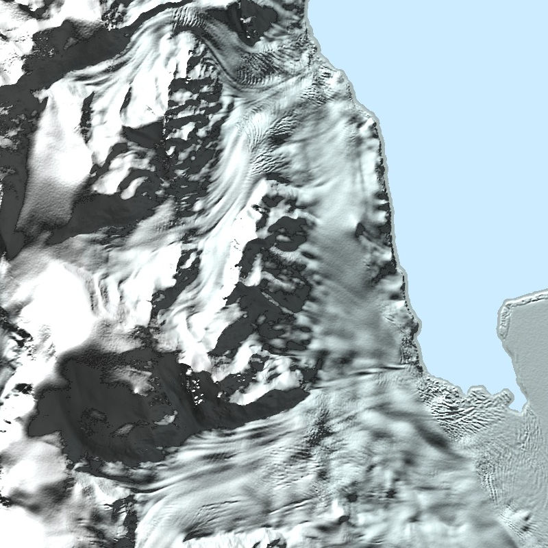
TanDEM-X - PolarDEM - Antarctica, 90m
The TanDEM-X PolarDEM is a project developed by the German Remote Sensing Data Center (DFD) at the German Aerospace Center (DLR) within the activities of the TanDEM-X mission. It is a framework for the provision of derivatives of the global Digital Elevation Model (DEM) of the TanDEM-X mission for Polar Regions. The TanDEM-X PolarDEM 90m of Antarctica is a gap-free and edited version of the TanDEM-X 90m digital elevation model (DEM). The TanDEM-X PolarDEM 90m of Antarctica is provided in Antarctic Polar Stereographic projection (EPSG:3031) with a pixel spacing of 90 meters. The DEM elevation values represent ellipsoidal heights relative to the WGS84 ellipsoid. The majority of the data were acquired between April 2013 and October 2014. The TanDEM-X PolarDEM 90m of Antarctica is split into four tiles.
For more information concerning the TanDEM-X PolarDEM, the reader is referred to: https://www.dlr.de/eoc/en/desktopdefault.aspx/tabid-11882/20871_read-66374/
|
|
Citation proposal
Birgit Wessel (German Aerospace Center (DLR)) - Martin Huber (German Aerospace Center (DLR)). TanDEM-X - PolarDEM - Antarctica, 90m. http://gdk-inspire-1.ffm.gdi-de.org/geonetwork/srv/api/records/74539266-4a28-4148-b252-a9b3e4c8720b |
INSPIRE
Identification
- File identifier
- 74539266-4a28-4148-b252-a9b3e4c8720b XML
- Hierarchy level
- Dataset
Online resource
- Protocol
- WWW:DOWNLOAD-1.0-http--download
- Protocol
- WWW:LINK-1.0-http--link
- Protocol
- WWW:LINK-1.0-http--link
- Protocol
- WWW:LINK-1.0-http--link
- Protocol
- WWW:LINK-1.0-http--link
- Protocol
- WWW:LINK-1.0-http--link
- Protocol
- OGC:WMS
- Protocol
- OGC:WMS
- Protocol
- OGC:WMS
- Protocol
- OGC:WMS-http-get-capabilities
Resource identifier
- Metadata language
- German
- Spatial representation type
- Grid
Encoding
- Format
- GeoTIFF
Projection
Classification of data and services
- Topic category
-
- Elevation
Classification of data and services
Coupled resource
Coupled resource
Classification of data and services
Coupled resource
Coupled resource
Keywords
- GEMET - INSPIRE themes, version 1.0 ( Theme )
-
- Höhe
- Spatial scope ( Theme )
Other keywords
- Keywords
-
- TanDEM-X
- Digital Elevation Model
- TDX-1
- TSX-1
- SAR
- X-Band
- PolarDEM
- Antarctica
- inspireidentifiziert
Geographic coverage
))
Temporal reference
Temporal extent
Temporal extent
- Date ( Creation )
- 2020-07-21T12:13:30
Quality and validity
- Lineage
-
The PolarDEM is a derivative of the global TanDEM-X product provided by the TanDEM-X mission. The production steps comprised the following steps:
- gaps in the global TanDEM-X DEM are filled using additional TanDEM-X acquisitions where possible
- the editing process comprises a smoothing of noisy areas, the removal of voids and a replacement of frozen and partially open sea-ice areas with geoid undulations. A semi-automatic approach for coastline delineation was developed and applied to identify the water areas and assign homogeneous height values.
- the editing and gap filling was applied to the TanDEM-X DEM products in their original spacing in geographic coordinates. The TanDEM-X PolarDEM is finally transformed into a polar stereographic projection with a homogeneous metric spacing in northing and easting.
For more information concerning the TanDEM-X PolarDEM product, the reader is referred to
https://www.dlr.de/eoc/en/desktopdefault.aspx/tabid-11882/20871_read-66374/
and:
Wessel, B., Huber, M., Wohlfart, C., Bertram, A., Osterkamp, N., Marschalk, U., Gruber, A., Reuß, F., Abdullahi, S., Georg, I., and Roth, A.: TanDEM-X PolarDEM 90 m of Antarctica: Generation and error characterization, The Cryosphere Discuss. [preprint], https://doi.org/10.5194/tc-2021-19, in review, 2021.
- Denominator
- 180000
Conformity
Conformity
Conformity
Conformity
Conformity
Conformity
- Explanation
- See the referenced specification
Restrictions on access and use
- Access constraints
- License: https://geoservice.dlr.de/resources/licenses/polardem90/TanDEM-X-PolarDEM_User_Licence.pdf
Restrictions on access and use
Responsible organization (s)
Contact for the resource
- Organisation name
- German Aerospace Center (DLR)
- td-polardem@dlr.de
- Organisation name
- German Aerospace Center (DLR)
- geoservice@dlr.de
- Organisation name
- German Aerospace Center (DLR)
- birgit.wessel@dlr.de
- Organisation name
- German Aerospace Center (DLR)
- martin.huber@dlr.de
Metadata information
Contact for the metadata
- Organisation name
- German Aerospace Center (DLR)
- geoservice@dlr.de
- Date stamp
- 2024-06-20T14:12:15
- Metadata language
- German
- Character set
- UTF8
SDS
Conformance class 1: invocable
Access Point URL
Endpoint URL
Technical specification
Conformance class 2: interoperable
Coordinate reference system
Quality of Service
Access constraints
Limitation
Use constraints
Limitation
Responsible custodian
Contact for the resource
Conformance class 3: harmonized
Overviews

Provided by
