 INSPIRE-1
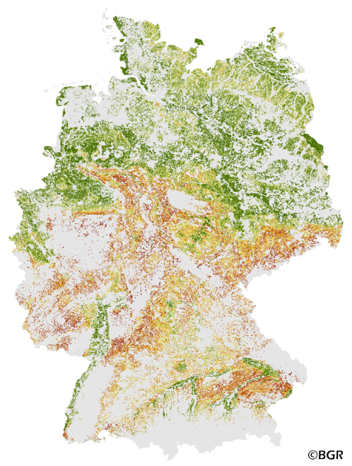
Potential soil erosion risk on arable soils in Germany 1:1,000,000
The Potential Soil Erosion Risk map gives an overview of the exposure of arable soils to soil loss due to surface runoff and splash erosion in Germany. It is based on pedological, relief and climatic factors. The map was created by using the long-term model USLE (Universal Soil Loss Equation). The method is published in the DIN 19708:2005-02 and in the documentation of Ad-hoc-AG Boden (representing the soil experts of the geological services of the German federal states). For the application with soil maps, the method was adapted by the Federal Institute for Geosciences and Natural Resources (BGR).The landuse stratified soil map of Germany at scale 1:1,000,000 was used as pedological input to the model. The relief data was derived from the DEM50 of the BKG. The mean annual precipitation data of the period 1961-1990 (DWD) is used to model the erosivity of rainfall. The land use information is derived from CORINE land cover data set (2006).
|
|
Citation proposal
(2014) . Potential soil erosion risk on arable soils in Germany 1:1,000,000. http://gdk-inspire-1.ffm.gdi-de.org/geonetwork/srv/api/records/876F61A9-36C0-4CDD-9FC1-C243685BC1E8 |
Simple
- Alternate title
- PEGWASSER1000
- Date ( Creation )
- 2013-12-04
- Date ( Publication )
- 2014-01-13
- Edition
- 1.0
- Identifier
- 054df080-7c62-11e3-857a-8851fb422c62
Author
- Status
- completed Completed
Point of contact
Bundesanstalt für Geowissenschaften und Rohstoffe (BGR)
-
Stegger, Ulrich
Stilleweg 2
Hannover
30655
DE
- GEMET - INSPIRE themes, version 1.0 ( Theme )
-
- Boden
- Soil
- GEMET - Concepts, version 2.4 ( Theme )
-
- Ackerbau
- Bodendegradation
- Bodenerosion
- Bodenkarte
- Bodenschutz
- Bodenzustand
- Erosion
- Erosionsschutz
- SGD-Liste ( Theme )
-
- Wassererosion
- Keywords ( Theme )
-
- ABAG
- Bodenerosion durch Wasser
- Erosionsdisposition
- Erosionsgefährdung
- On-Site Schaden
- USLE
- inspireidentifiziert
- opendata
- Keywords ( Place )
-
- Bundesrepublik Deutschland
- Spatial scope
-
- National
- High-value dataset categories
-
- Erdbeobachtung und Umwelt
- Access constraints
- Other restrictions
- Use constraints
- Other restrictions
- Other constraints
- Allgemeine Geschäftsbedingungen, siehe https://www.bgr.bund.de/AGB - General terms and conditions, see https://www.bgr.bund.de/AGB_en. Die bereitgestellten Informationen sind bei Weiterverwendung wie folgt zu zitieren: Datenquelle: PEGWASSER1000 V1.0, (C) BGR, Hannover, 2014
- Other constraints
- Dieser Datensatz kann gemäß der "Nutzungsbestimmungen für die Bereitstellung von Geodaten des Bundes" (https://sg.geodatenzentrum.de/web_public/gdz/lizenz/geonutzv.pdf) genutzt werden.
- Other constraints
- Preis der gedruckten Karte: 11,21 EUR (zzgl. 7% MWSt. und Versandkosten) Weitere Informationen zur Bestellung beim Internationalen Landkartenhaus siehe https://www.bgr.bund.de/produktcenter-bestellhinweis-ILH
- Other constraints
- {"id": "geoNutz/20130319", "name": "Nutzungsbestimmungen für die Bereitstellung von Geodaten des Bundes", "url": "https://sg.geodatenzentrum.de/web_public/gdz/lizenz/geonutzv.pdf", "quelle": "PEGWASSER1000 V1.0, (C) BGR, Hannover, 2014"}
- Spatial representation type
- Grid
- Denominator
- 1000000
- Metadata language
- ger German
- Character set
- utf8 UTF8
- Topic category
-
- Geoscientific information
N
S
E
W
))
- Geographic identifier
- Regionalschlüssel / 000000000000
- Distribution format
-
- PDF (n/a )
- georef. TIFF (n/a )
- JPEG (n/a )
- JPEG (n/a )
- PNG (n/a )
- TIFF (n/a )
- gedruckt (n/a )
- Transfer size
- 95
- OnLine resource
-
PEGWASSER1000 (PDF)
PEGWASSER1000 im Format Adobe Acrobat
- Transfer size
- 12
- OnLine resource
-
PEGWASSER1000 (georef. TIFF)
PEGWASSER1000 im Format georeferenziertes TIFF (Rasterweite 250 m)
- Transfer size
- 56
- OnLine resource
-
PEGWASSER1000 (JPEG)
PEGWASSER1000 im Format JPEG (Auflösung 150 dpi)
- Transfer size
- 192
- OnLine resource
-
PEGWASSER1000 (JPEG)
PEGWASSER1000 im Format JPEG (Auflösung 300 dpi)
- Transfer size
- 34
- OnLine resource
-
PEGWASSER1000 (PNG)
PEGWASSER1000 im Format PNG (Auflösung 150 dpi)
- Transfer size
- 45
- OnLine resource
-
PEGWASSER1000 (TIFF)
PEGWASSER1000 im Format TIFF (Auflösung 300 dpi)
- OnLine resource
-
PEGWASSER1000 (gedruckt)
PEGWASSER1000 im Format gedruckt, gefalzt
- OnLine resource
-
Projektseite
Projektseite
- OnLine resource
-
Karte im BGR-Geoviewer
Karte im BGR-Geoviewer
- Hierarchy level
- Dataset
Conformance result
- Date ( Publication )
- 2010-12-08
- Explanation
- siehe dazu die angegebene Durchführungsbestimmung
- Statement
- Bodendaten aus BÜK1000N V2.31 (BGR), Landnutzung aus Corine Land Cover 2006. Methoden-Wiki im FISBo BGR.
gmd:MD_Metadata
- File identifier
- 876F61A9-36C0-4CDD-9FC1-C243685BC1E8 XML
- Metadata language
- German
- Character set
- utf8 UTF8
- Hierarchy level
- dataset Dataset
- Hierarchy level name
- Boden
- Date stamp
- 2024-04-23
- Metadata standard name
- INSPIRE Metadata Implementing Rules: Technical Guidelines based on EN ISO 19115 and EN ISO 19119
- Metadata standard version
- n/a
Point of contact
Overviews
Provided by

Views
876F61A9-36C0-4CDD-9FC1-C243685BC1E8
Access to the portal
Read here the full details and access to the data.
Associated resources
Not available