 INSPIRE-1
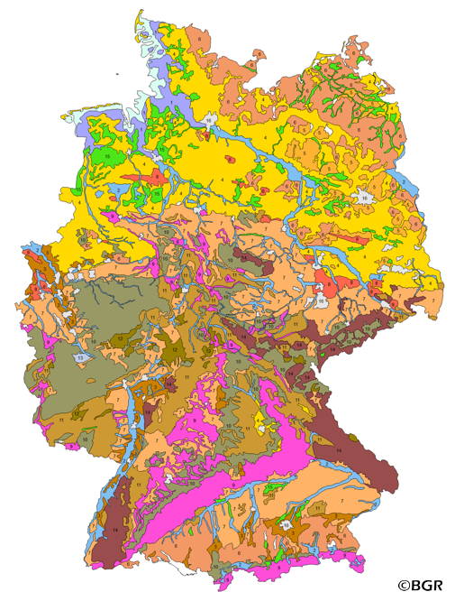
Groups of soil parent material in Germany 1:5,000,000
The presented map at scale 1:5,000,000 shows the distribution of 15 soil parent material groups in Germany with polygons of at least 64 square kilometers. Parent material is the rock, from which soil is formed. It was derived from the landuse use stratified soil map of Germany at scale 1:1,000,000. The version 3.0 of the map is based on the Digital Landscape Model 1:1,000,000 (DLM1000) of the Federal Agency for Cartography and Geodesy.
|
|
Citation proposal
(2007) . Groups of soil parent material in Germany 1:5,000,000. http://gdk-inspire-1.ffm.gdi-de.org/geonetwork/srv/api/records/8BAE7D9F-7FE2-408C-8393-E4444A38568C |
Simple
- Alternate title
- BAG5000
- Date ( Creation )
- 2007-07-02
- Date ( Publication )
- 2007-07-02
- Edition
- Version 3.0 (auf Grundlage der BÜK1000)
- Identifier
- 32623E89-0C8A-4925-B86D-C47B1F7DA333
Author
- Status
- completed Completed
Point of contact
Bundesanstalt für Geowissenschaften und Rohstoffe (BGR)
-
Krug, Dietmar
Stilleweg 2
Hannover
30655
DE
- GEMET - INSPIRE themes, version 1.0 ( Theme )
-
- Boden
- Soil
- GEMET - Concepts, version 2.4 ( Theme )
-
- Bodenart
- Bodenauslaugung
- Bodenbearbeitung
- Bodenbelastung
- Bodenbildung
- Bodenbiologie
- Bodenchemie
- Bodendegradation
- Bodendekontamination
- Bodenerosion
- Bodenfeuchtigkeit
- Bodenfruchtbarkeit
- Bodenfunktion
- Bodengestaltung
- Bodengüte
- Bodenkarte
- Bodenluft
- Bodenmechanik
- Bodenmineralogie
- Bodennutzbarkeit
- Bodennutzung
- SGD-Liste ( Theme )
-
- ackerbauliches Ertragspotential
- Bodeneigenschaften
- Bodengefüge
- Bodengruppe
- Bodenhorizont
- bodenphysikalische Eigenschaften
- Bodenskelett
- Bodenverbreitung
- Durchlässigkeit
- effektive Durchwurzelungstiefe
- Freies Schlagwort ( Theme )
-
- Bodenausgangsgestein
- Bodengesellschaft
- Bodeninformationssystem
- Bodensystematik
- Fachinformationssystem
- inspireidentifiziert
- opendata
- Keywords ( Place )
-
- Bundesrepublik Deutschland
- Spatial scope
-
- National
- High-value dataset categories
-
- Erdbeobachtung und Umwelt
- Access constraints
- Other restrictions
- Use constraints
- Other restrictions
- Other constraints
- Allgemeine Geschäftsbedingungen, siehe https://www.bgr.bund.de/AGB - General terms and conditions, see https://www.bgr.bund.de/AGB_en. Die bereitgestellten Informationen sind bei Weiterverwendung wie folgt zu zitieren: Datenquelle: BAG5000 V3.0, (C) BGR, Hannover, 2007.
- Other constraints
- Dieser Datensatz kann gemäß der "Nutzungsbestimmungen für die Bereitstellung von Geodaten des Bundes" (https://sg.geodatenzentrum.de/web_public/gdz/lizenz/geonutzv.pdf) genutzt werden.
- Other constraints
- {"id": "geoNutz/20130319", "name": "Nutzungsbestimmungen für die Bereitstellung von Geodaten des Bundes", "url": "https://sg.geodatenzentrum.de/web_public/gdz/lizenz/geonutzv.pdf", "quelle": "BAG5000 V3.0, (C) BGR, Hannover, 2007"}
- Spatial representation type
- Vector
- Denominator
- 5000000
- Metadata language
- ger German
- Character set
- utf8 UTF8
- Topic category
-
- Geoscientific information
N
S
E
W
))
- Geographic identifier
- Regionalschlüssel / 000000000000
- Distribution format
-
- PDF (n/a )
- Shapefile (n/a )
- JPEG (n/a )
- PNG (n/a )
- TIFF (n/a )
- Transfer size
- 3
- OnLine resource
-
BAG5000 (PDF)
BAG5000 im Format Adobe Acrobat Datei
- Transfer size
- 3
- OnLine resource
-
BAG5000 (Shapefile)
BAG5000 im Format ESRI Shape
- Transfer size
- 3
- OnLine resource
-
BAG5000 (JPEG)
BAG5000 im Format JPEG (Auflösung 300 dpi)
- Transfer size
- 2
- OnLine resource
-
BAG5000 (PNG)
BAG5000 im Format PNG (Auflösung 150 dpi)
- Transfer size
- 3
- OnLine resource
-
BAG5000 (TIFF)
BAG5000 im Format TIFF (Auflösung 300 dpi)
- OnLine resource
-
BAG5000-Internetseite - BAG5000-Website
BAG5000-Internetseite - BAG5000-Website
- OnLine resource
-
Karte im BGR-Geoviewer
Karte im BGR-Geoviewer
- Hierarchy level
- Dataset
Conformance result
- Date ( Publication )
- 2010-12-08
- Explanation
- siehe dazu die angegebene Durchführungsbestimmung
- Statement
- BÜK1000N Version 2.3.
gmd:MD_Metadata
- File identifier
- 8BAE7D9F-7FE2-408C-8393-E4444A38568C XML
- Metadata language
- German
- Character set
- utf8 UTF8
- Hierarchy level
- dataset Dataset
- Hierarchy level name
- Boden
- Date stamp
- 2024-04-23
- Metadata standard name
- INSPIRE Metadata Implementing Rules: Technical Guidelines based on EN ISO 19115 and EN ISO 19119
- Metadata standard version
- n/a
Point of contact
Overviews
Provided by

Views
8BAE7D9F-7FE2-408C-8393-E4444A38568C
Access to the portal
Read here the full details and access to the data.
Associated resources
Not available