 INSPIRE-1
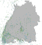
LGRB-BW INSPIRE LED: Tektonische Erdbeben seit 1994 (Natural Risk Zone: Observed Events) - Datensatz
Der Erdbebenkatalog Baden-Württemberg beinhaltet Angaben über Erdbeben in und um Baden-Württemberg. Kartenmäßig dargestellt sind natürliche Erdbeben im Gebiet 47.3°N bis 50.0°N und 7.2°E bis 10.75°E seit 1994. Ab 1996 ist der Katalog vollständig für Erdbeben stärker als etwa Magnitude ML = 2.0 (Richter-Skala). Mit dem Ausbau des Messnetzes und der gestiegenen Empfindlichkeit kann heute von einer Vollständigkeit mindestens ab Magnitude ML=1.5 im bearbeiteten Gebiet ausgegangen werden. Steinbruchsprengungen sind im Katalog nicht enthalten. Weitere Informationen unter:
https://lgrb-bw.de/erdbeben/jahresbulletins
|
|
Citation proposal
. LGRB-BW INSPIRE LED: Tektonische Erdbeben seit 1994 (Natural Risk Zone: Observed Events) - Datensatz. http://gdk-inspire-1.ffm.gdi-de.org/geonetwork/srv/api/records/9543fb30-619c-44eb-bda1-cc5b7be249b8 |
INSPIRE
Identification
- File identifier
- 9543fb30-619c-44eb-bda1-cc5b7be249b8 XML
- Hierarchy level
- Dataset
Online resource
Resource identifier
- Metadata language
- German
- Spatial representation type
- Vector
Encoding
- Format
- ESRI Shapefile
- Version
- n/a (default)
- Specification
- https://www.esri.com/content/dam/esrisites/sitecore-archive/Files/Pdfs/library/whitepapers/pdfs/shapefile.pdf
Projection
Classification of data and services
- Topic category
-
- Geoscientific information
- Environment
Classification of data and services
Coupled resource
Coupled resource
Classification of data and services
Coupled resource
Coupled resource
Keywords
- Liste der Datenkategorien in der GDI-BW für Geodaten
-
- inspireidentifiziert
- GEMET - INSPIRE themes, version 1.0 ( Theme )
- Spatial scope
- GDI-BW-Schlüsselwortliste nach dem mehrsprachigen Umwelt-Thesaurus GEMET
-
- Geologie
- Monitoring
Other keywords
- Keywords
-
- Erdbeben
Geographic coverage
N
S
E
W
))
Temporal reference
Temporal extent
Temporal extent
- Date ( Revision )
- 2022-10-01
Quality and validity
- Lineage
- Erdbebenkatalog von Baden-Württemberg
- Denominator
- 350000
Conformity
Conformity
Conformity
Conformity
Conformity
Conformity
Restrictions on access and use
Restrictions on access and use
Responsible organization (s)
Contact for the resource
- Organisation name
- Regierungspräsidium Freiburg - Abteilung 9 Landesamt für Geologie, Rohstoffe und Bergbau, Ref. 98 Landeserdbebendienst
- abteilung9@rpf.bwl.de
Responsible organization (s)
Contact for the resource
- Organisation name
- Regierungspräsidium Freiburg - Abteilung 9 Landesamt für Geologie, Rohstoffe und Bergbau, Ref. 98 Landeserdbebendienst
- abteilung9@rpf.bwl.de
Metadata information
Contact for the metadata
- Organisation name
- Regierungspräsidium Freiburg - Abteilung 9 Landesamt für Geologie, Rohstoffe und Bergbau, Referat 91 Geowissenschaftliches Landeservicezentrum
- abteilung9@rpf.bwl.de
- Organisation name
- Regierungspräsidium Freiburg - Abteilung 9 Landesamt für Geologie, Rohstoffe und Bergbau, Referat 91 Geowissenschaftliches Landeservicezentrum
- abteilung9@rpf.bwl.de
- Date stamp
- 2023-05-23T09:48:46
- Metadata language
- German
- Character set
- UTF8
SDS
Conformance class 1: invocable
Access Point URL
Endpoint URL
Technical specification
Conformance class 2: interoperable
Coordinate reference system
Quality of Service
Access constraints
Limitation
Use constraints
Limitation
Responsible custodian
Contact for the resource
Conformance class 3: harmonized
Overviews
thumbnail
Provided by

Views
9543fb30-619c-44eb-bda1-cc5b7be249b8
Access to the portal
Read here the full details and access to the data.
Associated resources
Not available