 POC 3.12
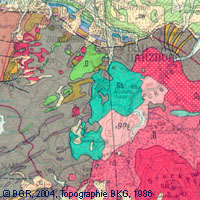
General Geological Map of the Federal Republic of Germany 1:200,000
Das Kartenwerk der Geologischen Übersichtskarte der Bundesrepublik Deutschland 1:200.000 (GÜK200) ist das Produkt einer Gemeinschaftsarbeit zwischen den Staatlichen Geologischen Diensten (SGD), den Geologischen Diensten der Nachbarländer und der Bundesanstalt für Geowissenschaften und Rohstoffe (BGR). Die GÜK200 bildet auf 55 Kartenblättern die Oberflächengeologie von Deutschland und der angrenzenden Gebieten der Nachbarländer ab. Auf den Kartenblättern wird die regionale Verbreitung von mehr als 3800 geologischen Einheiten dargestellt. Die geologischen Einheiten enthalten Informationen zur Stratigraphie (Alter), Genese (Entstehung) und Petrographie (Zusammensetzung) der Gesteine. Jedes gedruckte/gescannte Kartenblatt enthält ein oder mehrere geologische Schnitte, die einen Einblick in den Untergrund vermitteln. Die digitalen Daten des Kartenwerks sind für jedes einzelne Kartenblatt separat abgelegt. D.h. die geologischen Einheiten/Flächen, ihre Grenzen sowie die tektonischen Linienelemente und gegebenenfalls die Eisrandlagen sind pro Kartenblatt als einzelne Layer in einem Shapefile abgespeichert. Die Attribute der geologischen Einheiten enthalten – wie in den gedruckten Kartenblättern – Informationen zur Stratigraphie, Genese und Petrographie der Gesteine.
The map series General Geological Map of the Federal Republic of Germany 1:200,000 (GÜK200) is the result of cooperation between the State Geological Surveys of the Federal Republic of Germany (SGD), the Geological Surveys of neighbouring countries and the Federal Institute for Geosciences and Natural Resources (BGR). The GÜK200 displays the surface geology of Germany and adjacent areas of neighbouring countries on 55 map sheets. The map sheets show the regional dissemination of more than 3800 geological units. The geological units contain information on stratigraphy (age), genesis and petrography (composition) of the rocks. Each printed/scanned map sheet contains one or several geological cross-sections which give an insight into the subsurface. The digital data of the map series are stored separately for each map sheet. According to this geological units/polygons, their boundaries, tectonic linear elements and, if present, ice sheet boundaries are saved as a discrete layer in a shapefile for the single map sheets. The attributes of the geological units contain information – like in the printed map sheets – on stratigraphy, genesis and petrography of the rocks.
INSPIRE
Identification
- File identifier
- ABA9633F-E0BA-438D-918C-6B3BEB4D641C XML
- Hierarchy level
- Series
Online resource
Resource identifier
- code
-
57208E6C-27D2-41CB-8F7A-8B9091737855
- Metadata language
- Deutsch
- Spatial representation type
- Grid
- Spatial representation type
- Vector
Encoding
- Format
-
PDF
- Version
-
n/a
- Format
-
Shapefile
- Version
-
n/a
- Format
-
JPEG
- Version
-
n/a
- Format
-
TIFF
- Version
-
n/a
- Format
-
GEOTIFF
- Version
-
n/a
Projection
- code
- EPSG:31467
Classification of data and services
- Topic category
-
- Geoscientific information
Classification of data and services
Coupled resource
Coupled resource
Classification of data and services
Coupled resource
Coupled resource
Keywords
-
GEMET - INSPIRE themes, version 1.0
-
-
Geologie
-
-
Spatial scope
-
-
National
-
Other keywords
- Theme
-
-
Allgemeine Geologie
-
inspireidentifiziert
-
EGDI
-
opendata
-
- Place
-
-
Deutschland
-
Geographic coverage
))
Temporal reference
Temporal extent
Temporal extent
- Date (Publication)
- 2007-03-09
Quality and validity
- Lineage
-
-
- Denominator
- 200000
Conformity
Conformity
Conformity
Conformity
Conformity
Conformity
- Explanation
-
siehe dazu die angegebene Durchführungsbestimmung
Restrictions on access and use
- Access constraints
- Es gelten keine Zugriffsbeschränkungen
- Access constraints
-
Allgemeine Geschäftsbedingungen, s. https://www.bgr.bund.de/agb - General Terms and Conditions, s. https://www.bgr.bund.de/agb_en
- Access constraints
-
Dieser Datensatz kann gemäß der "Nutzungsbestimmungen für die Bereitstellung von Geodaten des Bundes" ( https://sg.geodatenzentrum.de/web_public/gdz/lizenz/geonutzv.pdf) genutzt werden.
- Access constraints
-
{"id": "geoNutz/20130319", "name": "Nutzungsbestimmungen für die Bereitstellung von Geodaten des Bundes", "url": " https://sg.geodatenzentrum.de/web_public/gdz/lizenz/geonutzv.pdf", "quelle": "Bundesanstalt für Geowissenschaften und Rohstoffe (BGR)"}
Responsible organization (s)
Contact for the resource
- Organisation name
-
Bundesanstalt für Geowissenschaften und Rohstoffe
-
geologie.daten@bgr.de geologie.daten@bgr.de
Responsible organization (s)
Contact for the resource
- Organisation name
-
Bundesanstalt für Geowissenschaften und Rohstoffe
-
geologie.daten@bgr.de geologie.daten@bgr.de
Metadata information
Contact for the metadata
- Organisation name
-
Bundesanstalt für Geowissenschaften und Rohstoffe (BGR)
-
geodatenmanagement@bgr.de geodatenmanagement@bgr.de
- Date stamp
- 2023-08-18
- Metadata language
- Deutsch
- Character set
- UTF8
SDS
Conformance class 1: invocable
Access Point URL
Endpoint URL
Technical specification
Conformance class 2: interoperable
Access constraints
Limitation
Use constraints
Limitation
Responsible custodian
Contact for the resource
Overviews
Spatial extent
Provided by
