 INSPIRE-1
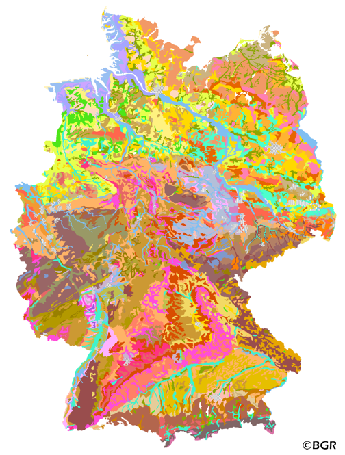
Soil Map of the Federal Republic of Germany 1:2,000,000
The BUEK2000 Version 1.0 was compiled from the BÜK1000 map by a process of generalization. The number of soil mapping units in the legend was reduced from 72 to 60 by aggregation of those units showing similar dominamt soils into single units. The map combined with selected soil profile pictures/graphics and information about soil history, soil classification and soil mapping in Germany is one fundamental part of the Hydrolocical Atlas of Germany (HAD). The Version 2.0, based on the BUEK2000N, Version 2.3, was cartographically adapted to a new base map.
|
|
Citation proposal
(2014) . Soil Map of the Federal Republic of Germany 1:2,000,000. http://gdk-inspire-1.ffm.gdi-de.org/geonetwork/srv/api/records/AF434BE2-57D6-47AB-8D5B-F47927184990 |
- Identification
- Distribution
- Quality
- Spatial rep.
- Ref. system
- Content
- Portrayal
- Metadata
- Md. constraints
- Md. maintenance
- Schema info
Identification
Data identification
Citation
- Alternate title
- BÜK2000
- Date ( Creation )
- 1998-09-01
- Date ( Publication )
- 2014-04-28
- Edition
- Version 2.0
- Identifier
- BD178081-268F-41A9-85A5-C89B96B96618
Author
- Status
- completed Completed
Point of contact
Bundesanstalt für Geowissenschaften und Rohstoffe (BGR)
-
Krug, Dietmar
Stilleweg 2
Hannover
30655
DE
- GEMET - INSPIRE themes, version 1.0 ( Theme )
-
- Boden
- Soil
- GEMET - Concepts, version 2.4 ( Theme )
-
- Bodenart
- Bodenauslaugung
- Bodenbearbeitung
- Bodenbelastung
- Bodenbildung
- Bodenbiologie
- Bodenchemie
- Bodendegradation
- Bodendekontamination
- Bodenerosion
- Bodenfeuchtigkeit
- Bodenfruchtbarkeit
- Bodenfunktion
- Bodengestaltung
- Bodengüte
- Bodenkarte
- Bodenluft
- Bodenmechanik
- Bodenmineralogie
- Bodennutzbarkeit
- Bodennutzung
- SGD-Liste ( Theme )
-
- ackerbauliches Ertragspotential
- Bodeneigenschaften
- Bodengefüge
- Bodengruppe
- Bodenhorizont
- bodenphysikalische Eigenschaften
- Bodenskelett
- Bodenverbreitung
- Durchlässigkeit
- effektive Durchwurzelungstiefe
- Freies Schlagwort ( Theme )
-
- Bodenausgangsgestein
- Bodengesellschaft
- Bodeninformationssystem
- Bodensystematik
- Fachinformationssystem
- inspireidentifiziert
- opendata
- Keywords ( Place )
-
- Bundesrepublik Deutschland
- Spatial scope
-
- National
- High-value dataset categories
-
- Erdbeobachtung und Umwelt
Legal constraints
- Access constraints
- Other restrictions
Legal constraints
- Use constraints
- Other restrictions
- Other constraints
- Allgemeine Geschäftsbedingungen, siehe https://www.bgr.bund.de/AGB - General terms and conditions, see https://www.bgr.bund.de/AGB_en. Die bereitgestellten Informationen sind bei Weiterverwendung wie folgt zu zitieren: Datenquelle: BÜK2000 V2.0, (C) BGR, Hannover, 2014.
- Other constraints
- Dieser Datensatz kann gemäß der "Nutzungsbestimmungen für die Bereitstellung von Geodaten des Bundes" (https://sg.geodatenzentrum.de/web_public/gdz/lizenz/geonutzv.pdf) genutzt werden.
- Other constraints
- {"id": "geoNutz/20130319", "name": "Nutzungsbestimmungen für die Bereitstellung von Geodaten des Bundes", "url": "https://sg.geodatenzentrum.de/web_public/gdz/lizenz/geonutzv.pdf", "quelle": "BÜK2000 V2.0, (C) BGR, Hannover, 2014"}
- Spatial representation type
- Vector
- Denominator
- 2000000
- Metadata language
- ger German
- Character set
- utf8 UTF8
- Topic category
-
- Geoscientific information
N
S
E
W
))
- Geographic identifier
- Regionalschlüssel / 000000000000
Distribution
Distribution
- Distribution format
-
- PDF (n/a )
- Shapefile (n/a )
- JPEG (n/a )
- PNG (n/a )
- TIFF (n/a )
Digital transfer options
- Transfer size
- 5
- OnLine resource
-
BÜK2000 (PDF)
BÜK2000 im Format Adobe Acrobat Datei (Auflösung 600 dpi)
Digital transfer options
- Transfer size
- 6
- OnLine resource
-
BÜK2000 (Shapefile)
BÜK2000 im Format ESRI Shape
Digital transfer options
- Transfer size
- 11
- OnLine resource
-
BÜK2000 (JPEG)
BÜK2000 im Format JPEG (Auflösung 300 dpi)
Digital transfer options
- Transfer size
- 8
- OnLine resource
-
BÜK2000 (PNG)
BÜK2000 im Format PNG (Auflösung 150 dpi)
Digital transfer options
- Transfer size
- 10
- OnLine resource
-
BÜK2000 (TIFF)
BÜK2000 im Format TIFF (Auflösung 300 dpi)
- OnLine resource
-
BÜK2000-Internetseite - BUEK2000 Website
BÜK2000-Internetseite - BUEK2000 Website
- OnLine resource
-
Karte im BGR-Geoviewer
Karte im BGR-Geoviewer
Quality
Data quality
Scope
- Hierarchy level
- Dataset
Conformance result
Citation
- Date ( Publication )
- 2010-12-08
- Explanation
- siehe dazu die angegebene Durchführungsbestimmung
- Statement
- BÜK1000 Version 1.0, BÜK2000N Version 2.3. Der Legendentext der Legendeneinheit 56 ist aufgrund der eingeschränkten Datenfeldlänge von 255 Zeichen nicht ganz vollständig. Bei Bedarf kann dieser einer separaten Tabelle entnommen werden. -
Metadata
Metadata
- File identifier
- AF434BE2-57D6-47AB-8D5B-F47927184990 XML
- Metadata language
- German
- Character set
- utf8 UTF8
- Hierarchy level
- dataset Dataset
- Hierarchy level name
- Boden
- Date stamp
- 2024-04-23
- Metadata standard name
- INSPIRE Metadata Implementing Rules: Technical Guidelines based on EN ISO 19115 and EN ISO 19119
- Metadata standard version
- n/a
Point of contact
Overviews
Provided by

Views
AF434BE2-57D6-47AB-8D5B-F47927184990
Access to the portal
Read here the full details and access to the data.
Associated resources
Not available