 INSPIRE-1
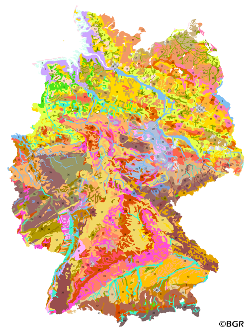
Soil Map of the Federal Republic of Germany 1:3,000,000
The BUEK3000 is prepared by the Federal Institute for Geosciences and Natural Resources (BGR) for the National Atlas of Germany. Based on the generalized and aggregated soil map 1:2,000,000, it shows 43 mapping units with information about soil texture, parent material, dominant and associated soils.
|
|
Citation proposal
(2005) . Soil Map of the Federal Republic of Germany 1:3,000,000. http://gdk-inspire-1.ffm.gdi-de.org/geonetwork/srv/api/records/BFAD24E1-5760-476A-AD11-9B384FD09FEB |
Simple
- Alternate title
- BÜK3000
- Date ( Publication )
- 2005-12-01
- Edition
- Version 2.1
- Identifier
- B4ECE467-8B93-413B-8338-6EA483D4F067
Author
- Status
- completed Completed
Point of contact
Bundesanstalt für Geowissenschaften und Rohstoffe (BGR)
-
Krug, Dietmar
Stilleweg 2
Hannover
30655
DE
- GEMET - INSPIRE themes, version 1.0 ( Theme )
-
- Boden
- Soil
- GEMET - Concepts, version 2.4 ( Theme )
-
- Bodenart
- Bodenauslaugung
- Bodenbearbeitung
- Bodenbelastung
- Bodenbildung
- Bodenbiologie
- Bodenchemie
- Bodendegradation
- Bodendekontamination
- Bodenerosion
- Bodenfeuchtigkeit
- Bodenfruchtbarkeit
- Bodenfunktion
- Bodengestaltung
- Bodengüte
- Bodenkarte
- Bodenluft
- Bodenmechanik
- Bodenmineralogie
- Bodennutzbarkeit
- Bodennutzung
- SGD-Liste ( Theme )
-
- ackerbauliches Ertragspotential
- Bodeneigenschaften
- Bodengefüge
- Bodengruppe
- Bodenhorizont
- bodenphysikalische Eigenschaften
- Bodenskelett
- Bodenverbreitung
- Durchlässigkeit
- effektive Durchwurzelungstiefe
- Freies Schlagwort ( Theme )
-
- Bodenausgangsgestein
- Bodenform
- Bodengesellschaft
- Bodeninformationssystem
- Bodenprofil
- Bodensubstrat
- Bodensystematik
- Bodentyp
- Fachinformationssystem
- inspireidentifiziert
- opendata
- Keywords ( Place )
-
- Bundesrepublik Deutschland
- Spatial scope
-
- National
- High-value dataset categories
-
- Erdbeobachtung und Umwelt
- Access constraints
- Other restrictions
- Use constraints
- Other restrictions
- Other constraints
- Allgemeine Geschäftsbedingungen, siehe https://www.bgr.bund.de/AGB - General terms and conditions, see https://www.bgr.bund.de/AGB_en. Die bereitgestellten Informationen sind bei Weiterverwendung wie folgt zu zitieren: Datenquelle: BÜK3000 V2.1, (C) BGR, Hannover, 2014.
- Other constraints
- Dieser Datensatz kann gemäß der "Nutzungsbestimmungen für die Bereitstellung von Geodaten des Bundes" (https://sg.geodatenzentrum.de/web_public/gdz/lizenz/geonutzv.pdf) genutzt werden.
- Other constraints
- {"id": "geoNutz/20130319", "name": "Nutzungsbestimmungen für die Bereitstellung von Geodaten des Bundes", "url": "https://sg.geodatenzentrum.de/web_public/gdz/lizenz/geonutzv.pdf", "quelle": "BÜK3000 V2.1, (C) BGR, Hannover, 2014"}
- Spatial representation type
- Vector
- Denominator
- 3000000
- Metadata language
- ger German
- Character set
- utf8 UTF8
- Topic category
-
- Geoscientific information
N
S
E
W
))
- Geographic identifier
- Regionalschlüssel / 000000000000
- Distribution format
-
- PDF (n/a )
- Shapefile (n/a )
- JPEG (n/a )
- PNG (n/a )
- TIFF (n/a )
- Transfer size
- 8
- OnLine resource
-
BÜK3000 (PDF)
BÜK3000 im Format Adobe Acrobat Datei
- Transfer size
- 5
- OnLine resource
-
BÜK3000 (Shapefile)
BÜK3000 im Format ESRI Shape
- Transfer size
- 7
- OnLine resource
-
BÜK3000 (JPEG)
BÜK3000 im Format JPEG (Auflösung 300 dpi)
- Transfer size
- 5
- OnLine resource
-
BÜK3000 (PNG)
BÜK3000 im Format PNG (Auflösung 150 dpi)
- Transfer size
- 6
- OnLine resource
-
BÜK3000 (TIFF)
BÜK3000 im Format TIFF (Auflösung 300 dpi)
- OnLine resource
-
BÜK3000-Internetseite - BUEK3000 Website
BÜK3000-Internetseite - BUEK3000 Website
- OnLine resource
-
Karte im BGR-Geoviewer
Karte im BGR-Geoviewer
- Hierarchy level
- Dataset
Conformance result
- Date ( Publication )
- 2010-12-08
- Explanation
- siehe dazu die angegebene Durchführungsbestimmung
- Statement
- BÜK2000N Version 2.3. Räumliche Anpassung an Kartengrundlage 1:3.000.000 (für BODENATLAS).
gmd:MD_Metadata
- File identifier
- BFAD24E1-5760-476A-AD11-9B384FD09FEB XML
- Metadata language
- German
- Character set
- utf8 UTF8
- Hierarchy level
- dataset Dataset
- Hierarchy level name
- Boden
- Date stamp
- 2024-04-23
- Metadata standard name
- INSPIRE Metadata Implementing Rules: Technical Guidelines based on EN ISO 19115 and EN ISO 19119
- Metadata standard version
- n/a
Point of contact
Overviews
Provided by

Views
BFAD24E1-5760-476A-AD11-9B384FD09FEB
Access to the portal
Read here the full details and access to the data.
Associated resources
Not available