 POC 3.12
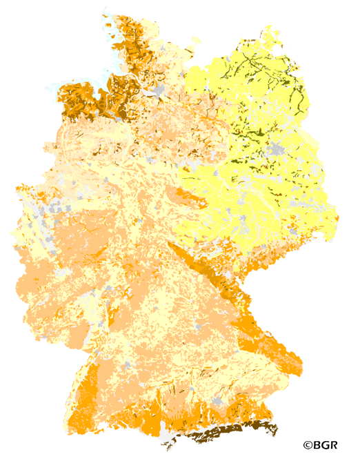
Organic Matter Content of Top-Soils in Germany 1:1,000,000 (WMS)
Web Map Service (WMS) zur Karte der Gehalte an organischer Substanz in Oberböden Deutschlands. Die Karte der Gehalte an organischer Substanz in Oberböden Deutschlands 1:1.000.000 visualisiert die Ergebnisse der deutschlandweiten Zusammenstellung von typischen Gehalten an organischer Substanz der Oberböden differenziert nach 15 Bodenausgangsgesteinsgruppen, der Landnutzung und vier Klimaregionen. Die Auswertung basiert auf mehr als 9000 Bodenprofilen, zu denen qualitätsgesicherte Daten zur organischen Substanz aus einem zwanzigjährigen Zeitraum vorlagen. Das methodische Vorgehen ist in dem Bericht 'Gehalte an organischer Substanz in Oberböden Deutschlands', BGR Archiv, Nr. 0127036 dokumentiert. Die in der Karte dargestellten Klassen entsprechen der Klasseneinteilung in der Bodenkundlichen Kartieranleitung (KA5), wobei die Klassen h2–h5 der KA5 jeweils in der Klassenmitte geteilt wurden. Damit gibt die Karte insbesondere in den Klassen geringer Gehalte ein differenzierteres Bild wider.
Web Map Service (WMS) of the map Organic Matter Content of Top-Soils in Germany. The map Organic Matter Content of Top-Soils in Germany 1:1,000,000 highlights the results of a Germany-wide compilation of typical soil organic matter contents in top-soils differentiated according to 15 groups of soil parent material, four climatic areas and the main land use. The evaluation is based on more than 9000 soil data profiles with information about Soil Organic Matter (SOM) from a period of about 20 years. The report 'The Organic Matter Content of Top-Soils in Germany', BGR Archiv, No. 0127036 (in German) documents the methodology. The classes of the map legend are based on the classes given in the German Soil Mapping Guideline, 5th Edition (KA5). The version 2.0 of the map is based on the Digital Topographic Map 1:1,000,000 (DTK1000-V) of the Federal Agency for Cartography and Geodesy, which was altered in parts by BGR.
INSPIRE
Identification
- File identifier
- F72CF0A3-5373-4A38-B6A2-D378D184540D XML
- Hierarchy level
- Service
Online resource
Resource identifier
Encoding
- Format
-
png
- Version
-
n/a
- Format
-
jpeg
- Version
-
n/a
- Format
-
gif
- Version
-
n/a
Projection
- code
- EPSG:3035
Classification of data and services
- Service Type
- view
- Coupling Type
- Tight
Coupled resource
Coupled resource
Classification of data and services
- Service Type
- view
- Coupling Type
- Tight
Coupled resource
Coupled resource
Keywords
-
GEMET - INSPIRE themes, version 1.0
-
-
Boden
-
soil
-
-
GEMET - Concepts, version 2.4
-
-
Bodenkarte
-
Bodenkunde
-
Bodenschutz
-
Forst
-
Grünland
-
Humus
-
Karte
-
organische Substanz
-
organischer Kohlenstoff
-
Umweltschutz
-
-
Freies Schlagwort
-
-
Acker
-
Atmosphäre
-
Bodenausgangsgesteine
-
Bodeneigenschaft
-
Bodenflächendaten
-
Bodeninformationssystem
-
Fachinformationssystem
-
Geografisches Informationssystem
-
Humusgehalt
-
Humusklassen
-
infoMapAccessService
-
inspireidentifiziert
-
Klima
-
Landnutzung
-
Landwirtschaft
-
Umwelt
-
WMS
-
opendata
-
-
Spatial scope
-
-
National
-
Other keywords
- Place
-
-
Bundesrepublik Deutschland
-
Geographic coverage
))
Temporal reference
Temporal extent
Temporal extent
- Date (Creation)
- 2007-01-01
- Date (Publication)
- 2007-01-01
Quality and validity
- Lineage
-
BÜK 1000 N, Version 2.3; Labor- und Profildatenbank FISBo BGR; zusätzliche Datenbereitstellung durch SGD (Ad-hoc-AG Boden).
Conformity
Conformity
Conformity
Conformity
Conformity
Conformity
- Explanation
-
siehe dazu die angegebene Durchführungsbestimmung
Restrictions on access and use
- Access constraints
- Es gelten keine Zugriffsbeschränkungen
- Access constraints
-
Allgemeine Geschäftsbedingungen, siehe https://www.bgr.bund.de/AGB - General terms and conditions, see https://www.bgr.bund.de/AGB_en. Die bereitgestellten Informationen sind bei Weiterverwendung wie folgt zu zitieren: Datenquelle: HUMUS1000OB V2.0, (C) BGR, Hannover, 2007.
- Access constraints
-
Dieser Datensatz kann gemäß der "Nutzungsbestimmungen für die Bereitstellung von Geodaten des Bundes" ( https://sg.geodatenzentrum.de/web_public/gdz/lizenz/geonutzv.pdf) genutzt werden.
- Access constraints
-
Dieser Datensatz kann gemäß der "Nutzungsbestimmungen für die Bereitstellung von Geodaten des Bundes" ( https://sg.geodatenzentrum.de/web_public/gdz/lizenz/geonutzv.pdf) genutzt werden.
Responsible organization (s)
Contact for the resource
- Organisation name
-
Bundesanstalt für Geowissenschaften und Rohstoffe
-
fis.bo@bgr.de fis.bo@bgr.de
Responsible organization (s)
Contact for the resource
- Organisation name
-
Bundesanstalt für Geowissenschaften und Rohstoffe
-
fis.bo@bgr.de fis.bo@bgr.de
Metadata information
Contact for the metadata
- Organisation name
-
Bundesanstalt für Geowissenschaften und Rohstoffe (BGR)
-
geodatenmanagement@bgr.de geodatenmanagement@bgr.de
- Date stamp
- 2020-07-22
- Metadata language
- Deutsch
SDS
Conformance class 1: invocable
Access Point URL
Endpoint URL
Technical specification
- Date
- Explanation
-
siehe dazu die angegebene Durchführungsbestimmung
Conformance class 2: interoperable
Access constraints
- Access constraints
- Other restrictions
- Other constraints
- Es gelten keine Zugriffsbeschränkungen
Limitation
Use constraints
Limitation
- string
-
Allgemeine Geschäftsbedingungen, siehe https://www.bgr.bund.de/AGB - General terms and conditions, see https://www.bgr.bund.de/AGB_en. Die bereitgestellten Informationen sind bei Weiterverwendung wie folgt zu zitieren: Datenquelle: HUMUS1000OB V2.0, (C) BGR, Hannover, 2007.
- string
-
Dieser Datensatz kann gemäß der "Nutzungsbestimmungen für die Bereitstellung von Geodaten des Bundes" ( https://sg.geodatenzentrum.de/web_public/gdz/lizenz/geonutzv.pdf) genutzt werden.
- string
-
Dieser Datensatz kann gemäß der "Nutzungsbestimmungen für die Bereitstellung von Geodaten des Bundes" ( https://sg.geodatenzentrum.de/web_public/gdz/lizenz/geonutzv.pdf) genutzt werden.
Responsible custodian
Contact for the resource
Conformance class 3: harmonized
Contains Operations
- Operation Name
-
GetCapabilities
- Distributed Computing Platforms
- Web services
- Connect Point
- https://services.bgr.de/wms/boden/humus1000ob/?
Contains Operations
- Operation Name
-
GetMap
- Distributed Computing Platforms
- Web services
- Connect Point
- https://services.bgr.de/wms/boden/humus1000ob/?
Overviews
Spatial extent
Provided by
