 INSPIRE-1
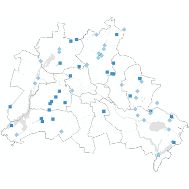
Messstellen der Landeshydrologie - Pegelstandorte
Lage der Messstellen der Landeshydrologie bzw. der Pegelstandorte. An den Messstellen der Landeshydrologie wird der Wasserstand und Durchfluss in den Berliner Fließgewässern und Seen gemessen. Die Messwerte, statistischen Kennwerte sowie weitere Informationen zu den Messstellen des hydrologischen Landesmessnetzes werden im Wasserportal zur Verfügung gestellt (https://wasserportal.berlin.de/start.php).
|
|
Citation proposal
(2024) . Messstellen der Landeshydrologie - Pegelstandorte. http://gdk-inspire-1.ffm.gdi-de.org/geonetwork/srv/api/records/be94cf3d-57a5-3a22-b6d2-45113fb30127 |
INSPIRE
Identification
- File identifier
- be94cf3d-57a5-3a22-b6d2-45113fb30127 XML
- Hierarchy level
- Dataset
Online resource
Resource identifier
- Metadata language
- German
- Spatial representation type
- Vector
Encoding
- Format
- Environmental Monitoring Facilities GML Application Schema
- Version
- GML version 3.2.1
- Specification
- D2.8.III.7 Data Specification on Environmental Monitoring Facilities ? Technical Guidelines
Projection
Classification of data and services
- Topic category
-
- Structure
Classification of data and services
Coupled resource
Coupled resource
Classification of data and services
Coupled resource
Coupled resource
Keywords
- GEMET - INSPIRE themes, version 1.0 ( Theme )
-
- Umweltüberwachung
- Spatial scope
Other keywords
- Keywords ( Theme )
-
- inspireidentifiziert
- Karten
- Berlin
- Geodaten
- Landeshydrologie
- Pegelstandorte
- Wasserstand
- Abfluss
- Fließgewässer
- Seen
- Pegel
- Durchfluss
- Fluss
- See
- Oberflächengewässer
- Gewässer 1. Ordnung
- Gewässer 2. Ordnung
- Messstellen
- Hydrologie
- Wasser
- Wasserportal
- Wasserstandsmessstelle
- Hydrometrie
Geographic coverage
N
S
E
W
))
Temporal reference
Temporal extent
Temporal extent
- Date ( Creation )
- 2024-01-01
- Date ( Publication )
- 2024-01-22
Quality and validity
- Lineage
- Berliner Messnetz
- Denominator
- 50000
Conformity
Conformity
Conformity
Conformity
Conformity
Conformity
Restrictions on access and use
- Access constraints
- Für die Nutzung der Daten ist die Datenlizenz Deutschland - Namensnennung - Version 2.0 anzuwenden. Die Lizenz ist über https://www.govdata.de/dl-de/by-2-0 abrufbar. Der Quellenvermerk gemäß (2) der Lizenz lautet "Geoportal Berlin / [Titel des Datensatzes]".
- Access constraints
- { "id": "dl-by-de/2.0" , "name": "Datenlizenz Deutschland - Namensnennung - Version 2.0", "url": "https://www.govdata.de/dl-de/by-2-0", "quelle": "Geoportal Berlin / [Titel des Datensatzes]" }
Restrictions on access and use
Responsible organization (s)
Contact for the resource
- Organisation name
- Senatsverwaltung für Mobilität, Verkehr, Klimaschutz und Umwelt Berlin
Responsible organization (s)
Contact for the resource
- Organisation name
- Senatsverwaltung für Mobilität, Verkehr, Klimaschutz und Umwelt Berlin
Metadata information
Contact for the metadata
- Organisation name
- Senatsverwaltung für Stadtentwicklung, Bauen und Wohnen Berlin
- Date stamp
- 2024-10-10T11:14:43
- Metadata language
- German
- Character set
- UTF8
SDS
Conformance class 1: invocable
Access Point URL
Endpoint URL
Technical specification
Conformance class 2: interoperable
Coordinate reference system
Quality of Service
Access constraints
Limitation
Use constraints
Limitation
Responsible custodian
Contact for the resource
Conformance class 3: harmonized
Overviews
Provided by

Views
be94cf3d-57a5-3a22-b6d2-45113fb30127
Access to the portal
Read here the full details and access to the data.
Associated resources
Not available