 INSPIRE-1
World Settlement Footprint (WSF) 2019 - Sentinel-1/2 - Global
|
|
Citation proposal
Mattia Marconcini (German Aerospace Center (DLR)). World Settlement Footprint (WSF) 2019 - Sentinel-1/2 - Global. http://gdk-inspire-1.ffm.gdi-de.org/geonetwork/srv/api/records/cbc6cb05-1245-41f9-a866-051119441187 |
Simple
- Date ( Creation )
- 2021-11-01T00:00:00
- Edition
- Presentation form
- Digital map
- Other citation details
- DOI: 10.15489/twg5xsnquw84
- Purpose
- The main objective of the World Settlement Footprint project is to depict the globals settlement extent.
- Status
- Completed
Point of contact
Point of contact
Point of contact
- Maintenance and update frequency
- As needed
- Keywords
-
- opendata
- global
- urbanization
- land
- global settlement extent
- Sentinel-1
- Sentinel-2
- inspireidentifiziert
- GEMET - INSPIRE themes, version 1.0 ( Theme )
-
- Land cover
- Use limitation
- Nutzungseinschränkungen: Das DLR ist nicht haftbar für Schäden, die sich aus der Nutzung ergeben. / Use Limitations: DLR not liable for damage resulting from use.
- Access constraints
- Other restrictions
- Use constraints
- Other restrictions
- Other constraints
- Nutzungsbedingungen: Lizenz, https://creativecommons.org/licenses/by/4.0 / terms of use: https://creativecommons.org/licenses/by/4.0/
- Other constraints
-
{"id": "cc-by/4.0",
"name": "Creative Commons Namensnennung – 4.0 International (CC BY 4.0)",
"url": "http://dcat-ap.de/def/licenses/cc-by/4.0",
"quelle": "Copyright DLR (2021)"}
- Spatial representation type
- Grid
- Denominator
- 20000
- Metadata language
- English
- Character set
- UTF8
- Topic category
-
- Imagery base maps earth cover
))
- Supplemental Information
- Number of dimensions
- 2
- Dimension name
- Column
- Dimension size
- 4007726
- Resolution
- 10 m
- Dimension name
- Row
- Dimension size
- 1536433
- Resolution
- 10 m
- Cell geometry
- Area
- Transformation parameter availability
- false
- Distribution format
-
- GeoTIFF ()
- OnLine resource
-
EOC Geoservice Dataset
EOC Geoservice Dataset
- OnLine resource
-
WSF_2019
World Settlement Footprint 2019
- OnLine resource
-
EOC Geoservice Map Context
EOC Geoservice Map Context
- OnLine resource
-
EOC Download Service
EOC Download Service
- OnLine resource
-
EOC STAC Collection
EOC STAC Collection
- OnLine resource
-
World Settlement Footprint - DLR News
World Settlement Footprint - DLR News
- Hierarchy level
- Dataset
Domain consistency
- Measure identification
- INSPIRE / Conformity_001
Conformance result
- Date ( Publication )
- 2010-12-08
- Explanation
- See the referenced specification
- Pass
- true
- Statement
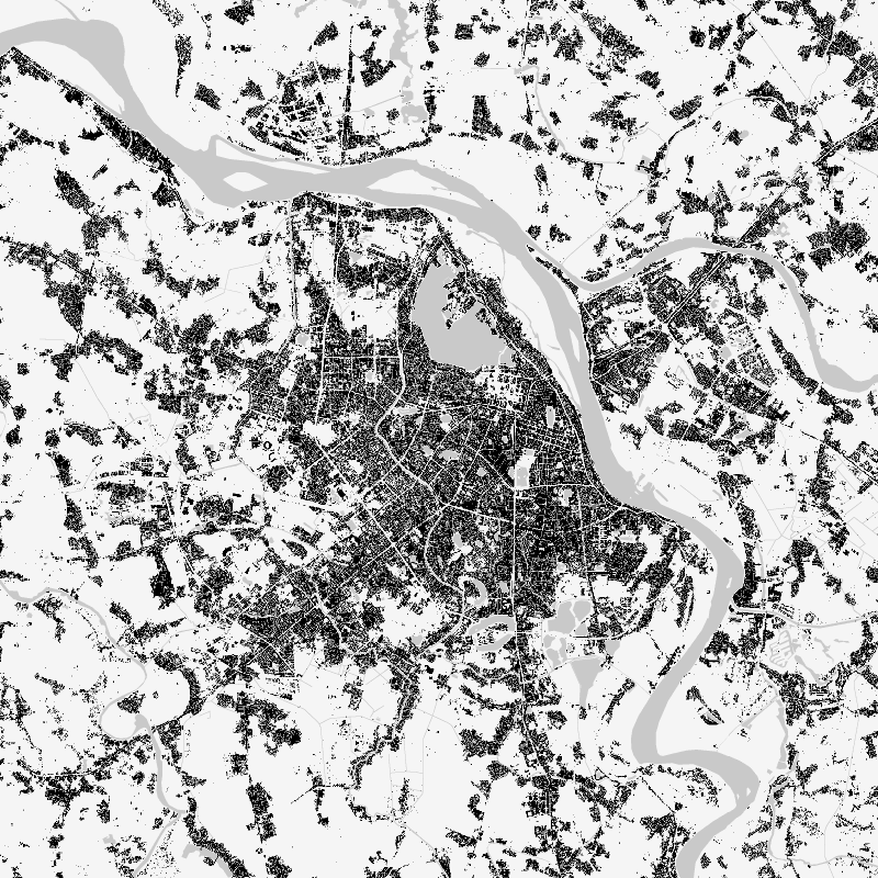
- The WSF2019 has been generated by means of an advanced classification system which jointly exploits open-and-free optical and radar satellite imagery acquired for the year 2019. In particular, ~286K Sentinel-1 and ~2M Sentinel-2 scenes have been processed, respectively.
- Description
-
World Settlement Footprint - WSF2019 Processing:
Processing:
First, suitable temporal features are generated out of radar Sentinel-1 and optical Sentinel-2 data. Next, training points for the settlement and non-settlement class are derived by thresholding a subset of these, which varies depending on the corresponding Köppen Geiger climate type. Binary Random Forest classification is then applied and a dedicated post-processing is finally performed where ancillary datasets are used to further reduce omission and commission errors.
Quality Assurance:
The WSF2019 has been validated against 1M ground-truth samples collected – with the support of Google and Mapswipe - by crowdsourcing photointerpretation of reference very high-resolution satellite imagery. To this purpose a statistically robust and transparent protocol has been defined following recommended state-of-the-art practices.
gmd:MD_Metadata
- File identifier
- cbc6cb05-1245-41f9-a866-051119441187 XML
- Metadata language
- English
- Character set
- UTF8
- Hierarchy level
- Dataset
- Hierarchy level name
- Dataset
- Date stamp
- 2025-02-03T09:13:59
- Metadata standard name
- 19115-1:2014/19139
- Metadata standard version
- 2003/Cor.1:2006
Point of contact
Overviews
Provided by
