 POC 3.12
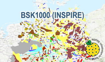
INSPIRE: Map of Mineral Resources of Germany 1:1,000,000 (BSK1000) (WMS)
The WMS BSK1000 (INSPIRE) provides basic information on the spatial distribution of energy resources and mineral raw materials (‘stones and earth’, industrial minerals and ores) in Germany on a scale of 1:1,000,000. The BSK1000 is published by the Federal Institute for Geosciences and Natural Resources in cooperation with the State Geological Surveys of Germany. According to the Data Specification on Mineral Resources (D2.8.III.21) the map provides INSPIRE-compliant data. The WMS BSK1000 (INSPIRE) contains five layers:
MR.Mine displays important mines.
MR.MineralOccurence.Commodity.Point.EnergyResourcesAndMineralRawMaterials displays small-scale energy resources and mineral raw materials as points.
MR.MineralOccurence.Commodity.Polygon.DistributionOfSalt displays the distribution of salt.
MR.MineralOccurrence.Commodity.Polygon.EnergyResources displays large-scale energy resources as polygons.
MR.MineralOccurrence.Commodity.Polygon.MineralRawMaterials displays large-scale mineral raw materials as polygons.
The user obtains detailed information on the mineral raw materials, energy resources and mines via the getFeatureInfo request.
Notes regarding the portrayal:
The colouring of the large- and small-scale energy resources and mineral raw materials as well as of the mines corresponds largely to the colouring of the KOR250 respectively KOR250 (INSPIRE). In addition, the gas and oil polygons are coloured in green and red according to common international practice. The black coal polygons are displayed in their original colour grey. Also the colours of the mine symbols correspond largely to the KOR250 respectively KOR250 (INSPIRE) colouring. Only the salt and potash mine symbols have their original colour. All mine symbols are BGR symbols. The distribution areas of the Triassic and Zechstein salt show the corresponding geochronological INSPIRE colours (see Data Specification on Geology D2.8.II.4_v3.0). The distribution area of salt diapirism is displayed in a BGR colour.
Der WMS BSK1000 (INSPIRE) liefert grundlegende Informationen zur räumlichen Verteilung von Energierohstoffen und mineralischen Rohstoffen (Steine und Erden, Industrieminerale und Erze) in Deutschland im Maßstab 1:1.000.000. Die BSK1000 wird von der Bundesanstalt für Geowissenschaften und Rohstoffe in Zusammenarbeit mit den Staatlichen Geologischen Diensten Deutschlands herausgegeben. Entsprechend der Datenspezifikation Mineral Resources (D2.8.III.21) liegen die Inhalte der Karte INSPIRE-konform vor. Die BSK1000 (INSPIRE) enthält fünf Layer:
MR.Mine stellt wichtige Abbaustellen dar.
MR.MineralOccurence.Commodity.Point.EnergyResourcesAndMineralRawMaterials stellt kleinflächige Energierohstoffe und mineralische Rohstoffe als Punkte dar.
MR.MineralOccurence.Commodity.Polygon.DistributionOfSalt stellt Verbreitungsgebiete von Salzen dar.
MR.MineralOccurrence.Commodity.Polygon.EnergyResources stellt großräumige Energierohstoffe als Flächen dar.
MR.MineralOccurrence.Commodity.Polygon.MineralRawMaterials stellt großräumige mineralische Rohstoffe als Flächen dar.
Mit Hilfe der getFeatureInfo-Anfrage erhält der User Detailinformationen zu den Energierohstoffen, mineralischen Rohstoffen und wichtigen Abbaustellen.
Anmerkungen zur Darstellung:
Die Farbgebung der groß- und kleinräumigen Energierohstoffe und mineralischen Rohstoffe sowie der Abbaustellen entspricht überwiegend der Farbgebung in der KOR250 bzw. KOR250 (INSPIRE). Zusätzlich werden für die farbliche Darstellung der Gas- und Ölflächen die international üblichen Farben Grün und Rot verwendet. Steinkohleflächen werden in der Original-Farbe Grau dargestellt. Die Farben der Abbaustellen-Symbole entsprechen ebenfalls überwiegend der KOR250 bzw. KOR250 (INSPIRE)-Farbgebung. Nur „salt“ und “potash“ werden in der Original-Farbe dargestellt. Die Symbole der Abbaustellen sind BGR-Symbole. Die Verbreitungsgebiete der Trias- und Zechstein-Salze werden mit der entsprechenden geochronologischen INSPIRE-Farbe (siehe Datenspezifikation Geology D2.8.II.4_v3.0) dargestellt. Gebiete mit Salzdiapirismus sind in einer BGR eigenen Farbe dargestellt.
Simple
Identification info
- Alternate title
-
BSK1000 (WMS) (INSPIRE)
- Date (Publication)
- 2020-10-23
- Identifier
- https://registry.gdi-de.org/id/de.bund.bgr.csw/f11869f5-ffaa-f3ef-43ff-1220181d92af
- Status
- Completed
-
GEMET - INSPIRE themes, version 1.0
-
-
Mineralische Bodenschätze
-
Mineral resources
-
-
GEMET - Themes, version 4.1.4
-
-
black coal
-
building material
-
clay
-
coal
-
crude oil
-
energy
-
energy resource
-
energy source
-
energy source material
-
fossil fuel
-
gravel
-
gypsum
-
lignite
-
limestone
-
mine
-
mineral deposit
-
natural gas
-
oil shale
-
ore
-
peat
-
petroleum
-
potash
-
raw material
-
salt
-
sand
-
- Place
-
-
Germany
-
Deutschland
-
-
Spatial scope
-
-
National
-
- Keywords
-
-
infoMapAccessService
-
inspireidentifiziert
-
opendata
-
- Access constraints
- Other restrictions
- Other constraints
- Es gelten keine Zugriffsbeschränkungen
- Use constraints
- Other restrictions
- Other constraints
-
Terms of Use: General terms and conditions, see https://www.bgr.bund.de/AGB_en. For further use provided information has to be cited as follows: BSK1000 (INSPIRE), (c) BGR Hannover, 2020
- Other constraints
-
Dieser Datensatz kann gemäß der "Nutzungsbestimmungen für die Bereitstellung von Geodaten des Bundes" ( https://sg.geodatenzentrum.de/web_public/gdz/lizenz/geonutzv.pdf) genutzt werden.
- Service Type
- view
- Service Version
-
OGC:WMS 1.3.0
))
Coupled Resource
- Operation Name
-
getMap
- Coupling Type
- Tight
Contains Operations
- Operation Name
-
GetCapabilities
- Distributed Computing Platforms
- Web services
- Connect Point
- https://services.bgr.de/wms/inspire_mr/bsk1000/?
Contains Operations
- Operation Name
-
GetMap
- Distributed Computing Platforms
- Web services
- Connect Point
- https://services.bgr.de/wms/inspire_mr/bsk1000/?
- Unique resource identifier
- EPSG:25832
- Distribution format
-
-
png
(
n/a
)
-
jpeg
(
n/a
)
-
gif
(
n/a
)
-
png
(
n/a
)
- OnLine resource
- https://services.bgr.de/wms/inspire_mr/bsk1000/?REQUEST=GetCapabilities&SERVICE=wms&VERSION=1.3.0
- OnLine resource
- Karte im BGR-Geoviewer
- Hierarchy level
- Service
- Other
-
Service
Conformance result
- Date (Publication)
- 2013-04-04
- Explanation
-
See the referenced specification
- Pass
- Yes
Conformance result
- Date (Publication)
- 2009-10-20
- Explanation
-
See the referenced specification
- Statement
-
The WMS BSK1000 (INSPIRE) is based on the spatial dataset of the Map of Mineral Resources of Germany 1:1,000,000 (BSK1000) transformed according to INSPIRE.
- File identifier
- e744e123-c929-4b1f-8716-4af466f8a294 XML
- Metadata language
- English
- Character set
- UTF8
- Hierarchy level
- Service
- Hierarchy level name
-
Rohstoffe
- Hierarchy level name
-
INSPIRE
- Date stamp
- 2020-10-23
- Metadata standard name
-
ISO19115/ISO19119
- Metadata standard version
-
n/a
Overviews
Spatial extent
Provided by
