 POC 3.12
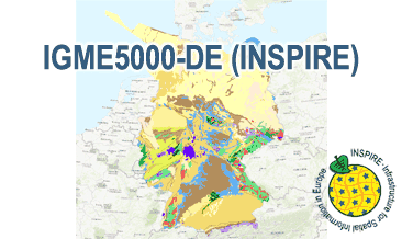
INSPIRE: The 1:5 Million International Geological Map of Europe and Adjacent Areas - German part (IGME5000-DE) (WMS)
The IGME5000-DE (INSPIRE) represents the pre-quaternary bedrock geology (section of Germany) of the European map on a scale of 1:5,000,000. According to the Data Specification on Geology (D2.8.II.4_v3.0) the geological map provides INSPIRE-compliant data. The WMS IGME5000-DE contains layers of the geologic units (GE.GeologicUnit) and faults (GE.GeologicFault) mostly displayed according to the INSPIRE portrayal rules. The geologic units are represented graphically by stratigraphy (GE.GeologicUnit.AgeOfRocks) and lithology (GE.GeologicUnit.Lithology). For different geochronologic minimum and maximum ages, e.g. Ordovician - Silurian, the portrayal is defined by the color of the geochronologic minimum age (olderNamedAge). The portrayal of the lithology is defined by the first named rock or rock group. In case of the geologic units the user obtains detailed information via the getFeatureInfo request on the lithology and stratigraphy (age).
Die IGME5000-DE (INSPIRE) zeigt die präquartäre Festgesteinsgeologie (deutscher Ausschnitt) des europäischen Kartenwerkes im Maßstab 1:5.000.000. Entsprechend der Datenspezifikation Geology (D2.8.II.4_v3.0) liegen die Inhalte der Karte INSPIRE-konform vor. Der WMS IGME5000-DE (INSPIRE) beinhaltet Layer mit den geologischen Einheiten (GE.GeologicUnit) und Verwerfungen (GE.GeologicFault), die überwiegend gemäß der INSPIRE-Darstellungsregeln abgebildet sind. Die geologischen Einheiten sind anhand der Stratigraphie (GE.GeologicUnit.AgeOfRocks) und der Petrographie (GE.GeologicUnit.Lithology) dargestellt. Bei unterschiedlichen geochronologischen Anfangs- und Endalter-Angaben, z.B. Ordovizium - Silur, entspricht die farbliche Darstellung dem geochronologischen Anfangsalter (olderNamedAge). Bei der petrographischen Darstellung ist die Farbe des erstgenannten Gesteins oder der erstgenannten Gesteinsgruppe ausschlaggebend. Mit Hilfe der getFeatureInfo-Anfrage erhält der User im Fall der geologischen Einheiten Detailinformationen zur Petrographie (lithology) und Stratigraphie (age).
INSPIRE
Identification
- File identifier
- ed091713-21b6-4f11-88a4-c78777d9d24a XML
- Hierarchy level
- Service
Online resource
Resource identifier
Encoding
- Format
-
png
- Version
-
n/a
- Format
-
jpeg
- Version
-
n/a
- Format
-
gif
- Version
-
n/a
Projection
- code
- EPSG:25832
Classification of data and services
- Service Type
- view
- Coupling Type
- Tight
Coupled resource
Coupled resource
Classification of data and services
- Service Type
- view
- Coupling Type
- Tight
Coupled resource
Coupled resource
Keywords
-
GEMET - INSPIRE themes, version 1.0
-
-
Geologie
-
Geology
-
-
Spatial scope
-
-
National
-
Other keywords
- Theme
-
-
inspireidentifiziert
-
infoMapAccessService
-
opendata
-
- Place
-
-
Deutschland
-
Germany
-
Geographic coverage
))
Temporal reference
Temporal extent
Temporal extent
- Date (Publication)
- 2019-05-10
Quality and validity
- Lineage
-
The WMS IGME5000-DE (INSPIRE) is based on the spatial dataset of The 1:5 Million International Geological Map of Europe and Adjacent Areas – German part (IGME5000-DE) transformed according to INSPIRE.
Conformity
Conformity
Conformity
Conformity
Conformity
Conformity
- Explanation
-
See the referenced specification
Restrictions on access and use
- Access constraints
- Es gelten keine Zugriffsbeschränkungen
- Access constraints
-
Allgemeine Geschäftsbedingungen, siehe https://www.bgr.bund.de/AGB - General terms and conditions, see https://www.bgr.bund.de/AGB_en. Die bereitgestellten Informationen sind bei Weiterverwendung wie folgt zu zitieren: Datenquelle: IGME5000-DE (INSPIRE), (c) BGR, Hannover, 2019.
- Access constraints
-
Dieser Datensatz kann gemäß der "Nutzungsbestimmungen für die Bereitstellung von Geodaten des Bundes" ( https://sg.geodatenzentrum.de/web_public/gdz/lizenz/geonutzv.pdf) genutzt werden.
Responsible organization (s)
Contact for the resource
- Organisation name
-
Bundesanstalt für Geowissenschaften und Rohstoffe (BGR)
-
geologie.daten@bgr.de geologie.daten@bgr.de
Responsible organization (s)
Contact for the resource
- Organisation name
-
Bundesanstalt für Geowissenschaften und Rohstoffe (BGR)
-
geologie.daten@bgr.de geologie.daten@bgr.de
Metadata information
Contact for the metadata
- Organisation name
-
Bundesanstalt für Geowissenschaften und Rohstoffe (BGR)
-
geodatenmanagement@bgr.de geodatenmanagement@bgr.de
- Date stamp
- 2021-09-14
- Metadata language
- English
SDS
Conformance class 1: invocable
Access Point URL
Endpoint URL
Technical specification
- Date
- Explanation
-
See the referenced specification
Conformance class 2: interoperable
Access constraints
- Access constraints
- Other restrictions
- Other constraints
- Es gelten keine Zugriffsbeschränkungen
Limitation
Use constraints
Limitation
- string
-
Allgemeine Geschäftsbedingungen, siehe https://www.bgr.bund.de/AGB - General terms and conditions, see https://www.bgr.bund.de/AGB_en. Die bereitgestellten Informationen sind bei Weiterverwendung wie folgt zu zitieren: Datenquelle: IGME5000-DE (INSPIRE), (c) BGR, Hannover, 2019.
- string
-
Dieser Datensatz kann gemäß der "Nutzungsbestimmungen für die Bereitstellung von Geodaten des Bundes" ( https://sg.geodatenzentrum.de/web_public/gdz/lizenz/geonutzv.pdf) genutzt werden.
Responsible custodian
Contact for the resource
Conformance class 3: harmonized
Contains Operations
- Operation Name
-
GetCapabilities
- Distributed Computing Platforms
- Web services
- Connect Point
- https://services.bgr.de/wms/inspire_ge/igme5000de/?
Contains Operations
- Operation Name
-
GetMap
- Distributed Computing Platforms
- Web services
- Connect Point
- https://services.bgr.de/wms/inspire_ge/igme5000de/?
Overviews
Spatial extent
Provided by
