 POC 3.12
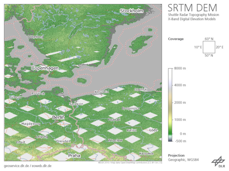
SRTM X-SAR - Digital Elevation Model (DEM) 10° Mosaics - Global
The Shuttle Radar Topography Mission (SRTM, DTS-99) from February 11 to 22, 2000 was an US-German-Italian effort to produce a first global digital elevation model (DEM). The German Aerospace Center (DLR) and the Italian Space Agency (ASI) complemented the US C-band Synthetic Aperture Radar (SAR) payload of NASA/JPL with an additional X-SAR instrument. The SRTM X-SAR DEM was generated at DLR from this instrument’s data using radar interferometry technique.
The data was acquired simultaneously from aboard the Space Shuttle Endeavor employing two SAR antennas, one inside the Space Shuttle’s cargo bay, the other at the end of a 60 m extension pole. A substantial portion of the global land surface between 60° northern and 58° southern latitude was covered.
As the orbit flown and imaging period of the SRTM mission had been optimized for the US C-band system, the German-Italian X-SAR with narrower aperture angle imaged data only along roughly 50 km wide orbital ground traces. Therefore, the dataset available shows a grid-like coverage.
The original SRTM X-SAR DTED DEMs have been merged to 10° by 10° tiles, converted to GeoTIFF format and packaged into zip-archives. Each zip-file contains the DEM dataset, the corresponding height error map (HEM), a quicklook png-image, a kml-overlay and a readme document. The filename of the zip-archive specifies the bottom left coordinate of each tile. The zip-archives can be downloaded via the EOC Download Service.
For more information see: https://geoservice.dlr.de/resources/licenses/srtm_xsar/DLR_SRTM_XSAR_ReadMe.pdf
INSPIRE
Identification
- File identifier
- f4d4079a-ada3-41d0-ba95-630ba232e147 XML
- Hierarchy level
- Dataset
Online resource
- Protocol
-
WWW:LINK-1.0-http--link
- Protocol
-
WWW:LINK-1.0-http--link
Resource identifier
- Metadata language
- Deutsch
- Spatial representation type
- Grid
Encoding
- Format
-
GeoTIFF
Projection
- code
- EPSG:4326
Classification of data and services
- Topic category
-
- Elevation
Classification of data and services
Coupled resource
Coupled resource
Classification of data and services
Coupled resource
Coupled resource
Keywords
-
GEMET - INSPIRE themes, version 1.0
-
-
Höhe
-
Other keywords
- Theme
-
-
DLR
-
Elevation
-
Space Shuttle
-
STS-99
-
SRTM
-
X-SAR
-
Digital Elevation Model (DEM)
-
regional mosaics
-
Global
-
inspireidentifiziert
-
Geographic coverage
))
Temporal reference
Temporal extent
- Begin
- 2000-01-11T00:00:00
- End
- 2000-01-22T00:00:00
Temporal extent
- Date (Creation)
- 2000-01-11T00:00:00
Quality and validity
- Lineage
-
Horizontal accuracy (absolute): ±20m 90% circular error
Horizontal accuracy (relative): ±15m 90% circular error
Vertical accuracy (absolute): ±16m 90% circular error
Vertical accuracy (relative): ±6m 90% circular error
- Denominator
- 50000
Conformity
Conformity
Conformity
Conformity
Conformity
Conformity
- Explanation
-
See the referenced specification.
Restrictions on access and use
- Access constraints
- Es gelten keine Zugriffsbeschränkungen
- Access constraints
-
Nutzungsbedingungen: https://geoservice.dlr.de/resources/licenses/srtm_xsar/DLR_SRTM_XSAR_ReadMe.pdf / Terms of use: https://geoservice.dlr.de/resources/licenses/srtm_xsar/DLR_SRTM_XSAR_ReadMe.pdf
Responsible organization (s)
Contact for the resource
- Organisation name
-
German Aerospace Center (DLR)
-
geoservice@dlr.de geoservice@dlr.de
Responsible organization (s)
Contact for the resource
- Organisation name
-
German Aerospace Center (DLR)
-
geoservice@dlr.de geoservice@dlr.de
Metadata information
Contact for the metadata
- Organisation name
-
German Aerospace Center (DLR)
-
geoservice@dlr.de geoservice@dlr.de
- Date stamp
- 2023-01-25T09:45:28
- Metadata language
- Deutsch
- Character set
- UTF8
SDS
Conformance class 1: invocable
Access Point URL
Endpoint URL
Technical specification
Conformance class 2: interoperable
Access constraints
Limitation
Use constraints
Limitation
Responsible custodian
Contact for the resource
Overviews
Spatial extent
Provided by
