 INSPIRE-1
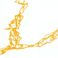
Gebiete naturbedingter Risiken Hessen - Hochwasser_mit_hoher_Wahrscheinlichkeit
Überflutungsflächen bei Hochwasser in Hessen: Bezeichung nach Wasserhaushaltsgesetz (WHG) §74 und nach WHG §76 (bzw. §45 Hessisches Wassergesetz (HWG)).:Überflutungsflächen eines Hochwassers mit hoher Wahrscheinlichkeit in Hessen (Bezeichnung nach Wasserhaushaltsgesetz (WHG) §74): Überflutungsflächen mit einem voraussichtlichen Wiederkehrintervall von mindestens 10 Jahren (entspricht einem 10-jährlichen Hochwasser, HQ10). Einzelne Gebiete haben auch eine abweichende Jährlichkeit für das Hochwasser mit hoher Wahrscheinlichkeit. Teil des Datenbestands der Hochwasserrisikomanagementpläne (HWRMP) in Hessen.
|
|
Citation proposal
. Gebiete naturbedingter Risiken Hessen - Hochwasser_mit_hoher_Wahrscheinlichkeit. Hessisches Landesamt für Naturschutz, Umwelt und Geologie http://gdk-inspire-1.ffm.gdi-de.org/geonetwork/srv/api/records/fd072e64-a4a8-df4e-7513-66ac1efbe178 |
INSPIRE
Identification
- File identifier
- fd072e64-a4a8-df4e-7513-66ac1efbe178 XML
- Hierarchy level
- service Service
Online resource
- Protocol
- OGC:WMS-1.1.1-http-get-map
Resource identifier
Encoding
Projection
Classification of data and services
Classification of data and services
- Service Type
- view
- Coupling Type
- Tight
Coupled resource
Coupled resource
Classification of data and services
- Service Type
- view
- Coupling Type
- Tight
Coupled resource
Coupled resource
Keywords
- mapbender.2.registryId
-
- 1c349fea-924b-488f-b6a2-e896f40ac897
Other keywords
- Keywords
-
- regional
- HQ10
- HWRMP
- Hochwasserrisikomanagementpläne
- Wasser
- Hydrologie
- Überschwemmungsgebiete
- Überflutungsflächen
- naturbedingte Risiken
- Gebiete mit naturbedingten Risiken
- Hochwasser
- Hessen
- HLNUG
- Hydrology
- Natural risk zones
- infoMapAccessService
- inspireidentifiziert
- inspireidentifiziert
Geographic coverage
N
S
E
W
))
Temporal reference
Temporal extent
Temporal extent
- Date ( Revision )
- 2024-01-19
Quality and validity
Conformity
Conformity
Conformity
Conformity
Conformity
Conformity
- Explanation
- No explanation available
- Explanation
- No explanation available
- Explanation
- No explanation available
- Explanation
- No explanation available
- Explanation
- No explanation available
- Explanation
- No explanation available
- Explanation
- No explanation available
- Explanation
- No explanation available
Restrictions on access and use
Restrictions on access and use
- Access constraints
- Dienst und Daten stellen keine rechtsverbindliche Auskunft dar. Die kostenfreie Nutzung der Geo- und Metadaten sowie der Geodatendienste ist für private und kommerzielle Zwecke erlaubt. Lizenz: Creative Commons BY 4.0. Quellenvermerk für Dienst: „Hessisches Landesamt für Naturschutz, Umwelt und Geologie“. Quellenvermerk für Daten: „Darstellung auf der Grundlage von Daten des Hessischen Landesamtes für Naturschutz, Umwelt und Geologie“.
Responsible organization (s)
Contact for the resource
- Organisation name
- Hessisches Landesamt für Naturschutz, Umwelt und Geologie
Responsible organization (s)
Contact for the resource
- Organisation name
- Hessisches Landesamt für Naturschutz, Umwelt und Geologie
Metadata information
Contact for the metadata
- Organisation name
- HLNUG
- arcgis@hlnug.hessen.de
- Date stamp
- 2024-11-19
- Metadata language
- Deutsch German
SDS
Conformance class 1: invocable
- Pass
- true
- Pass
- true
- Pass
- true
- Pass
- true
- Pass
- true
- Pass
- true
- Pass
- true
- Pass
- true
Access Point URL
Endpoint URL
Technical specification
- Date
- Explanation
- No explanation available
- Date
- Explanation
- No explanation available
- Date
- Explanation
- No explanation available
- Date
- Explanation
- No explanation available
- Date
- Explanation
- No explanation available
- Date
- Explanation
- No explanation available
- Date
- Explanation
- No explanation available
- Date
- Explanation
- No explanation available
Conformance class 2: interoperable
Coordinate reference system
Quality of Service
Access constraints
- Access constraints
- Other restrictions
Limitation
Use constraints
Limitation
- string
- Dienst und Daten stellen keine rechtsverbindliche Auskunft dar. Die kostenfreie Nutzung der Geo- und Metadaten sowie der Geodatendienste ist für private und kommerzielle Zwecke erlaubt. Lizenz: Creative Commons BY 4.0. Quellenvermerk für Dienst: „Hessisches Landesamt für Naturschutz, Umwelt und Geologie“. Quellenvermerk für Daten: „Darstellung auf der Grundlage von Daten des Hessischen Landesamtes für Naturschutz, Umwelt und Geologie“.
Responsible custodian
Contact for the resource
Conformance class 3: harmonized
Contains Operations
- Operation Name
- GetCapabilities
- Distributed Computing Platforms
- Web services
Overviews
Thumbnail
Provided by

Views
fd072e64-a4a8-df4e-7513-66ac1efbe178
Access to the portal
Read here the full details and access to the data.
Associated resources
Not available