 POC 3.12

Type of resources
Available actions
Topics
Keywords
Contact for the resource
Provided by
Years
Formats
Representation types
Update frequencies
Service types
Scale
-

2m temperature measurements at DWD stations in the Regional Basic Synoptic Network of the WMO, plus additional stations from the so called "Global Dataset" of DWD
-
Web Map Service of Deutscher Wetterdienst for climate data
-
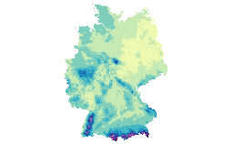
Grids are derived from DWD stations and legally and qualitatively equivalent partner stations in Germany.
-
-
calculated values for potential Evaporation over gras at DWD stations in the Regional Basic Synoptic Network of the WMO, plus additional stations from the so called "Global Dataset" of DWD
-
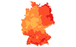
Grids are derived from DWD stations and legally and equivalent partner stations in Germany.
-
-
Karten zu mittlerer, minimaler und maximaler Temperatur (2m), Niederschlag, Sonnenscheindauer für Deutschland; jeweils Jahres- und Monatsreferenz als langjähriger Mittelwert (1961-1990) abgeleitet aus Messungen der Stationen des Deutschen Wetterdienstes. Der GeoServer des DWD stellt Jahresreferenzkarten bereit. Diese sind unter folgenden Bezeichnungen zu finden: TAMM_17_1961_30 (Durchschnittstemperatur), TADNMM_17_1961_30 (mittlere Minimaltemperatur), TADXMM_17_1961_30 (mittlere Maximaltemperatur), SDMS_17_1961_30 (Sonnenscheindauer), RSMS_17_1961_30 (Niederschlag). Monatbezogene Rasterdaten und weitere Parameter stehen zum Download auf dem CDC-FTP-Server bereit. Generelle Informationen zum Datenangebot des CDC, sowie Erläuterungen zu den Nutzungsrechten sind zu finden unter: ftp://ftp-cdc.dwd.de/pub/CDC .
-
precipitation measurements at DWD stations in the Regional Basic Synoptic Network of the WMO, plus additional stations from the so called "Global Dataset" of DWD
-
relative humidity measurements at DWD stations in the Regional Basic Synoptic Network of the WMO, plus additional stations from the so called "Global Dataset" of DWD