 INSPIRE-1
Keyword
land use
13 record(s)
Provided by
Type of resources
Available actions
Topics
Keywords
Contact for the resource
Update frequencies
Service types
-
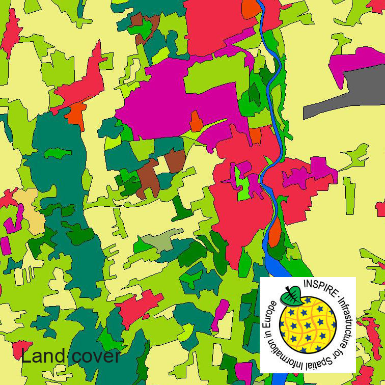
This dataset clc5 (2012) describes the landscape according to the CORINE Land Cover (CLC) nomenclature. These classes contain mainly information about landcover mixed with some aspects of landuse. CLC5 is based on the more detailed German landcover model from 2012 (LBM-DE2012) which uses separate classes for landcover and landuse and attribute-information about percentage of vegetation and sealing. The mimimum unit for an object is 1 ha. For the CLC5 dataset landcover and landuse classes are combined to unique CLC-classes taking into account the percentage of vegetation and sealing , followed by a generalisation process.
-
This dataset clc5 (2015) describes the landscape according to the CORINE Land Cover (CLC) nomenclature. These classes contain mainly information about landcover mixed with some aspects of landuse. CLC5 is based on the more detailed German landcover model from 2015 (LBM-DE2015) which uses separate classes for landcover and landuse and attribute-information about percentage of vegetation and sealing. The mimimum unit for an object is 1 ha. For the CLC5 dataset landcover and landuse classes are combined to unique CLC-classes taking into account the percentage of vegetation and sealing , followed by a generalisation process.
-
This dataset clc5 (2018) describes the landscape according to the CORINE Land Cover (CLC) nomenclature. These classes contain mainly information about landcover mixed with some aspects of landuse. CLC5 is based on the more detailed German landcover model from 2018 (LBM-DE2018) which uses separate classes for landcover and landuse and attribute-information about percentage of vegetation and sealing. The mimimum unit for an object is 1 ha. For the CLC5 dataset landcover and landuse classes are combined to unique CLC-classes taking into account the percentage of vegetation and sealing , followed by a generalisation process.
-
Der Datensatz „INSPIRE BW Bodennutzung Flächeninformation und Online-Antrag FIONA“ stellt die Bodennutzung von landwirtschaftlich genutzten Flächen dar. Die Polygone zeigen die Grenzen einer, im Rahmen des Gemeinsamen Antrages 2022, gemeldeten Nutzung. Die Daten werden im Rahmen der Gemeinsamen Agrarpolitik der EU erhoben und sind Bestandteil des Verwaltungssystems von Baden-Württemberg. Ein Polygon liegt nur dann vor, wenn die landwirtschaftliche Fläche im Gemeinsamen Antrag beantragt worden ist. Die Polygone wurden anonymisiert.
-

Bauleitpläne im Kreis Stormarn inkl. der Plan-PDFs
-
Der Datensatz „INSPIRE BW Bodennutzung Flächeninformation und Online-Antrag FIONA ab 2023“ stellt die Bodennutzung von landwirtschaftlich genutzten Flächen dar. Die Polygone zeigen die Grenzen einer, im Rahmen des Gemeinsamen Antrages, gemeldeten Nutzung. Die Daten werden im Rahmen der Gemeinsamen Agrarpolitik der EU erhoben und sind Bestandteil des Verwaltungssystems von Baden-Württemberg. Ein Polygon liegt nur dann vor, wenn die landwirtschaftliche Fläche im Gemeinsamen Antrag beantragt worden ist. Die Polygone wurden anonymisiert.
-

Der interoperable INSPIRE-WFS ist ein Downloaddienst, der Daten im Annex-Schema Existierende Bodennutzung (abgeleitet aus dem originären Datensatz: Daten aus dem Agrarförderantrag) bereitstellt. Gemäß der INSPIRE-Datenspezifikation Land Use (D2.8.III.4_v3.0.0) liegen die Inhalte INSPIRE-konform vor. Der WFS beinhaltet die folgenden FeatureTypes: • Datensatz zur existierenden Bodennutzung (elu:ExistingLandUseDataSet): Ein Datensatz zur existierenden Bodennutzung ist eine Sammlung von Flächen, für die Informationen zur existierenden (gegenwärtigen oder früheren) Bodennutzung angegeben sind. • Objekt zur existierenden Bodennutzung (elu:ExistingLandUseObject): Ein Objekt zur existierenden Bodennutzung beschreibt die Bodennutzung in einem Gebiet mit einheitlicher Bodennutzungskategorie oder homogener Kombination verschiedener Bodennutzungen. --- The compliant INSPIRE-WFS is a download service that delivers data in the Annex-Schema Existing Land Use (derived from the original data set: Data from the agricultural aid application). The content is compliant to the INSPIRE data specification for the annex theme Land Use (D2.8.III.4_v3.0.0). The WFS includes the following feature types: • Existing land use data set (elu:ExistingLandUseDataSet): An existing land use data set is a collection of areas for which information on existing (present or past) land uses is provided. • Existing land use object (elu:ExistingLandUseObject): An existing land use object describes the land use of an area having a homogeneous combination of land use types. Maßstab: 1:2400; Bodenauflösung: 2.4m; Scanauflösung (DPI): null
-
Der interoperable INSPIRE-Datensatz beinhaltet Daten der EU-Zahlstelle BB über die landwirtschaftlichen Parzellen in Brandenburg, transformiert in das INSPIRE-Zielschema Bodennutzung. Der Datensatz wird über je einen interoperablen Darstellungs- und Downloaddienst bereitgestellt. --- The compliant INSPIRE data set contains data about the agricultural parcels in the State of Brandenburg from the paying agency, transformed into the INSPIRE annex schema Land Use. The data set is provided via compliant view and download services.
-
Der Datenbestand enthält aus ALKIS abgeleitete Daten für das INSPIRE-Thema Existierende Bodennutzung gemäß INSPIRE-Datenspezifikation.
-
Der interoperable INSPIRE-WMS ist ein Darstellungsdienst, der Daten im Annex-Schema Existierende Bodennutzung (abgeleitet aus dem originären Datensatz: Daten aus dem Agrarförderantrag) bereitstellt. Gemäß der INSPIRE-Datenspezifikation Land Use (D2.8.III.4_v3.1.1) liegen die Inhalte INSPIRE-konform vor. Der WMS beinhaltet den folgenden Layer: • LU.ExistingLandUse: Ein Objekt zur existierenden Bodennutzung beschreibt die Bodennutzung in einem Gebiet miteinheitlicher Bodennutzungskategorie oder homogener Kombination verschiedener Bodennutzungen. --- The compliant INSPIRE-WFS is a view service that delivers data in the Annex-Schema Existing Land Use (derived from the original data set: Data from the agricultural aid application). The content is compliant to the INSPIRE data specification for the annex theme Land Use (D2.8.III.4_v3.1.1). The WMS includes the following layer: • LU.ExistingLandUse: An existing land use object describes the land use of an area having a homogeneous combination of land use types. Maßstab: 1:2400; Bodenauflösung: 2.4m; Scanauflösung (DPI): null