 INSPIRE-1
Type
service-view
114089 record(s)
Provided by
Type of resources
Available actions
Keywords
Contact for the resource
Update frequencies
Service types
-
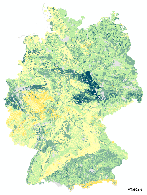
The map of the available water holding capacity in Germany gives an overview of the amount of water in a soil that is normally available for plant growth. The map shows the available water from the surface to effective rooting depth, which is derived from land use and soli data. The method is published in the Bodenkundliche Kartieranleitung KA4 (1994) and in the documentation of Ad-hoc-AG Boden (representing the soil experts of the geological services of the German federal states). The land use information is taken from the CORINE Land Cover data set (2006).
-
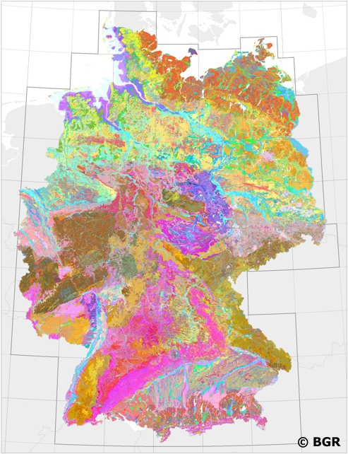
Web Map Service (WMS) of BUEK200 series. The soil map 1:200,000 (BUEK200) is prepared by the Federal Institute for Geosciences and Natural Resources (BGR) in cooperation with the National Geological Surveys (SGD) of the federal states in the sheet line system of the Topographic Map 1:200,000 (TUEK200) and is published in 55 individual map sheets. The digital data management provides a detailed, nationwide uniform and comprehensive information base for statements on land use and soil protection across the states. The soil inventories and their spatial distribution on the territory of each map sheet is currently described in terms of legend units structured by soil regions and landscapes. Each legend unit contains soil systematic information as well as information about the soil parent material of each dominant and associated soil.
-

INSPIRE theme Elevation (depth contours). It contains the depth contour of hydrographic surveying.
-
-
The Web Map Service (WMS) shows the distribution of typical soil types (soil texture) in the topsoils of Germany. Typical is used in the term of areally dominating. The map visualizes the results of the project that are documented in a BGR report (Bodenarten der Böden Deutschlands; BGR Archiv, Nr. 0127305). The soil texture data from the analysis of the particle size distribution for 16,132 sites in Germany were classified after the legend units of land use-stratified soil map of Germany 1: 1,000,000 (BÜK1000N V2.3) and mean soil texture were calculated. Considering the large heterogeneity in the data and the resulting uncertaintly in the precision for a site the depiction of the obtained soil texture is presented at the level of the soil types group, according to the German soil classification system (KA5).
-
Which salt formations are suitable for storing hydrogen or compressed air? In the InSpEE-DS research project, scientists developed requirements and criteria for the assessment of suitable sites even if their exploration is still at an early stage and there is little knowledge of the salinaries’ structures. Scientists at DEEP.KBB GmbH in Hanover, worked together with their project partners at the Federal Institute for Geosciences and Natural Resources and the Leibniz University Hanover, Institute for Geotechnics Hanover, to develop the planning basis for the site selection and for the construction of storage caverns in flat layered salt and multiple or double saliniferous formations. Such caverns could store renewable energy in the form of hydrogen or compressed air. While the previous project InSpEE was limited to salt formations of great thickness in Northern Germany, salt horizons of different ages have now been examined all over Germany. To estimate the potential, depth contour maps of the top and the base as well as thickness maps of the respective stratigraphic units and reference profiles were developed. The information on compressed air and hydrogen storage potential in the federal states is linked to the identified areas with usable potential in the Layer Storage potential in the federal states (Speicherpotenzial in den Bundesländern). Via the getFeatureInfo request, the user obtains additional information on the different geometries. This enables access to the criteria catalog data sheet in the layer Potential storage areas for flat layered salt (Potenzielle Speichergebiete flach lagernde Salze) of each stratigraphic unit and to the illustrations of borehole profiles and borehole correlations in the layers Boreholes (Bohrungen) and Borehole correlations (Bohrungskorrelationen). Spatial selection and data queries are possible for the following data sets: Boreholes (Bohrungen), Borehole correlations (Bohrungskorrelationen), Isobath (Isobathen), Isopach (Isopachen), Boundary elements of the potential areas Top Zechstein (Begrenzungselemente der Potenzialgebiete Top Zechstein), Storage potential in the federal states (Speicherpotenzial in den Bundesändern) and potential storage areas in the flat layered Zechstein salt (Potenzielle Speichergebiete flach lagernde Zechsteinsalze). The scale of display is limited to a minimum of 1:300.000. This geographic information is product of a BMWi-funded research project "InSpEE-DS" running from the year 2015 to 2019. The acronym stands for "Information system salt: planning basis, selection criteria and estimation of the potential for the construction of salt caverns for the storage of renewable energies (hydrogen and compressed air) - double saline and flat salt layers".
-
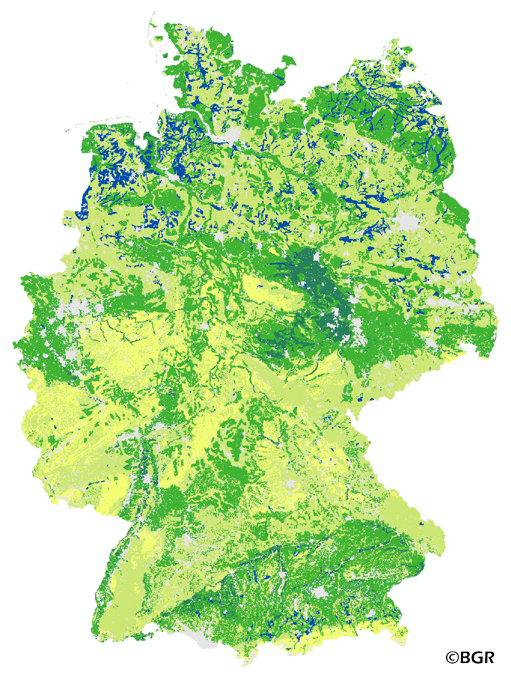
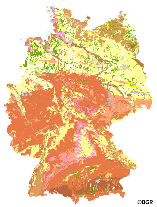
The map of the field capacity of soils in Germany gives an overview of the amount of water which can be stored in a soil (depth 1 m). The water storage capacity is a key function of soils. The field capacity was derived from the landuse stratified soil map of Germany at scale 1:1,000,000. The method is published in the Bodenkundliche Kartieranleitung KA4 (1994) and in the documentation of Ad-hoc-AG Boden (representing the soil experts of the geological services of the German federal states). The land use information is derived from the CORINE Land Cover data set (2006).
-

-
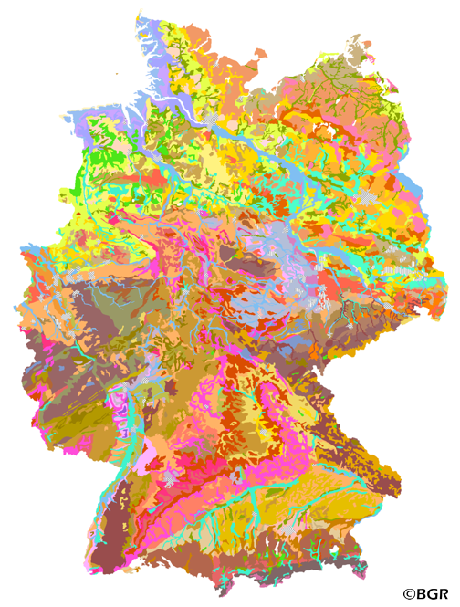
Web Map Service (WMS) of the BUEK2000. The BUEK2000 Version 1.0 was compiled from the BÜK1000 map by a process of generalization. The number of soil mapping units in the legend was reduced from 72 to 60 by aggregation of those units showing similar dominamt soils into single units. The map combined with selected soil profile pictures/graphics and information about soil history, soil classification and soil mapping in Germany is one fundamental part of the Hydrological Atlas of Germany (HAD). The Version 2.0, based on the BUEK2000N, Version 2.3, was cartographically adapted to a new base map.
-
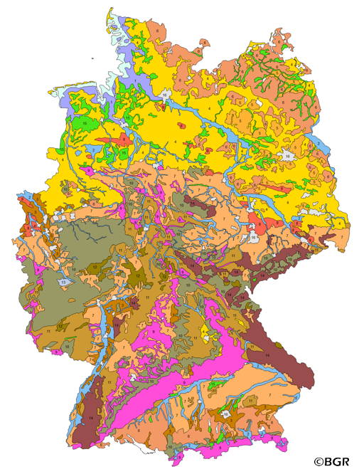
Web Map Service (WMS) of the map Groups of soil parent material in Germany 1:5,000,000. The presented map at scale 1:5,000,000 shows the distribution of 15 soil parent material groups in Germany with polygons of at least 64 square kilometers. Parent material is the rock, from which soil is formed. It was derived from the landuse use stratified soil map of Germany at scale 1:1,000,000. The version 3.0 of the map is based on the Digital Landscape Model 1:1,000,000 (DLM1000) of the Federal Agency for Cartography and Geodesy.