 INSPIRE-1
Topic
elevation
105 record(s)
Provided by
Type of resources
Available actions
Topics
Keywords
Contact for the resource
Update frequencies
-

INSPIRE theme Elevation (depth contours). It contains the depth contour of hydrographic surveying.
-

INSPIRE theme Elevation (bathymetry). Provision of the topography of the seabed in the North and Baltic Sea.
-
-
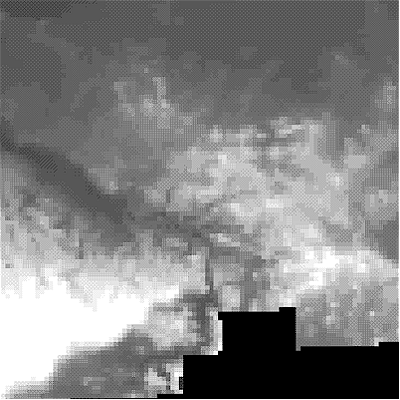
The TanDEM-X DEM Change Maps is a project developed by the Institute Remote Sensing Technology (IMF) at the German Aerospace Center (DLR) within the activities of the TanDEM-X Mission. Between 2016 and 2022, the TanDEM-X mission acquired an additional complete coverage of the Earth's landmass to deliver a temporally independent coverage within a well-defined time span. These new acquisitions not only provide more up-to-date elevation information, but also a great dataset to show the changes that have occurred during the years separating this new coverage from the coverages acquired to generate the TanDEM-X global DEM (between 2011 and 2014). This product - the TanDEM-X 30 m DEM Change Maps - shows the changes between the edited first global TanDEM-X DEM (TanDEM-X 30m Edited DEM) and the newly acquired time-tagged DEM scenes. In order to keep a unique timestamp, two change maps are available per tile: one with the change to the oldest pixel in the new dataset - the first DEM change, and another with the change to the newest pixel of the new dataset - the last DEM change. The two maps differ only when there are multiple coverages. Users must be aware that a given elevation change measured in the DEM change maps corresponds to a topographic change with respect to TanDEM-X 30m EDEM, but cannot be associated with a corresponding physical height change of the same magnitude. This is due to the fact that the global TanDEM-X DEM reflects an averaged elevation derived from the combination of different images, acquired over a period of several years but also because the radar waves penetrate differently in the surface depending on the attributes of the land cover. This is especially important over vegetated and snow-covered regions.
-
Das bildbasierte digitale Oberflächenmodell (bDOM) beschreibt höhenmäßig die Erdoberfläche mit allen natürlichen (z.B. Vegetation) und künstlichen Objekten (z.B. Bauwerke). Das bDOM liegt in Form eines gleichmäßigen Rasters mit einer Rasterweite von einem Meter im Blattschnitt 2 km x 2km vor. Die Bereitstellung der Höhendaten erfolgt durch Bilddaten im TIFF-Format. In dazugehörigen GML-Dateien sind sie durch Attribute des INSPIRE-Datenmodells "Höhenlage" beschrieben.
-

Der interoperable INSPIRE-Datensatz beinhaltet Daten vom LBGR über den Scheitelbereichsindex in Brandenburg, zugeordnet in das INSPIRE-Zielschema Höhenlage. Der Datensatz wird über je einen interoperablen Darstellungs- und Downloaddienst bereitgestellt. --- The compliant INSPIRE data set contains data about the culmination zone index in the State of Brandenburg from the LBGR, assigned to the INSPIRE target schema Elevation. The data set is provided via a compliant view and download service.
-
Der interoperable INSPIRE-Datensatz beinhaltet Daten vom LBGR über die Höhe über Tiefenlinien (dicht) in Brandenburg, zugeordnet in das INSPIRE-Zielschema Höhenlage. Der Datensatz wird über je einen interoperablen Darstellungs- und Downloaddienst bereitgestellt. --- The compliant INSPIRE data set contains data about the height above isobath (dense) in the State of Brandenburg from the LBGR, assigned to the INSPIRE target schema Elevation. The data set is provided via a compliant view and download service.
-
Der interoperable INSPIRE-Datensatz beinhaltet Daten vom LBGR über den Divergenz-Konvergenz Index Brandenburg, zugeordnet in das INSPIRE-Zielschema Höhenlagen. Der Datensatz wird über je einen interoperablen Darstellungs- und Downloaddienst bereitgestellt. --- The compliant INSPIRE data set contains data about the divergence-convergence index in the State of Brandenburg from the LBGR, assigned to the INSPIRE target schema Elevation. The data set is provided via a compliant view and download service.
-

Der interoperable INSPIRE-Datensatz beinhaltet Daten vom LBGR zur Exposition Brandenburg, zugeordnet in das INSPIRE-Zielschema Höhenlage. Der Datensatz wird über je einen interoperablen Darstellungs- und Downloaddienst bereitgestellt. --- The compliant INSPIRE data set contains data from the LBGR on the exposition in the State of Brandenburg, assigned to the INSPIRE target schema Elevation. The data set is provided via a compliant view and download service.
-
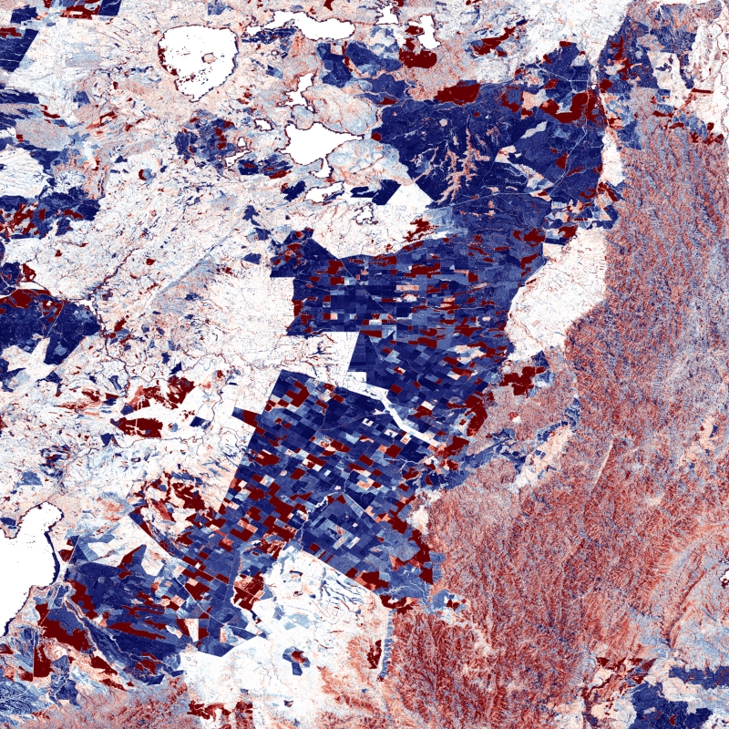
Digitale Geländemodelle (DGM) beschreiben das Relief der Erdoberfläche durch ein regelmäßiges oder unregelmäßiges Punktraster, wobei für jeden Rasterpunkt die Lage und die Höhe bekannt sind. Es wird zwischen verschiedenen DGM je nach Höhengenauigkeit und Rasterweite unterschieden.