 INSPIRE-1
Keyword
infoMapAccessService
114465 record(s)
Provided by
Type of resources
Available actions
Keywords
Contact for the resource
Update frequencies
Service types
-
View service (WMS)
-

INSPIRE View Service for geographical names of municipalities or parts thereof, landscapes, mountain ranges, mountains, islands, rivers, canals, lakes, seas, etc. Data is provided for the Federal Republic of Germany. The dataset is structured according to the INSPIRE Annex I Theme - Geographical Names. The selection of the geographical names is based on the map scale 1 : 250 000 and is derived from different statistical sources, Digital Landscape Models 1 : 250 000 (DLM250) and Digital Elevation Model grid width 10 m (DGM10). This service is published under the Ordinance to Determine the Conditions for Use for the Provision of Spatial Data of the Federation (GeoNutzV) and thereof free of charge.
-
This WMS provides access to different elevation products provided by the Earth Observation Center (EOC) of the DLR.
-
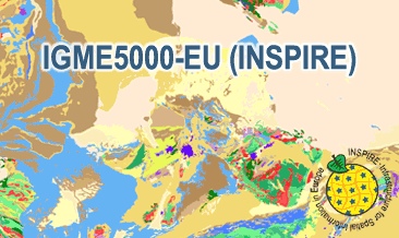
The IGME5000-EU (INSPIRE) represents the pre-quaternary bedrock geology (onshore and offshore) of the European map on a scale of 1:5,000,000. According to the Data Specification on Geology (D2.8.II.4_v3.0) the geological map provides INSPIRE-compliant data. The WMS IGME5000-EU contains layers of the geologic units (GE.GeologicUnit) and faults (GE.GeologicFault) mostly displayed according to the INSPIRE portrayal rules. The geologic units are represented graphically by stratigraphy (GE.GeologicUnit.AgeOfRocks) and lithology (GE.GeologicUnit.Lithology). For different geochronologic minimum and maximum ages, e.g. Ordovician - Silurian, the portrayal is defined by the color of the geochronologic minimum age (olderNamedAge). The portrayal of the lithology is defined by the first named rock or rock group. In case of the geologic units the user obtains detailed information via the getFeatureInfo request on the lithology and stratigraphy (age).
-
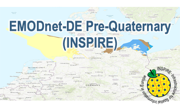
Compilation of the European Pre-Quaternary marine geology (section of Germany). Project partners are the national geological services of the participating countries. The map consists of data at highest available spatial resolution, map scale („multi-resolution“-concept) and data completeness vary depending on the project partner (as of 2016 September). According to the Data Specification on Geology (D2.8.II.4_v3.0) the geological map provides INSPIRE-compliant data. The WMS EMODnet-DE Pre-Quaternary (INSPIRE) contains layers of the geologic units (GE.GeologicUnit) displayed correspondingly to the INSPIRE portrayal rules. The geologic units are represented graphically by stratigraphy (GE.GeologicUnit.AgeOfRocks) and lithology (GE.GeologicUnit.Lithology). The portrayal of the lithology is defined by the first named rock or rock group. Via the getFeatureInfo request the user obtains detailed information on the lithology, stratigraphy (age) and genesis (event environment and event process).
-
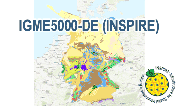
The IGME5000-DE (INSPIRE) represents the pre-quaternary bedrock geology (section of Germany) of the European map on a scale of 1:5,000,000. According to the Data Specification on Geology (D2.8.II.4_v3.0) the geological map provides INSPIRE-compliant data. The WMS IGME5000-DE contains layers of the geologic units (GE.GeologicUnit) and faults (GE.GeologicFault) mostly displayed according to the INSPIRE portrayal rules. The geologic units are represented graphically by stratigraphy (GE.GeologicUnit.AgeOfRocks) and lithology (GE.GeologicUnit.Lithology). For different geochronologic minimum and maximum ages, e.g. Ordovician - Silurian, the portrayal is defined by the color of the geochronologic minimum age (olderNamedAge). The portrayal of the lithology is defined by the first named rock or rock group. In case of the geologic units the user obtains detailed information via the getFeatureInfo request on the lithology and stratigraphy (age).
-
INSPIRE View Service for Digital Terrain Model Grid Width 200 m (DGM200). The Digital Terrain Model DGM200 describes the terrain forms of the earth’s surface by means of a point quantity arranged in a regular grid, which is georeferenced to planimetry and altimetry. The grid width is 200 m. The data provided through this service covers the area of Germany. Ground resolution: 200m
-
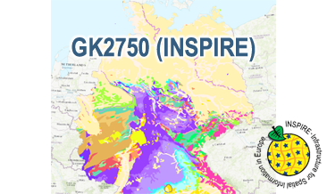
The WMS GK2750 Geology (INSPIRE) represents the surface geology of Germany on a scale of 1:2,750,000. According to the Data Specification on Geology (D2.8.II.4_v3.0) the geological map provides INSPIRE-compliant data. The WMS GK2750 Geology (INSPIRE) contains layers of the geologic units (GE.GeologicUnit), faults (GE.GeologicFault) and marginal position of the ice shield and the impact crater Nördlinger Ries (GE. GeomorphologicFeature) displayed correspondingly to the INSPIRE portrayal rules. The geologic units are represented graphically by stratigraphy (GE.GeologicUnit.AgeOfRocks) and lithology (GE.GeologicUnit.Lithology). For different geochronologic minimum and maximum ages, e.g. Upper Devonian - Permian, the portrayal is defined by the colour of the geochronologic minimum age (olderNamedAge). In case of the geologic units the user obtains detailed information via the getFeatureInfo request on the lithology, stratigraphy (age) and genesis (event environment and event process).
-
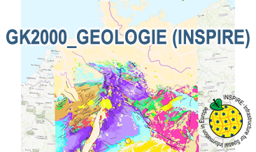
The WMS GK2000 Geologie (INSPIRE) represents the surface geology of Germany and adjacent areas on a scale of 1:2,000,000. According to the Data Specification on Geology (D2.8.II.4_v3.0) the geological map provides INSPIRE-compliant data. The WMS GK2000 Geologie (INSPIRE) contains layers of the geologic units (GE.GeologicUnit), faults (GE.GeologicFault) and marginal position of the ice shield as well as the impact craters Nördlinger Ries and Steinheimer Becken (GE. GeomorphologicFeature) displayed correspondingly to the INSPIRE portrayal rules. The geologic units are represented graphically by stratigraphy (GE.GeologicUnit.AgeOfRocks) and lithology (GE.GeologicUnit.Lithology). For different geochronologic minimum and maximum ages, Upper Devonian - Permian, the portrayal is defined by the colour of the geochronologic minimum age (olderNamedAge). In case of the geologic units the user obtains detailed information via the getFeatureInfo request on the lithology, stratigraphy (age) and genesis (event environment and event process).
-
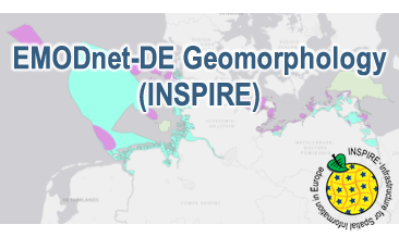
Compilation of the European marine geomorphology (section of Germany). According to the Data Specification on Geology (D2.8.II.4_v3.0) the geological map provides INSPIRE-compliant data. The WMS EMODnet-DE Geomorphology (INSPIRE) contains layers of the natural geomorphologic features (GE.GeomorphologicFeature) displayed correspondingly to the INSPIRE portrayal rules. Via the getFeatureInfo request the user obtains detailed information on the natural geomorphologic features.