 INSPIRE-1
Topic
geoscientificInformation
742 record(s)
Provided by
Type of resources
Available actions
Topics
Keywords
Contact for the resource
Update frequencies
-
Compilation of the European Pre-Quaternary marine geology (section of Germany). Project partners are the national geological services of the participating countries. The map consists of data at highest available spatial resolution, map scale („multi-resolution“-concept) and data completeness vary depending on the project partner (as of 2016 September). According to the Data Specification on Geology (D2.8.II.4_v3.0) the content of the geological map is stored in a INSPIRE-compliant GML file: EMODnet-DE_Pre-Quaternary_GeologicUnit.gml contains the geologic units. The GML files together with a Readme.txt file are provided in ZIP format (EMODnet-DE_Pre-Quaternary-INSPIRE.zip). The Readme.text file (German/English) contains detailed information on the GML file content. Data transformation was proceeded by using the INSPIRE Solution Pack for FME according to the INSPIRE requirements.
-
The map Organic Matter Content of Top-Soils in Germany 1:1,000,000 highlights the results of a Germany-wide compilation of typical soil organic matter contents in top-soils differentiated according to 15 groups of soil parent material, four climatic areas and the main land use. The evaluation is based on more than 9000 soil data profiles with information about Soil Organic Matter (SOM) from a period of about 20 years. The report 'The Organic Matter Content of Top-Soils in Germany', BGR Archiv, No. 0127036 (in German) documents the methodology. The classes of the map legend are based on the classes given in the German Soil Mapping Guideline, 5th Edition (KA5).
-
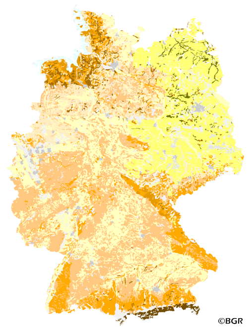
The BUEK5000 is derived form the landuse stratified soil map of Germany at scale 1:1,000,000 by aggregation, focused on information about the parent material, and generalization. The maps shows 20 soil (23) legend units with polygons of at least 64 square kilometers.
-
Compilation of the European Quaternary marine geology (section of Germany). The map consists of data at highest available spatial resolution, map scale („multi-resolution“-concept) and data completeness vary depending on the project partner (as of 2019 April). Project partners are the national geological services of the participating countries. According to the Data Specification on Geology (D2.8.II.4_v3.0) the content of the geological map is stored in a INSPIRE-compliant GML file: EMODnet-DE_Quaternary_GeologicUnit.gml contains the geologic units. The GML file together with a Readme.txt file are provided in ZIP format (EMODnet-DE_Quaternary-INSPIRE.zip). The Readme.text file (German/English) contains detailed information on the GML file content. Data transformation was proceeded by using the INSPIRE Solution Pack for FME according to the INSPIRE requirements.
-
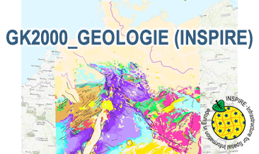
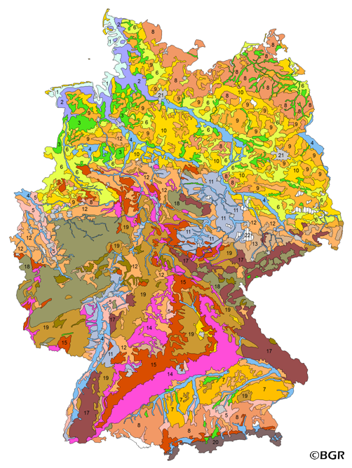
The GK2000 Geologie (INSPIRE) represents the surface geology of Germany on a scale of 1:2,000,000. According to the Data Specification on Geology (D2.8.II.4_v3.0) the content of the geological map is stored in three INSPIRE-compliant GML files: GK2000_Geology_GeologicUnit.gml contains the geologic units, GK2000_Geology_GeologicStructure.gml comprises the faults and GK2000_Geology_GeomorphologicFeature.gml represents the marginal position of the ice shield as well as the impact craters Nördlinger Ries and Steinheimer Becken. The GML files together with a Readme.txt file are provided in ZIP format (GK2000_Geologie-INSPIRE.zip). The Readme.text file (German/English) contains detailed information on the GML files content. Data transformation was proceeded by using the INSPIRE Solution Pack for FME according to the INSPIRE requirements.
-
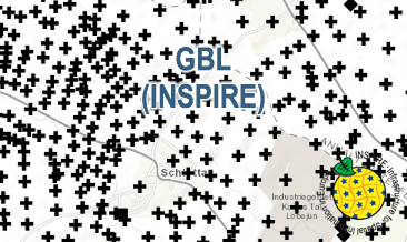
The GBL (INSPIRE) represents mechanically drilled boreholes approved by the State Geological Surveys of Germany (SGS). Most of the drilling data were not collected by the SGS, but were transmitted to SGS by third parties in accordance with legal requirements. Therefore, the SGS can accept no responsibility for the accuracy of the information. According to the Data Specification on Geology (D2.8.II.4_v3.0) the boreholes of each federal state are stored in one INSPIRE-compliant GML file. The GML file together with a Readme.txt file is provided in ZIP format (e.g. GBL-INSPIRE_Lower_Saxony.zip). The Readme.txt file (German/English) contains detailed information on the GML file content. Data transformation was proceeded by using the INSPIRE Solution Pack for FME according to the INSPIRE requirements.
-
-
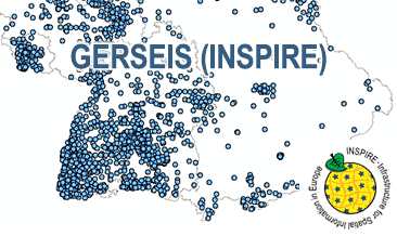
The German Earthquake Catalogue is based on a database providing information on the seismicity in Germany an adjacent areas. It contains locations of seismic events since year 800 where their epicentre determinations are based on historical sources as well as on measurements at seismometer stations since the start of instrumental seismological recording in the 20th century. Today, digital data acquisition at seismometer stations of the German regional seismic network (GRSN), the seismic GERES array, and the Gräfenberg array (GRF) takes place. All events with a local magnitude ML 2.0 and higher are listed. The GML file together with a Readme.txt file are provided in ZIP format (GERSEIS-INSPIRE.zip). The Readme.text file (German/English) contains detailed information on the GML file content. Data transformation was proceeded by using the INSPIRE Solution Pack for FME according to the INSPIRE requirements. Due to the continuous processing of the seismic events, the INSPIRE dataset is updated annually.
-
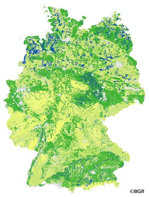
The map of the field capacity of soils in Germany gives an overview of the amount of water which can be stored in a soil (depth 1 m). The water storage capacity is a key function of soils. The field capacity was derived from the landuse stratified soil map of Germany at scale 1:1,000,000. The method is published in the Bodenkundliche Kartieranleitung KA4 (1994) and in the documentation of Ad-hoc-AG Boden (representing the soil experts of the geological services of the German federal states). The land use information is derived from the CORINE Land Cover data set (2006).
-
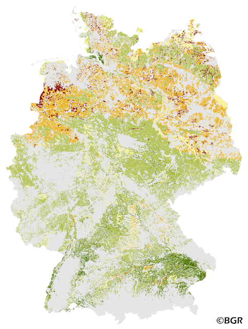
The Potential Wind Erosion Risk map gives an overview of the exposure of arable soils to soil loss due to deflation in Germany. It is based on pedological and climatic factors. The method to predict the soil erosion risk is published in the DIN 19706:2002 and in the documentation of Ad-hoc-AG Boden (representing the soil experts of the geological services of the German federal states). For the application with soil maps, the method was adapted by the Federal Institute for Geosciences and Natural Resources (BGR).The land use stratified soil map of Germany at scale 1:1,000,000 was used as pedological input to the model. The mean annual wind speed at 10 meters above ground level of the period 1980-2000 (DWD) is used as well. The land use information is derived from CORINE land cover data set (2006).