 INSPIRE-1
Keyword
Rohstoff
69 record(s)
Provided by
Type of resources
Available actions
Topics
Keywords
Contact for the resource
Update frequencies
Service types
-
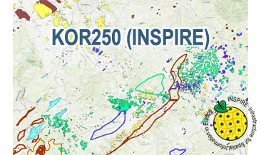
The WMS KOR250 (INSPIRE) in the scale of 1:250,000 shows occurrences and deposits of mineral resources in Germany, which lie close to the Earth’s surface, i.e. can be mined in open-pits, quarries or near-surface mines. These mineral resources include industrial minerals, aggregates, peat, lignite, oil shales, and natural brines. The map is derived from the KOR250, the digital successor of the map series KOR200 „Map of Near-Surface Deposits of the Federal Republic of Germany 1:200,000”, which has been published since 1984. The KOR200 and KOR250 have been published by the Federal Institute for Geosciences and Natural Resources together with the State Geological Surveys of the federal states on behalf of the Federal Ministry for Economic Affairs and Energy. Primary purpose of the KOR250 is to display Germany’s potential of domestic raw materials in a comparable way. The explanations given in the printed booklets accompanying the KOR200 are not available in the digital KOR250. In the KOR250 besides the defined deposits and differently coloured areas of raw materials, "active mines" (= operations) at time of publication or "focal points of several active mines" are marked with one symbol each. These mines are not included in the KOR250 (INSPIRE) as often the headquarters of the mining company and not the mining site itself is displayed as well as in many regions the dataset is outdated. As the map sheets of the KOR200 have been generated over more than three decades the timeliness of data is extremely different. For more detail, the current large-scale raw material maps of the Federal State Geological Surveys should always be consulted. The point data displayed in KOR250 (INSPIRE) indicate very small, but worth mentioning prospects of certain raw materials. The WMS KOR250 (INSPIRE) contains the two layers MR.MineralOccurence.Commodity.Polygon (mineral resources as polygons) and MR.MineralOccurence.Commodity.Point (mineral resources as points). Via the getFeatureInfo request the user obtains additional information on the mineral resources. Notes: The colouring of the raw material occurrences in the KOR250 (INSPIRE) largely corresponds to the colouring of the original KOR250. In the INSPIRE Data Specification on Mineral Resources (D2.8.III.21) there are no portrayal rules for building raw materials and dimension stones, which constitute a large part of the raw material occurrences. It should be noted that according to the INSPIRE commodity code list, most magmatites and metamorphites were assigned to the two values "granite" and "basalt". From a geological point of view and with regard to its origin, this assignment is often misleading. For more information on the outcropping rock of a specific raw material occurrence, the German name from the original KOR250 was mapped to the attribute name of the class GeologicFeature. Link KOR200: https://www.bgr.bund.de/EN/Themen/Min_rohstoffe/Projekte/Rohstoffverfuegbarkeit_laufend_en/KOR_200_en.html
-
.png)
The WMS MSSP-EEZ (INSPIRE) represents marine seismic survey profiles for the German EEZ. During the period from 1996 to 2007 five cruises operated by BGR acquired seismic lines from the German EEZ. The aim of these cruises was a detailed survey of the geological structure of the seabed from the North Sea and Baltic Sea. According to the Data Specification on Geology (D2.8.II.4_v3.0, subtopic Geophysics) the content of the information with respect to the seismic profiles is INSPIRE-compliant. The WMS MSSP-EEZ (INSPIRE) contains for each cruise one layer, e.g. GE.seismicLine.pq2. The expeditions are displayed correspondingly to the INSPIRE portrayal rules. Via the getFeatureInfo request the user obtains the content of the INSPIRE attributes platformType und profileType. Additionally, the WMS contains a campaign layer (GE.2DSeismicSurvey) with the INSPIRE attributes campaignType and surveyType.
-
During the period from 1996 to 2007 five cruises operated by BGR acquired seismic lines from the German EEZ. The aim of these expeditions was a detailed survey of the geological structure of the seabed from the North Sea and Baltic Sea. The five GML files (for each cruise one) together with a Readme.txt file are provided in ZIP format (MSSP-EEZ-INSPIRE.zip). The Readme.text file (German/English) contains detailed information on the GML files content. Data transformation was proceeded by using the INSPIRE Solution Pack for FME according to the INSPIRE requirements.
-
The KOR250 (INSPIRE) in the scale of 1:250,000 shows occurrences and deposits of mineral resources in Germany, which lie close to the Earth’s surface, i.e. can be mined in open-pits, quarries or near-surface mines. These mineral resources include industrial minerals, aggregates, peat, lignite, oil shales, and natural brines. The map is derived from the KOR250, the digital successor of the map series KOR200 „Map of Near-Surface Deposits of the Federal Republic of Germany 1:200,000”, which has been published since 1984. The KOR200 and KOR250 have been published by the Federal Institute for Geosciences and Natural Resources together with the State Geological Surveys of the federal states on behalf of the Federal Ministry for Economic Affairs and Energy. Primary purpose of the KOR250 is to display Germany’s potential of domestic raw materials in a comparable way. The explanations given in the printed booklets accompanying the KOR200 are not available in the digital KOR250. In the KOR250 besides the defined deposits and differently coloured areas of raw materials, "active mines" (= operations) at time of publication or "focal points of several active mines" are marked with one symbol each. These mines are not included in the KOR250 (INSPIRE) as often the headquarters of the mining company and not the mining site itself is displayed as well as in many regions the dataset is outdated. As the map sheets of the KOR200 have been generated over more than three decades the timeliness of data is extremely different. For more detail, the current large-scale raw material maps of the Federal State Geological Surveys should always be consulted. The point data displayed in KOR250 (INSPIRE) indicate very small, but worth mentioning prospects of certain raw materials. According to the Data Specification on Mineral Resources (D2.8.III.21) the content of the map is stored in two INSPIRE-compliant GML files: KOR250_EarthResource_polygon.gml comprises the mineral resources as polygons. KOR250_EarthResource_point.gml comprises the mineral resources as points. The GML files together with a Readme.txt file are provided in ZIP format (KOR250-INSPIRE.zip). The Readme.text file (German/English) contains detailed information on the GML files content. Data transformation was proceeded by using the INSPIRE Solution Pack for FME according to the INSPIRE requirements. Notes: It should be noted that according to the INSPIRE commodity code list, most magmatites and metamorphites were assigned to the two values "granite" and "basalt". From a geological point of view and with regard to its origin, this assignment is often misleading. For more information on the outcropping rock of a specific raw material occurrence, the German name from the original KOR250 was mapped to the attribute name of the class GeologicFeature. Link KOR200: https://www.bgr.bund.de/EN/Themen/Min_rohstoffe/Projekte/Rohstoffverfuegbarkeit_laufend_en/KOR_200_en.html
-
Dieser Datensatz enthält die Altkleidercontainer, Grünabfallcontainer und Altglascontainer der Stadt Osnabrück.
-
Dieser INSPIRE-Dienst beinhaltet die für das INSPIRE-Thema Energy Resources aufbereiteten Daten des Kartenthemas oberflächennahe Geothermie aus dem Informationssystem Geothermie von Nordrhein-Westfalen im Maßstab 1:50.000. Dargestellt wird die oberflächennahe Wärmeleitfähigkeit der Gesteine für Erdwärmesonden mit 40, 60, 80 und 100 Meter Sondenlänge sowie die geothermische Ergiebigkeit für Erdwärmekollektoren.
-
Dieser INSPIRE-Downloaddienst beinhaltet die für das INSPIRE-Thema Energy Resources aufbereiteten Daten des Kartenthemas oberflächennahe Geothermie aus dem Informationssystem Geothermie von Nordrhein-Westfalen im Maßstab 1:50.000. Als Kartenlayer verfügbar sind die oberflächennahe Wärmeleitfähigkeit der Gesteine für Erdwärmesonden mit 40, 60, 80 und 100 Meter Sondenlänge sowie die geothermische Ergiebigkeit für Erdwärmekollektoren.
-
The Map of Mineral Resources of Germany 1: 1,000,000 (BSK1000) provides the basic information on the spatial distribution of energy resources and mineral raw materials (‘stones and earth’, industrial minerals and ores) in Germany. The mineral resources are summarized in commodity groups, represented as different colored units. The map is published by the Federal Institute for Geosciences and Natural Resources in cooperation with the National Geological Surveys.
-

Der interoperable INSPIRE-Datensatz beinhaltet Daten von der GL über den rechtswirksamen Braunkohlenplan Jänschwalde im Land Brandenburg (Rechtsverordnung v. 05.12.2002), transformiert in das INSPIRE-Zielschema Geplante Bodennutzung. Er gibt einen Überblick über den Ansiedlungsstandort, den Abbaubereich, die Sicherheitszone und die Flächennutzungen der Bergbaufolgelandschaft. Der Datensatz wird über je einen interoperablen Darstellungs- und Downloaddienst bereitgestellt. --- The compliant INSPIRE data set contains data about the lignite mining plan Jänschwalde in the State of Brandenburg (Jänschwalde open-cast mine, statutory ordinance of 05.12.2002) from the GL, transformed into the INSPIRE target schema Planned Land Use. The Plan provides an overview of settlement sites, mining areas, safety zones and land uses of the post-mining landscape. The data set is provided via compliant view and download services.
-
Dieser Dienst stellt für das INSPIRE-Thema Mineralische Bodenschätze aus dem Geofachdaten umgesetzte Daten bereit.:Das in der EarthResource enthaltene wirtschaftlich bedeutsame Material.